
-
 11327 Hits
-
 75.81% Score
-
 6 Votes
|
|
Mountain/Rock |
|---|---|
|
|
25.56670°N / 100.4167°W |
|
|
7217 ft / 2200 m |
|
|
Overview
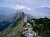
Copete is the highest point of the Chipinque range just south of the city of Monterrey, and also the highest point around the city wich lies at 530m. above sea level. It has incredible views from it`s summit, to the north you can see the whole city and the northern plains, as well as the other mountains that surround the city: Cerro de la Silla and Cerro las Mitras among others; to the south lie the Sierra Madre Oriental, wich this mountain is a part of, with innumerable canyons and rocky peaks, including La Viga, one of the highest mountains in northern México.
The peak lies inside the Chipinque Ecological Park and the trail to it is one of the longest in the park, about seven miles from the park`s entrance; the lower half of it runs across the pine and oak forest wich in parts has been damaged by wildfires,and it`s an easy hike; the middle part is a one hour long zig-zag on steeper ground; the upper part is the most difficult one since it`s rocky and very steep and it`s basically a long
and streneus scramble with some category 5 free climbs on 70-80 degree walls.
 |  |  |  |  |
Getting There
Drivig from downtown Monterrey trough Colonia del Valle to the base of the mountain take the well marked road to Parque Ecológico Chipinque
and drive up about two miles to the park`s entrance, the longer trail starts here, or you can drive up three more miles to the Chipinque plateau where a shorther trail starts and meets the longer one on the road heading to Puerto del Aire, but the steeper trail starts at the last water fountain before reaching this point. The only route to the summit starts here.
Red Tape
You must get a permit at the park`s entrance when not climbing with a mountaineering club. No fees are required unless you take your car into the park (some parking is available outside the park); you must obey the park`s rules specially when it comes to wildlife conservation and wildfire prevention, or risk being fined. Seasonal closures happen specially after heavy rains which can lead to rock and mudslides blocking the road or damaging the trail.
When To Climb
The best time is during the cooler months from October to April, but can be climbed in any month. It`s recommended to start the climb before sunrise with the day`s cooler temperatures specially in the summer since the day`s heat can really heat up the bare rock walls near the summit.
Camping
Camping is NOT allowed anywhere in the park due to wildfire danger.
Mountain Conditions
Parque Ecologico Chipinque phone numbers are:
8303-2190 and 8303-0000, to inquire about conditions.
pacojgarza - Apr 2, 2001 2:22 am - Hasn't voted
Untitled CommentIt normally takes about six to seven hours getting to the summit and back to the park`s entrance.