
|
|
Canyon |
|---|---|
|
|
38.72500°N / 111.056°W |
|
|
Overview
Enigma Canyon is a beautiful and very wild slot canyon located is the San Rafael Swell in east central Utah. The canyon is located between Gem Canyon and Poncho Wash. This canyon is in the least touched and most isolated part of the San Rafael and is in one of the least explored regions of the United States. It is certainly the essence of the wild and unexplored. The first recorded descent of this canyon did not occur until March 2003. Only a handful of people have seen this spectacular and magnificent canyon. This is a rugged technical adventure. The trip is not for beginners. Just finding the trailhead is a serious test of navigation. Climbers and canyoneers should go well prepared before considering this trip.
The canyon is un-named on all the topo maps. We chose the name Enigma Canyon because we couldn't find another name that fits the canyon so well.
The Getting There and Route Description sections are meant to be brief as everyone heading out into this wild area must be self-sufficient.
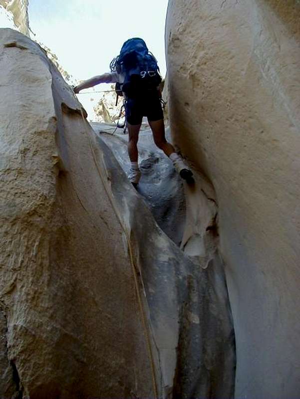
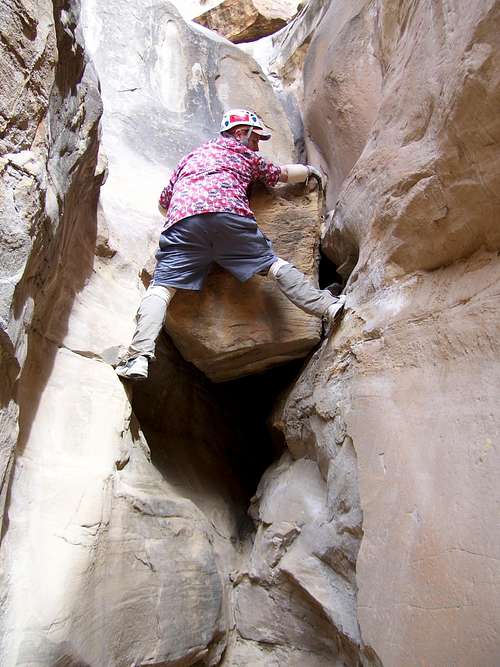 Boulder Obstacle in Enigma Canyon.
Getting There
A journey to out in the middle of no-where............
As mentioned, just finding the trailhead is a navigational challenge. You must do the vehicle shuttle the day before the trip, as it will be a long day just getting through the canyon. You absolutely must have the 7.5 minute quads (maps) Big Bend Draw and Ireland Mesa for the drive to the trailhead. Even then, the maps are inaccurate especially near the trailhead. A 4wd is also required.
To get to the trailhead at the head of the canyon, drive west from Green River, or east of the Emery area along I-70 to exit 108. You must carefully follow the topo maps for the remainder of the drive. Take the southbound gravel road and veer right after a short distance. Stay on the main road until you reach Kimball Draw at an intersection with a sign. This is at about co-ordinates N38*47'16.47" W111*5'52.69". Turn left onto the dirt road signposted for Copper Globe. After following the bottom of the wash for a while, you will reach an intersection (no sign and it can be hard to spot[update: in 2007, there was a sign for "Designated Vehicle Route" here]) at about co-ordinates N38*47'4.42" W111*4'34.19". Turn right onto a seldom used track. Follow the track in and out of several drainages until you reach an intersection at a top of a hill at about co-ordinates N38*46'24.02" W111*3'57.04". Turn right here. The road weaves in and out of drainages and scenic and colorful badlands and is one of the most interesting pieces of road construction I've ever seen. There are some sections of the road that pass through sparkling gypsum beds. Not too far after the road climbs out of Dizzy Trail Canyon (see the topo map), you will reach a junction next to a small hill with a cairn (pile of rocks) on top.
From here on, the topo map is inaccurate as far as showing the many tracks go, so pay attention closely to the topographic features on the map. There are many routes to the trailhead, but here's the route we took. Turn right at the junction with the hill and cairn. You will cross a few very rough spots in the road while crossing two washes. After the second wash, make a very sharp left turn onto a track that heads east [update: this track was just about invisible when we were here in 2007, so see the alternate route below].
Note #1: In 2004, I found an alternate route to the trailhead. The road is not as rough from this alternate route, but the trailhead can be harder to recognize from this direction, as this route has no landmarks near the trailhead. At the hill with the cairn, continue straight instead of right. Look for a faint track to the right not far beyond the hill with the cairn. This road leads to the trailhead, but it’s hard to recognize. Hopefully the cairn I left will still be there!
The trailhead and where you're aiming for is very near the 6350 elevation marked on the Ireland Mesa quad NW of the word "DIKE" on the map. We parked here. There are actually several possible trailheads, including following the track marked on the topo map down to Poncho Wash. We chose to start here because we did Gem Canyon (see the mountain page on that canyon) on the same trip. Otherwise continue past the rough washes as mentioned above and park at the stock tank in Poncho Wash.
Make sure to leave Green River or Castle Dale with a full tank of gas! This area certainly is out in the middle of no-where!
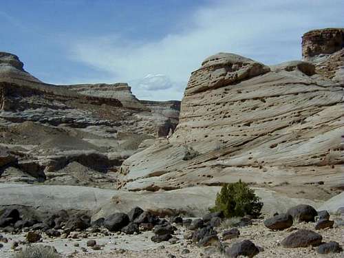
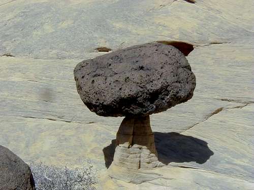 Humorous balanced rock in canyon.
Route Description
This is a loop hike that descends Enigma Canyon to Muddy Creek, then follows Muddy Creek up stream to either Poncho Wash or Dizzy Trail Canyon, and exits via one of those canyons. Alternately, you can also re-ascend the canyon once reaching Muddy Creek.
You must be proficient in routefinding and navigation with a topo map to follow this route. There are several possible routes to the head of the canyon, and all routes require careful navigation with the topo map. There are several drainages that converge before the canyon deepens. Any of them are possible routes and all require some scrambling. Here's the route we took. See the Route Page for much more detail and important coordinates and map references. From the trailhead at elevation 6350 on the topo map, use a compass to head south while crossing several drainages to the little drainages to the head of the canyon. The canyon is shallow for quite a while, but eventually it deepens. There will be several obstacles to surmount. The canyon gets better and better as you continue. Another drop will be encountered that requires a rappel. This is followed by a slot section of the canyon. Continue down canyon. There are several 5th class downclimbs and the longest rappel and it is almost 60 feet. Follow the spectacular slot to Muddy Creek. There are now three options.
Option #1
The first option is to ascend back up the canyon the way you came. Of course to do this, you may have to leave ropes behind at every drop, and you may have to have mechanical ascenders. If you are confident with climbing 5.7, you can upclimb all the drops, as we did in April 2007. Since Enigma Canyon is 3.4 miles long, this route is just under seven miles round trip.
Option #2
The second option is to hike up Muddy Creek to Poncho Wash and climb out a rigorous exit chute, followed by a cross country walk back to the trailhead. This route is about eight miles round trip.
Option #3
The third option is to hike up Muddy Creek to Dizzy Trail Canyon and use that canyon to exit Muddy Creek and hike to the trailhead. Hike up Muddy Creek crossing several times (usually ankle to knee deep unless at flood stage). Use the topo map to locate Dizzy Trail Canyon. It will be the second major canyon coming in form the right. The first canyon is Poncho Wash. Go up Dizzy Trail Canyon until it narrows and divides. The canyon on the left is Cat Canyon. Dizzy Trail is the canyon to the right. Hike up Dizzy Trail Canyon. There is a short section of bushwacking and sometimes running water. Continue up canyon while staying in the main drainage. The canyon walls taper down and eventually the canyon becomes a wash. There are a few bypasses, but eventually you will reach the 4wd road that you used to access the trailhead. Follow the track back to your vehicle (about 1.5 miles).
Make sure to read the route page before heading into the canyon.
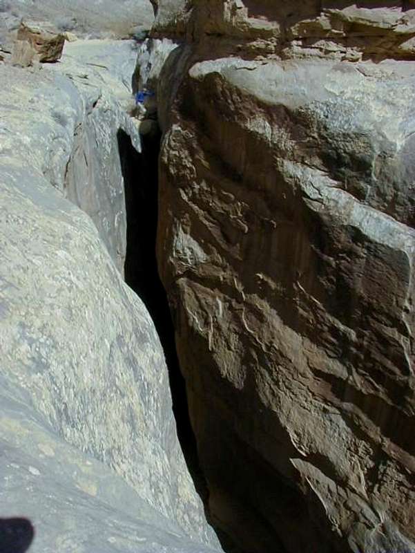
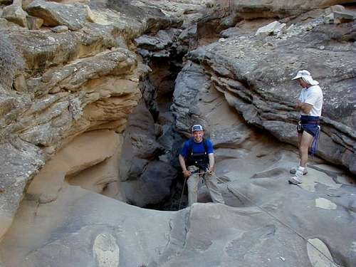 Into the narrows of the canyon.
Clean Canyoneering Ethics
The canyons in this area are very pristine. Bolts are not needed to descend this canyon, and would detract from the incredibly pristine setting of this wild canyon. We saw no signs of previous descent in March of this year. There are plenty of chockstones to wrap slings around for anchors. Try to leave as little behind as possible. This trip is certainly not for beginners; canyoneering techniques must be practiced before going on this trip.
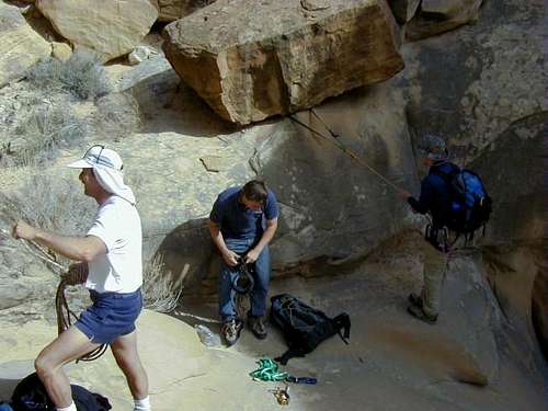 Setting up a natural anchor.
Equipment Needed
Several slings (bring 100 feet minimum), 8-12 rapid links or rappel rings, one 60 meter ropes (200 feet) or two 30m meter (100 foot) ropes, and a climbing harness.
If you wish to re-ascend the canyon instead of doing the loop trip, you will also need 4 or 5 extra 20-30 foot ropes and mechanical ascenders.
 This is the final rappel in the canyon. It goes into a narrow gorge.
Red Tape
No permits are required.
 No red tape here. No private land for miles around.
When To Climb
The trailhead is not accessible between early December through late February in most years. Summer is extremely hot with temperatures exceeding 100F degrees (38C). Winter temperatures drop well below 0F (-18C). The best times of the year for this adventure are mid-March through May and then again in mid-September through mid-November. Muddy Creek can be very cold before April. There is some flash flood potential in the narrow sections, so have a good weather forecast before heading down the canyon. Muddy Creek is usually a very small stream, but in some years it can be waist or more deep in the spring (April and May). This is rare however.
This is a land of weather extremes. Temperatures in the nearest towns have ranged from -42F to 112F at Green River and -35F to 114F at Hanksville. On the day we went through the morning low was 15F and the afternoon high was 77F in the shade. Sunny weather predominates and it only rains a few times a year, but when it does rain, it can really pour! Don't underestimate flash flood danger.
 This is a harsh desert with extremes in temperature.
Camping
There are good campsites at the trailhead(see photo below) as well as many scattered throughout this region. the nearest official campground is many, many miles from this canyon.
You can camp along Muddy Creek if you wish to carry a heavy pack (this will not be easy) through the canyon if doing it as an overnight trip.
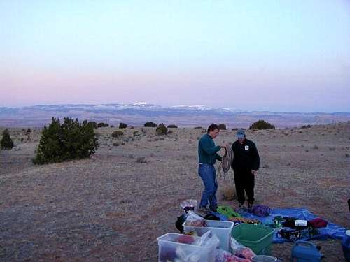 The campsite at the trailhead.
Mountain Conditions
This is the first time this canyon has never been published on a website or guidebook, so there are no links available. Even the topo maps are inaccurate in several sections of this canyon, so you must be self sufficient.
WEATHER FORECAST FOR SAN RAFAEL SWELL
Weather and climate data for the Hanksville is below. *National Weather Service Data 1912-2004.
| MONTH | AVE HIGH | AVE LOW | REC HIGH | REC LOW | AVE PRECIP (in) |
| JAN | 39 | 9 | 69 | -35 | .33 |
| FEB | 49 | 19 | 74 | -33 | .21 |
| MAR | 60 | 27 | 88 | 4 | .42 |
| APR | 70 | 35 | 98 | 10 | .40 |
| MAY | 81 | 44 | 107 | 23 | .46 |
| JUN | 91 | 53 | 110 | 31 | .27 |
| JUL | 97 | 60 | 114 | 38 | .48 |
| AUG | 94 | 57 | 110 | 35 | .80 |
| SEP | 85 | 48 | 105 | 24 | .68<TD |
| OCT | 72 | 35 | 95 | -6 | .68 |
| NOV | 56 | 22 | 82 | -8 | .42 |
| DEC | 44 | 14 | 70 | -24 | .29 |
lscritch2 - Oct 9, 2012 2:14 pm - Hasn't voted
not safely up-climbable soloWhile this is a very nice canyon, Enigma is not a viable escape from Muddy Creek back to the rim. The "stopper" upclimb is only 300' or so from the creek, so you can check it out for yourself. Maybe conditions have changed in recent years. Our party of three experienced climbers did not feel that the upclimb was safe to solo.
Scott - Oct 9, 2012 2:54 pm - Hasn't voted
Re: not safely up-climbable soloFrom recent reports, I don't think it has changed much, but the upclimb is ~5.7, making it fairly challenging. I've upclimbed it with and without a rope, but "safe" is a relative term. There are certainly penalty points for falling. The canyon isn't really presented as being an escape from Muddy Creek to the rim as there are less technical ways to do this (i.e. Poncho Wash). It does say the following: Option #1: The first option is to ascend back up the canyon the way you came. Of course to do this, you may have to leave ropes behind at every drop, and you may have to use mechanical ascenders. If you are confident with climbing 5.7, you can upclimb all the drops, as we did in April 2007. But, that's only presented as an option if you had already descended the canyon.