
|
|
Area/Range |
|---|---|
|
|
46.00722°N / 68.9166°W |
|
|
Hiking, Mountaineering, Trad Climbing, Ice Climbing, Scrambling |
|
|
5268 ft / 1606 m |
|
|
Overview
The Katahdin Group is the most abrupt and compact mountain region in the Appalachians. Its east-west extent is 13 miles and its north-south extent is 18 miles. From the south it looks like a barricade with a gap on the east side between Turner and Katahdin and another on the west narrowly isolating the Doubletop complex from OJI West Peak.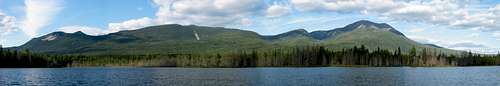
On the southern escarpment both the Doubletop Complex and Turner Mountain are quite distinct from Katahdin and the so-called Katahdinough. The Katahdinough is an L shaped range whose vertex is OJI and whose upper end is Fort Mountain or Mullen Mountain and whose right end is the craggy Owl. Both ends of the "L" are separated from Katahdin by narrow deep defiles. Beneath the east face of the Owl is Witherle Ravine and beneath Fort Mountain is the gorge of Wassataquoik Stream.

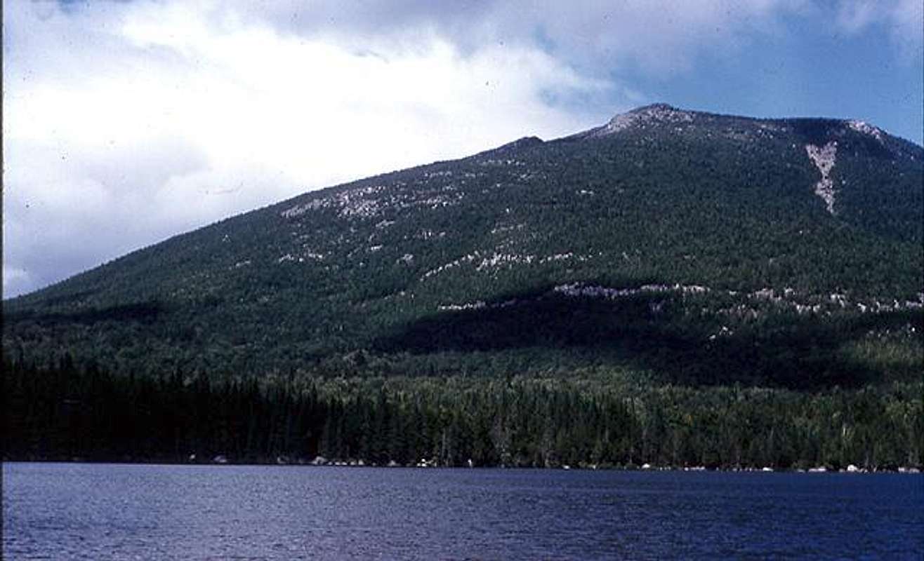
Good views of the southern escarpment are to be had from Millinocket Lake and Ambajejus Lake as well as the Deadwaters of the Penobscot West Branch.
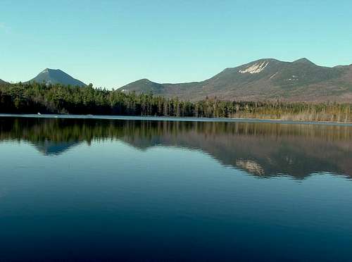
The east side of the group when viewed from Katahin Lake looks like a series of blown out volcanic craters due to the cirques: Great Basin, North Basin and Little North Basin. Pulling farther back to the East Branch of the Penobscot, one sees the detached mass of the Traveler with the Pogys, Mullen and Wassataquoik Mountain in the the middle. Turner is somewhat overshadowed by Katahdin. From the North the mountains appear like a rising series of ridges dominated by Katahdin. From the west it is a rising series of peaks culminating in the Tableland and Baxter Peak.

From the Southwest, Doubletop appears a bit isolated and Katahdin can appear to have a boxy shape anchored by the ridge to the South Peak. The view from Katahdin Lake and the East Branch of the Penobscot River, show Turner rising in front of Katahdin and then the large valley of Wassataquoik Stream with Pogy Mountain and Wassatquoik Mountain enclosing Wassataquoik Lake and to the north of that South Traveler, Traveler and North Traveler descending toward BillFish and Horse Mountains.
From the north one sees two groups of mountains separated by the South Branch valley with its beautiful Mountain ponds From the West the mountains tend to overlap and appear less distinctive.
 |  |  |  |  |
Mountains
The mountains include the Doubletop Complex of Veto, Squaws Bosom and Doubletop. Crossing Nesowdnahunk Stream one finds West Peak(OJI) , OJI, Barren, The Owl, Baxter, South Peak, Chimney Peak, Pamola and TurnerBaxter Peak 5268 ft
South Peak 5240 ft
Chimney Pk 4920 ft
Pamola 4920 ft
Hamlin Peak 4761 ft
North Peaks 4740 ft
North Brother 4151 ft
South Brother 3970 ft
Fort Mountain 3861 ft
Mount Coe 3784 ft
OJI 3434 ft
Barren Mtn. 3690 ft
Traveler Mtn 3551 ft
Doubletop 3488 ft
Mullen Mtn 3460 ft
OJI 3434 ft
North Turner 3326 ft
Cross Range 3292 ft
North Traveler 3152 ft
South Turner 3130 ft
Squaws Bosom 3030 ft
Lesser Summits
Wassataquoik Mtn. 2984 ft
Veto Mtn 2974 ft
Pogy Mtn 2850 ft
Bald Mtn. 2817 ft
Black Cat Mtn 2630 ft
West Peak OJI 2512 ft (shown to the left from Drapper Pd?)
East Turner 2456 ft High Pt of Penobscot County
Lakes and Ponds and Streams
The oft quoted line, which Thoreau does not claim as his own, compares the lakes and ponds of the area to a "mirror broken into a thousand fragments, and wildly scattered over the grass, reflecting the full blaze of the the sun" gives an idea of this multitude. A word on ponds-many of these would be called lakes in other states. The ponds also are viewing points for the mountains- a feature not seen in much of the Appalachians to the south.Lakes: Mattagamon, Webster, Nesowdnehunk, Katahdin are on the edge of Baxter Park and Wassataquoik Lake is in the middle separating Pogy and Wassataquoik Mtns. Ponds south of the escarpment are included Slaughter Pond near Doubletop Kidney Pond,Abol Pond and Togue Ponds. East of Katahdin: Sandy Stream Pond and Whidden Ponds. In the middle Russell Pond, Six Ponds. In the north Upper and Lower South Branch Ponds. On Katahdin Clockwise: Klondike Pond, Davis Pond, Lake Cowles, North Basin ponds, Basin Ponds and Chimney Pond.
To drain these lakes and ponds are: Katahdin Stream, Roaring Brook Sandy stream and Newsownehunk Stream in the south and Wassataquoik Stream in the middle and South Branch Ponds Brook.
Historical and Cultural Stuff
Penobscot Tribe: Believe in a Storm Bird called Pamola(John Gyles writes Gulloua). They opine that the "Teddon" is higher than the White Hills over the Saco (Mt Washington. The Teddon is the site of native tales of mythical beings aiding and repelling would be climbers.. The teen, John Gyles, whose father was tomahawked in York Maine in 1689 provides the first Yankee view of the mountain through the above stories while he was touring the region as a captive of the Malecite Indians for 10 years in Maine. Note this reference is more than 50 years after the first ascent of Agiockochook(Mt. Wash) in 1642. Col. John Montressor may have seen the "Teddon" from Moosehead Lake in 1760 but his writing is encrypted so it is called Panavansot Hill. The next parties are all surveyors: Chadwick(Britain) refers to it as Satinhungemoss Hill (Nesowndehunk?) from 65 miles distant in 1763-"the hight of the vegatiation is as a Horizontal Line about halfe the perpendicular hight of the Hill & intersects to tops of Sundrey other Mountines" Another member of Chadwick's party draws a map of Mount ToddenKatahdin Falls is mentioned, but this is not the one on Katahdin Stream, but the great one in Witherle Ravine.
Fast forward to August 13, 1804 at Abol Stream, American Surveyors Charles Turner Junior and his party including Penobscots ascend the summit at about 5:00 p.m. and find the atmosphere a bit smokey early but clearing later. They refer to Fort Mountain so called by the "English " and Mars Hill in the course of the survey predating the Aroostook War and the Webster Ashburton treaty creating the Maine Border. Turner's party leaves their names in a lead sealed rum bottle on the summit of Natardin or Catardin and descend with the Penobscots telling their friends in Old Town that no spirits wafted them away.
[img:239162:aligncenter:medium:]
Edward Everett Hale( author of "A man without a Country") in 1845 made the first ascent of the North Peaks.
Thoreau- Most of the way in 1846(Ktaadn).
Keep is the first to have written about crossing the Knife Edge.
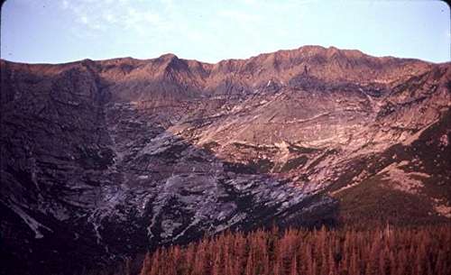
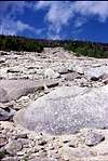
Reverend Marcus Keep opened the route via the Avalanche the east slide ( see the picture). His 1846 first attempt was a partial ascent. In 1847, he succeeded in mid September. Route: Westward from Katahdin Lake across Roaring Brook up Avalanche Brook, North up the slide to Keep Ridge to Pamola and across the Knife Edge. He says that the Avalanche Slide is the result of several slides the last of which was thirty years before his October 1849 letter. His third party(same route) included 5 women including his bride and he concluded the successful ascent with a sermon on top Sunday August 19, 1849.
Remark on the 1849 climb by the Keep party: Shortly before this Mrs. Oakes Smith of Portland Me, was guided this way as far as Pamola where she left a letter in a bottle apparently to taunt Keep insofar as she had beaten Keep's new bride as the first woman to the top of the mountain.
Writers include: Thoreau and Geoffery Winthrop
Artists: (high dollar): Frederick Church and Marsden Hartley- others including John Marin.
Land Barons: Former Gov. Percival Baxter deeded about 200,000 acres to the state of Maine for the park and wildlife refuge.
Trailheads
Park trails are blazed a baby blue except the white blazed Appalachian.Roaring Brook between Turner and Katahdin
Chimney Pond trail westbound 3.3 miles
Helon Taylor Trail to Pamola Southwest 3.2 miles
Sandy Stream Pond and South Turner Northeast (.5 and 2 miles)
Russel Pond northbound 7 miles
Katahdin Stream
Hunt Spur (Appalachian trail finish) northeast 5.2 miles
The Owl-1.1 along hunt to Katahidn falls then a further 2.2 to Owl
Abol campsite
Abol trail to tableland and summit northeast bound 3.8 miles
Foster Field about 2.7 miles northwest of Katahdin Stream
OJI Southslide Trail northbound 2.9 miles
Doubletop South Peak west bound 4 miles (North Peak 4.2 mi)
If you intend to climb Squaws Bosom, pause at the SB Doubletop col and head west into thick spruce/fir.
Slide Dam 5.9 miles north of Katahdin Stream
North Brother: eastbound up the slide: 3.7 miles
Mt. Coe Ascend the Marston trail 1.2 up the big slide, go right .2 miles
to base of Mt. Coe slide and ascend this southfacing slide with OJI at your back 3.3 miles.
Nesowdnehunk Campground: Trail to Doubletop Northpeak starts from southern leandto and is southbound for 3.1 miles
Russell Pond
Roaring Brook is 7 mies south of here
Nothwest Basin Davis Pond is 5.2 miles Soutwest with Hamilin Peak a further
2.1 miles.
Pogy Notch Trail northbound to South Branch ponds 9.7 miles
Wassataquoik Lake(east end) westbound 2.5 miles, Geen Falls 3.3 miles
Newsowdnehunk Lake and road 11.4 miles.
South Branch Campground:( 30 miles north of Katahdin Steam Campground)
North Traveler: 2.5 miles southeast
Traveler- 2.5 miles south of North Traveler 2.5 miles back to Upper South Branch Pond and 2 more miles back to South Branch Campground.
BlackCat Mountain 2.6 miles south southwest of South Branch Campsite.
Russell Pond Campsite 9.7 miles south via Pogy Notch Trail.
Map of Millinocket and Fees
Map of MillinocketThe following is from the Baxter State Park website on Feb. 17, 2006
Millinocket to Togue Pond Gatehouse - 18 miles.
Togue Pond Gatehouse to Greenville via Ripogenus Dam - 70 miles.
Matagamon Gatehouse to Patten via Shin Pond and Route 159 - 26 miles.
To protect the wilderness resource, the park limits access to parking lots/trailheads. Access is based on a first-come, first-served basis; when parking lots fill up, that area is closed. Early arrival is recommended for day-use.
Please help us to protect this area by following Leave-No-Trace guidelines and practicing wilderness ethics in the Park.
CAMPGROUNDS:
There are ten campgrounds located at Roaring Brook, Abol, Katahdin Stream, Nesowadnehunk, South Branch Pond, Trout Brook Farm, Chimney Pond (walk-in), Russell Pond (walk-in), Daicey Pond (cabins only) and Kidney Pond (cabins only). Maps of each campground are provided for your convenience.
The campgrounds have facilities which may vary including leantos, tenting space, bunkhouses, fireplaces and picnic tables.
Canoes are available for rent at South Branch Pond, Russell Pond, Trout Brook Farm, Daicey Pond and Kidney Pond.
Fees
Baxter Park is operated solely through user fees and interest from trust funds provided by Percival Baxter. Baxter State Park receives no tax dollars or other funds from the State of Maine. The Park's goal is to have Trust Funds and other Park Revenue pay 70% of each year's budget, with recreational fees providing the other 30%.
NON-RESIDENT ENTRANCE FEE (Payable only at gate.)
* A day pass or season pass is required for all non-resident vehicles entering Baxter State Park.
* No non-resident motor vehicle shall be permitted to enter the Park without payment of a $12.00 entrance fee per motor vehicle per day.
* A non-resident motor vehicle entering the park with overnight reservations covering one or more successive nights to be spent in the park shall be permitted reentry upon payment of a single entrance fee of $12.00.
* Motor vehicles shall not be permitted to enter the Park under any other circumstances, including day use, through traffic or reservations for non-successive nights in the park, without payment of an entrance fee each day
* A season pass under this regulation shall be available at a charge of $37.00 per non-resident vehicle.
* This regulation shall not apply to motor vehicles bearing a Maine registration and license-plate.
Summer Season Fees
BUNKHOUSE $10.00 per person per night - Reservation is for individual bunk only. Facility is shared with other individuals or groups up to the capacity of the bunkhouse.
LEAN-TOS
[view photo] $9.00 per person per night, minimum $18.00 per lean-to per night
TENTING SPACE
[view photo] $9.00 per person per night, minimum $18.00 per tent site.At TROUT BROOK FARM and NESOWADNEHUNK CAMPGROUNDS there shall be a family rate of $18.00 per site per night
CABINS
[view photo] $25.00 per person per night, minimum $45.00 for a 2-person cabin, $60.00 for a 3-person cabin and $75.00 for a 4+person cabin. Children age 1-6 free, age 7-16: $15.00 per person, subject to minimum total cabin fee. Gaslights and firewood are included in cabin fee
GROUP AREAS $5.00 per person per night, 6 person minimum charge ($30.00). There is no per person charge for children under 7.
Winter Season Fees
BUNKHOUSE**
$18.00 per person per night, except at Chimney Pond bunkhouse is $37.00 per person per night.
LEAN-TOS OR TENT SITE $12.00 per person per night.
CABINS $30.00 per person per night.
**Reservations is for individual bunk only. Facility is shared with other individuals or groups up to the capacity of the bunkhouse.
We accept Visa/Master Card, Bank Checks or Money Orders (NO personal checks for winter camping fees).