
-
 15132 Hits
-
 83.4% Score
-
 17 Votes
|
|
Mountain/Rock |
|---|---|
|
|
39.79990°N / 113.9363°W |
|
|
Hiking, Skiing |
|
|
11588 ft / 3532 m |
|
|
Overview
 Island of red quartzite in the sea of white granites
Double-top Red Mountain is located in the remote Deep Creek Range, near UT-NV state line, across Granite Creek Pass from the better-known, and 500 ft higher, Ibapah Peak. The quartzite-clad Reds provide a perfect visual counrebalance to the white granites of Ibapah, and the North-facing gully between the two summits of the Red Mountain is a great ski descent route in winter / early spring, or a thousand-foot fun of snow glissading through mid-summer.
Both summits of Red Mountain have large cairns built in 1889 by the U.S. first Transcontinental Survey. Somewhat politically incorrect in a typical fashion of the day, the higher-elevation station, on the West summit, is designated "Red Chief" and the 23 ft lower one on the East summit is designated "Red Squaw".
Getting There
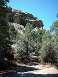 Granite Creek TH
The standard TH is in Granite Creek Canyon, about 15 miles SW of Callao UT. It is very far from everywhere, make sure you've got full tank of gas, water, and a spare tire in good condition.
From Wendover South along SR 93 (28 mi), left to Ibapah Highway (17 mi), left to graded road to Gold Hill (12 mi), left towards Callao.
Callao area can also be reached from Tooele Valley by Pony Express Trail, from IPP blacktop by the way of Sandy Pass, or from State Line gas station on US 6/50 near GBNP.
Marked Granite Cyn turnoff is 13 miles South of Callao Junction on the main graded road to Trout Creek. Take the left fork to head for the canyon mouth (the right fork ends shortly at a ranch). Most cars can make it to the 2nd Granite Creek crossing, with good campsites nearby. The official trailhead is just over half-mile further up the road, and may not be worth taking chances if the 2nd crossing is in poor condition.
For access info for the West Slopes, check Doug Springmeyer's route description for nearby Ibapah.
Routes
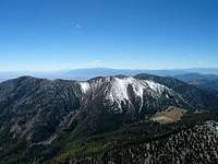 The Reds, dusted with some snow
North Ridge from Granite Creek Pass (or the meadows just East) is the standard ascent. There is no trail but the woods of the lower slopes are open, then there are fields of sharp red talus to which the mountain owes its name.
If there is snow in the North gully separating the two Reds, it offers the best descent option. Use the left (West) lobe of the snowfield if the minor rock belt directly below the saddle is already exposed.