
|
|
Mountain/Rock |
|---|---|
|
|
38.49000°N / 113.9572°W |
|
|
Beaver |
|
|
Hiking |
|
|
Spring |
|
|
9480 ft / 2890 m |
|
|
Overview
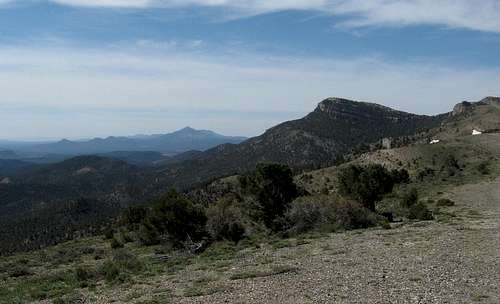
In the Mountain Home range of the western Utah desert, another gem is hiding away. One of the more unknown areas in Utah, this is a very isolated area and when you venture out here, have plenty of gas, food and water. An extra spare tire is a good choice and although 4wd is not absolutely necessary, unless the roads get wet and good ply tires are a must. Needle Benchmark also goes by the name of Mountain Home Range Highpoint so be aware of that little tidbit.The reason this one is interesting to me is because it is one of Utah's
84 prominence peaks, coming in at #57 with 2400 feet of clean prominence.
The closest towns of any size are Ely Nevada and Milford Utah. Milford is the closer of the two so that is what I will refer to.

Getting There
It is roughly 55 miles to the turnoff that you need to find from Milford. I say roughly because I failed to record exact mileage so I have provided maps with GPS waypoints that will aid you in any effort to find theaccess to the route I have provided. The turnoff is just beyond the halfway
summit that is shown on the Benchmark map book, page 64. Ken Jones included this information in his trip report:
Utilizing a virtual milepost of 24.9 (1.1 mi NW of Halfway Summit)
1.6 Bear right
3.7 Approaching corral and tank, turn right (NW)
4.7 "T" intersection, turn left
8.0 Bear left at intersection and drop down, crossing wash
12.0 Turn right onto ridge (mileage could be wrong, sloppy note)
14.8 Park in this vicinity.
You may encounter a guy who seems to camp all summer in this area but just wave and drive as far past his camp to the end of the road.
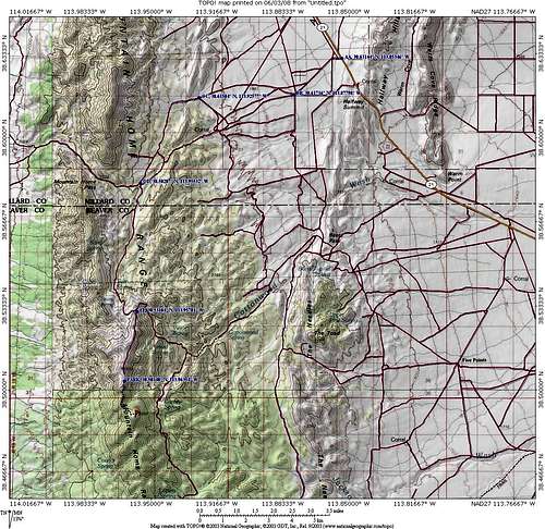
Area map - use the other 4 for more detail
Route and Summit stuff
Route:There are several ways this peak could be accessed but since we did it from the north, that is the way I would use if I were to do this one again. Ken Jones has created a good trip report that covers this route on peakbagger. His route is the same one we used and he has placed his GPS track on peakbagger which should be a nice help to those who are interested in doing this one. If you are interested in this one, check his trip report out.
Stats: Roundtrip hike 3 miles Elevation gain 1000 feet. From the trailhead there is a drop to a saddle but again, see Ken Jones
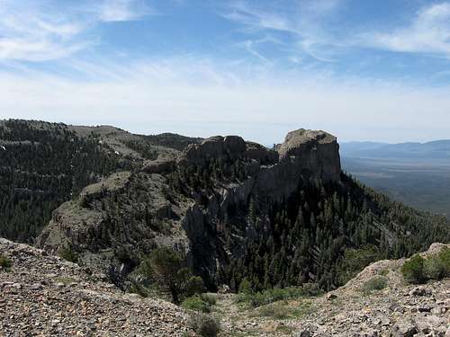
You will find a benchmark and a couple witness markers on the broad shaped summit. Also, a cairn with a register tucked inside awaits the hardy hiker
who ventures this deep into the middle of nowhere (but what a wonderful middle of nowhere). A small bunch of bristlecone pine trees, hundreds of years old are also to be enjoyed.

Great Basin National Park is fairly close.
Milford Utah information

Benchmark
Animals seen on this hike:
Proghorn antelope - est. 22
Wild Horses - est. 12
Snakes - one (generally enough)
Lizards - lots
Ant, bees and no mosquitoes (Yea)
Red Tape
There is no red tape that I am aware of since most of this area is BLM land and is managed by that governmental organization. Having said that, though, let me reprint some information as it pertains to the Wild Horses of the area. The following has a bit of information explaining the names of the ranges as well as about the horse herd."WILD HORSES OF UTAH'S MOUNTAIN HOME RANGE
Ron Roubidoux March 1994
The Mountain Home Range lies at the north end of the Bureau of Land Management's Sulphur Herd Management Area, which is located in southwestern Utah. Craig Egerton, Supervisory Range Conservationist for the BLM's Beaver River Resource Area, says that most maps show the entire north and south running range as the Needle Range, but local people break it up into the Mountain Home Range on the north and the Indian Peak Range on the south. The highest elevation in the Mountain Home Range is 9,480 feet whereas Indian Peak has an elevation of 9,790 feet. The forty mile long Needle Range is covered with heavy stands of pinion and juniper, and is located east of the Nevada-Utah border. Hamblin Valley is on the west, Pine Valley is on the east, and the Escalante Desert is on the south. Antelope Valley, the Burbank Hills, and Great Basin National Park are on the north.
Elevations of the surrounding valley floors are between 5,000 and 6,000 feet. From the dry, lifeless hardpan of the valley floors the land gently rises over native grass covered flats to sagebrush covered benches, and finally to the pinion-juniper covered mountains. Benches and mountains are broken up with many rugged canyons and draws. Low areas are generally sandy while the mountain slopes are very rocky. The Sulphur Herd Management Area is approximately 142,800 acres, and covers the entire Needle\ Range. Most of the area is unfenced.
Gus Warr, Range Conservationist for the BLM's Beaver River Resource Area, says there is an imaginary line between Vance Spring and Sulphur Spring which divides and separates the horses in the Sulphur Herd Management Area. The area between these springs also divides the Mountain Home Range from the Indian Peak Range. Both Craig and Gus have said that most of the Spanish type horses are found north of this line on the Mountain Home Range. The BLM is therefore managing this area specifically for the Spanish type horse. The herd management area gets its name from the Sulphur Springs. There are three springs in all, North Sulphur Spring, South Sulphur Spring, and Sulphur Spring. Many other springs are found throughout the Needle Range. (the full article can be found HERE)
More information can be obtained from the Cedar City office of the BLM.
Cedar City Field Office
176 East D.L. Sargent Drive
Cedar City, Utah 84720
(435) 865-3053
Camping
No campgrounds are to be found in this area but primitive bush camping is allowed when "leave no trace" ethics are followed. Stay on existing roads and make certain campfires are out and no fire rings are left. Best to use self contained stoves. Carry all the water you will need as this area has no lakes, streams or readily available water sources.
Weather - Milford area

Disclaimer
As road conditions can change and hiking, climbing or traveling in this type of country can be inherently dangerous, the above information is provided only as a courtesy. You accept all risk and responsibility for your activities in this area and I recommend that you let others know of your plans and where you will be hiking/climbing prior to heading to this area. Be self sufficient and carry plenty of food, water and shelter in the event of a breakdown. Good quality tires are a necessity on the rough and rocky roads you will encounter as is a vehicle in good condition. Roads may become impassable when wet. Avoid the area during electrical storms and avoid high ridges &exposed areas. Having said all that, have a good trip and please let the author of this page know of changes that you encounter.Please let me know if road conditions or access changes.