
|
|
Mountain/Rock |
|---|---|
|
|
40.24870°N / 112.5428°W |
|
|
Tooele |
|
|
Hiking |
|
|
Spring, Summer, Fall |
|
|
9020 ft / 2749 m |
|
|
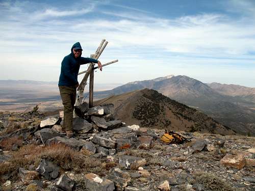
Summit pose
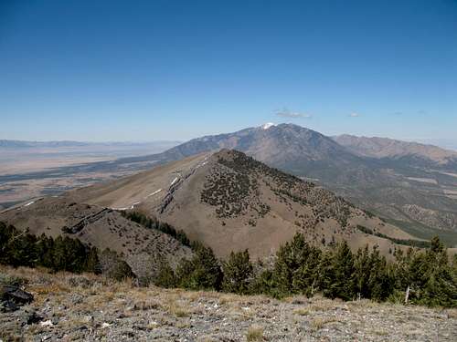
Overview

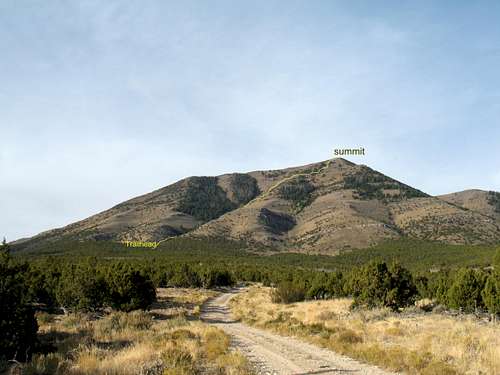
Near trailhead
An out of the way peak that few have heard of and even fewer have visited. However, as the understanding and pursuit of prominence peaks increase, that most likely will change. This is a great change of pace type of peak where the only way to access the summit is to find your way up it via cross country as no trail exists.
Stookey Peak, also referred to as Stookey BM (benchmark) in a few other reference sources is the highest point found in the Onaqui Mountains, located
south of the Stansbury Mountains and Deseret Peak, a more well known area and peak in Utah. Another aspect of this mountain range that does get some attention is the population of wild horses (feral) that consider this area home and is watched over by the BLM. Here is a link to some information on
these horses that you might find interesting. I wish I had seen this information before I headed there as I found a lot of horse scat on my cross country hike which made me realize that there must be wild horses in the area. Yet another link on the horses can be found HERE.
The Onaqui range is not large but Stookey Peak has 2500 feet of prominence which lands it at #42 on the Utah Prominence peak list. For a description of what prominence is, go here.
Here is a bit of the information on prominence from the above linked site:
"Mountain summits have long been known by their elevation above mean sea level. Now a growing community of climbers, mountain enthusiasts and mathematicians recognize that summits can also be measured by their elevation relative to the surrounding terrain. Prominence is the elevation of a summit relative to the highest point to which one must descend before reascending to a higher summit."
Getting There
Looking north

The gate
several vehicles at this spot and across the road on the south side is an obvious camp site.
The road does continue on to Two Springs and I guess you could start the hike from there. When I GPS'd the distance from the parking spot I chose to the summit, it was 1.04 miles, about as close as you will be able to get. I did check that road out and it gets much rougher so I backtracked and parked where I have shown.
It is approximately 11 miles from the highway junction of 36 and 199
As a side note, the original "Pony Express" route ran just to the south of the Onaqui mountains. You can still drive the road that was constructed to follow the original route and might be a worthwhile side trip while you are in the area to climb Stookey.
Route Information
NOTE: The map I've included works best if you click on it twice. From what is added to the map, you will get a good idea of the way in from highway 199. I would refer you now to the map picture here.

343886:alignright:small:
From the parking area, walk down the road to an obvious drainage gully. While no trail exists, it is not difficult to work your way up the hillside following game trails or common sense. It might be easiest to start on the south side of the drainage and then work over to the north side as cliffs will impede easy progress. A natural game trail path led across the drainage and I found that the north side of the drainage (stream during the spring) worked best for me and my route up pretty much paralleled it almost all the way up. Route finding is not difficult (after all I did it didn't I) but it does get steep at time although it never gets technical or beyond class 2 hiking. As the drainage curved up, I followed and having the summit on my GPS aided my direction finding.
When you reach the tree, you are almost there. The tree is an old monarch and I saw no others of its kind. Of course it is now just a shell of its former self but it must have been pretty impressive when it was alive.
Distance: 3 miles round trip. Elevation gain of around 2150 feet.
The summit itself does not seem to have a benchmark and I surmise that the benchmark may be hidden underneath the huge cairn that marks the summit. However, I could find no witness markers so maybe someone reading this blurb will know something that I would appreciate adding here.
 |  |  |
Note: For those who lack a 4wd high clearance vehicle, you could park near the gate and walk up the road. This will of course add distance and elevation gain but it is a reasonable alternative to not having the kind of vehicle that would get you up to the trailhead I've mentioned.
Red Tape and Weather
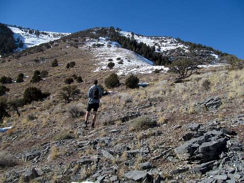
Greg heading up
None that I am aware of. This is on BLM land and I would respect the need to open and close the one gate you will have to pass through.
Tooele is the closest town of any size so it is being used for weather conditions:

Camping
A campground is available on highway 199 before you get to Johnson Pass. . Clover Springs has 11 sites and charges a fee. See below:Description: 6000 ft. elevation. 11 campsites at the northeast end of the Onaqui Mountains. The clear, bubbling waters of a natural spring gave this site its name. Cottonwood trees frame this campground which includes a trailhead for hikers and horseback riders. Group camping is available with a reservation. Additional group camping is available for equestrians.
Location: From Tooele go 15 miles south on UT 36-- turn west at the junction with UT 199 and go west 9 miles on UT 199 to the base of the Onaqui Mountains.
Address: Bureau of Land Management
Salt Lake Field Office
2370 South 2300 West
Salt Lake City, UT 84119 Phone: 801-977-4300
Season: May - November, weather permitting
A fee is charged
Summit time
The popularity of prominence peaks has created a desire for many to find their way to the top of this mountain. Since my first visit in 2007, probably a dozen more have tagged this one. Peakbagger.com has a listing of those who have made the summit but this doesn't include everyone. Another resource is Lists of John and my personal guess for the end of 2014 is probably 24 people who have been to the top. On my first visit, I couldn't find a register but on my second visit two years later I did. Then others have reported that they couldn't find a register when they were there.
For a nice trip report with pictures and maps, check out Eric Willhite's offering HERE.
External Links
Check out this Resource which includes a nice picture of Stookey Peak.Click HERE