
-
 5621 Hits
-
 84.27% Score
-
 18 Votes
|
|
Mountain/Rock |
|---|---|
|
|
39.08370°N / 105.4038°W |
|
|
Park |
|
|
Hiking |
|
|
Spring, Summer, Fall, Winter |
|
|
8906 ft / 2715 m |
|
|
Overview
 Bighorn Sheep are a common site in the Tarryall Valley during snow season
 This poor little peak took a beating in the Hayman wild land fire of 2002. Much of the summit and slopes were scorched in this vast fire which, while improving the distant views from this petite peak, lends an eerie air of death to the visit. Nearly a decade after this devastating inferno, the land has yet to heal; charred wood still turns your hands and clothing black upon contact. Roasted snags of Ponderosa Pine bear witness to human idiocy and the destruction of hot crown-fires in the midst of a regional drought.
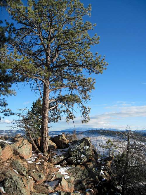
The rocky summit of this petite peak yields delightful views of mountains near and far and is capped by an outsized summit cairn. Far-away views of lonely Pikes Peak mark the southeastern horizon. Soft green views of the rolling 11,000-foot Puma Hills draw the eye northward up the Tarryall Valley. The charred remains of the forest burned by the Hayman Fire stretch out to the northeast, with the pink granite cone of Pilot Peak piercing the devastation.
Colorado Rank*: 2980th highest peak in Colorado
Prominence*: 326 feet
USGS Quad: Tarryall
Trails Illustrated Map: #137 (Pikes Peak, Cañon City)
*Rank and Prominence Reference: Lists of John
Getting There
UN 8906 sits just to the east of Park County 77 in eastern Park County, not far from the border with Douglas and Teller counties. This gentle, low mountain is easily accessible via FS 211. FS 212 is approximately 8 miles north on Park County 77 from Hwy 24 west of Lake George.
Route Information

Route from parking at junction of FS 211 and FS 211A
This route is a super-short but steep outing and the mountain is surprisingly steep and rugged, the southwest slopes studded with outcrops and deadfall.
| Driving Directions From Park County 77 about 8 miles from Hwy 24 near Lake George, follow FS 211 northeast for less than 1 mile to the junction with FS 211A. Turn left/north and follow FS 211A very briefly up a steep hill to a rustic parking area. Roundtrip Distance: 1 mile Elevation Gain: 550 feet |  UN 8906 from the road UN 8906 from the roadBy Jeremy Hakes |
Red Tape
 Pilot Peak from summit area
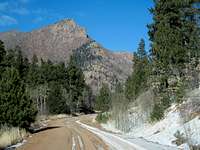 Pilot Peak rising above FS 211
Much of the National Forest access along the Tarryall Valley is characterized by public access easements through private property lining the road/creek. Be respectful of the property rights of the owners who grant us access through their property.
Otherwise, there is little red tape governing recreational use in this part of the National Forest and there is no fee to access this area. Adhere to LNT (Leave No Trace) principals, observe fire ban when in effect and do not harass wildlife or allow your pet to do so.
Camping & Lodging
 This Ponderosa Pine survived the 2002 Hayman inferno
FS 211 and FS 211A and Immediate Surroundings
A few rustic camp sites can be found along FS 211 and FS 211A. These rustic, informal sites are available on a first-come first-served basis. While water is available in the stream paralleling FS 211, given the density of cattle being run in the area, it would be wise to avoid drinking the water in the downstream vicinity, so pack water sufficient for your group size and the duration of your stay.
Designated National Forest Service Sites
The National Forest Service has a large selection of campgrounds in and around the Lake George area.
| Campground Name | Elevation | Sites | Nightly Rate | Reservations? | Notes |
|---|---|---|---|---|---|
| Blue Mountain | 8,200 ft. | 21 | $12 | Yes | Just a couple miles south of Lake George. |
| Spruce Grove | 8,600 ft. | 27 | $12 | No | Let the gurgling Tarryall Creek sing you to sleep. |
| Twin Eagles | 8,600 ft. | 9 | $8 | No | Must haul or purify drinking water. |
| Happy Meadows | 7,900 ft. | 8 | $12 | No | Situated along the South Platte River. |
| Round Mountain | 8,500 ft. | 16 | $12 | Yes | Drinking water, vault toilet and trash pickup. |
| Springer Gulch | 8,300 ft. | 15 | $12 | Yes | Situated within the Elevenmile Canyon; water, tables, fire grates. |
| Riverside | 8,000 ft. | 19 | $12 | Yes | Situated within Elevenmile Canyon; large grassy meadow with little shade. |
Cabins, Lodges and Hotels
Numerous cabins can be rented in and around Lake George. There are also a few cabins/lodges/dude-ranches along the Tarryall Creek catering especially to the fly fishing visitor. For example: Ute River Ranch
Weather & Seasons
 Approaching the summit ridge
 UN 8906 from Tappan Mountain to the east
Summer: The route would be a bit hot and dusty in the summer, but the road should be dry and accessible and the breezes on top pleasant.
Spring: The snowpack is less deep here than in the high country and melts out faster than higher areas to the west. None-the-less, expect post-holing through unconsolidated snow drifts in the trees.
Fall: The aspen coating the slopes of peaks in this area make this area a golden-hued heaven in the fall.
Winter: Thanks to proximity to Park County 77, this peak is accessible year-round, though deep snows/drifts and 4x4 road closures could add a couple miles to the roundtrip journey to the summit of this peak and back to your parking.
 Moonrise near the summit