
-
 8505 Hits
-
 86.85% Score
-
 23 Votes
|
|
Mountain/Rock |
|---|---|
|
|
41.54764°N / 122.26238°W |
|
|
Siskiyou |
|
|
Hiking |
|
|
Spring, Summer, Fall, Winter |
|
|
4248 ft / 1295 m |
|
|
Overview
 Yellow Butte from the route to the summit
The Shasta Valley spreads out to the north of Mount Shasta. In contrast to the lush alpine forests surrounding the grand volcano, this area is the home of the juniper and sagebrush, making it more akin to the dry, east side of the Cascades in Oregon or the deserts of the Great Basin. Situated at the fringe of these two climates is Yellow Butte, one of several buttes of color that surround Mount Shasta. The only one of these buttes on the north side of the mountain, Yellow Butte is an often seen but seldom traveled peak. The butte is prominently visible from all over the Shasta Valley and particularly conspicuous from Highway 97, which travels directly beneath it. Nonetheless, it generally escapes notice, not because it lacks interesting features, but because it is hopelessly overshadowed by the mysterious Sheep Rock, the Whaleback and, of course, the grand cone of Mount Shasta. Nonetheless, Yellow Butte is an oasis for the outdoor adventurer when the rest of the Mount Shasta area is covered in snow.
 Mount Shasta from the summit of Yellow Butte
The Shasta Valley lies in Mount Shasta’s rainshadow, an area of significantly reduced rainfall caused by the proximity to a major mountain feature. As storm systems pass over Mount Shasta, the moisture is pulled out of the storm. Once past the mountain it does not have much moisture left to contribute significant precipitation to the area. Thus, the Shasta Valley is a high desert. The Valley is marked by Mount Shasta at its southern end. The Klamath Mountains, particularly the Scarface Mountains, mark the western boundary while the Cascade crest composes the eastern wall. The Klamath River, Black Mountain and Paradise Craggy form the northern perimeter of the Valley. The Shasta River drains the whole area. While the valley is generally flat, there are a significant number of hills and small mountains in the center of the valley. These were formed by an ancient rockslide off of Mount Shasta. Yellow Butte, and its close neighbor, the Haystack, are outliers, being much further to the east the rest of the cluster of hills. Moreover, they are created by volcanic activity. The surrounding lava flows and the cinder quarry are evidence that these small mountains are the result of volcanic activity rather than a rockslide.
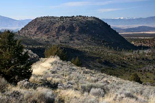 The Haystack and the Marble Mountains from Yellow Butte
Yellow Butte gets its name from the generally dried grasses that cover the mountains flanks, giving it a distinctly yellow appearance. This is in contrast to the other four color-themed buttes around Mount Shasta, all of which get their names from the color of the stone that composes them. Yellow Butte is a linear mountain, running along a north-south axis. The highpoint is at the northern end. The southern end of the butte has two smaller summits, which are separated from the highpoint by a saddle.
Like most of the peaks in the area, the summit views are outstanding. Mount Shasta is the obvious monarch of the perspective, lying only 10 miles away and 10,000 feet overhead. To the southeast, the Whaleback looms large while Ash Creek Butte peers over its shoulder. Herd Peak and the mysterious walls of Sheep Rock constitute the horizon. The Shasta Valley spreads out to the north, Pilot Rock, Mount Ashland and the Siskiyou crest in Oregon being clearly visible. To the west, the Marble Mountains and the Russians rise above Scarface Ridge while further south Mount Eddy and China Mountain are visible in the distance, beyond the Haystack.
Route
 Herd Peak and the Sheep Rock from the route to the summit
The route to the summit of Yellow Butte is an old, easily followed dirt road. Generally two-track, the road sees little use. From the small pullout off of Highway 97, pass through the gate and follow the road for 1.3 miles to the summit. The road passes two saddles where it is possible to climb lower points along the crest of Yellow Butte, as well as to descend down to the Juniper Flats via rough 4x4 roads. The last 0.25 miles to the summit are the steepest section of the route. While it is possible to drive to near the top of Yellow Butte, it is a much more pleasurable proposition to hike to the summit.
Yellow Butte Maps
Yellow Butte Area Map
 Yellow Butte area
Yellow Butte Route Map
 Yellow Butte route
Camping
 Looking west toward the Haystack and Mount Eddy
The closest campground is located at Lake Shastina. To get there from Yellow Butte, head west on Highway 97 for 6.5 miles and turn right on Big Springs Road. After 1.7 miles turn left on Jackson Ranch Road. Drive 1.0 miles and turn right on Dwinell. Follow the road to the campground on the lakeshore.
Dispersed camping is allowed throughout the area surrounding Yellow Butte, particularly to the south of Highway 97.
Getting There
From downtown Weed, drive east on Highway 97 for 11 miles. A small dirt road blocked by a green gate will be on the left. Park next to the gate. 9.5 miles from Weed, Highway 97 crosses over usually dry Whitney Creek. Visible ahead is the Haystack with Yellow Butte beyond. The dirt road is 1.5 miles beyond Whitney Creek. Be sure to close the gate at the beginning and end of the hike to Yellow Butte.Red Tape
 The view north, into the Shasta Valley and beyond
The road accessing Yellow Butte is on Forest Service land but passes through private lands en route to the summit. Though there seems to be unhindered access to the butte, please be sensitive to property rights when passing through private lands.
Although Yellow Butte's proximity to Mount Shasta would lead one to assume it is in the Shasta-Trinity National Forest, it is in fact on the Klamath National Forest, which manages the Forest Service lands north of Highway 97.
Klamath National Forest
1312 Fairlane Road
Yreka, CA 96097-9549
(530) 842-6131
Goosenest Ranger District
37805 Highway 97
Macdoel, CA 96058
(530) 398-4391