
-
 5058 Hits
-
 81.02% Score
-
 13 Votes
|
|
Mountain/Rock |
|---|---|
|
|
46.84352°N / 9.03701°E |
|
|
Hiking |
|
|
Summer, Fall |
|
|
9698 ft / 2956 m |
|
|
Overview
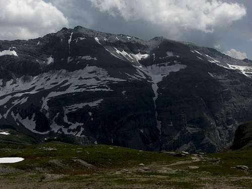
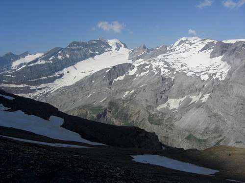
Muttenbergen as seen from Muttsee
Between huge Muttenstock to the north and Piz d´Artgas to the south, which dominates the valley of Brigels/Breil, there is a nearly 1 km long ridge, culminating at 2956 m. This ridge and its culmination point is called Muttenbergen.
Muttenbergen is a frontier summit between Glarus and Graubünden, separating the Limmeren valley with the Limmeren dammed lake to the west from a huge hanging valley, called Cavorgia da Vuorz, to the east.
As Muttenbergen is located so conveniently 250 m above the well known route from Muttseehütte to Bifertenhütte, this short detour should be nearly a must for passers-by. Nevertheless not many people seem to visit this summit as the summit foot track is narrow, steep, indistinct and marked only with sparse cairns.
After the Hausstock / Ruchi day in july 2013 I found it quite entertaining to summit Muttenbergen on the morning of the next day – good views to Bifertenstock, Sebsanft and Tödi – before returning to Tierfehd and Linthal. That can be another opportunity to visit this lonely summit ridge.
Getting There
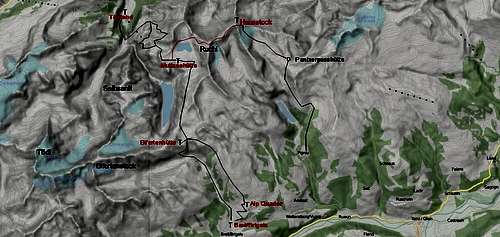
Muttenbergen trailheads
Powered by Leaflet | Map data Ⓒ OpenStreetMap contributors, CC-BY-SA
Valley trailheads for Muttenbergen are
By car
You reach Linthal on road number 17 from Altdorf / highway number 2, Luzern - Bellinzona via Klausenpass or from highway number 3, Sargans - Zürich, exit “Niederurnen” via Glarus.
At Linthal follow the narrow road to Tierfehd, which branches off at a rectangular bend of road number 17 in Linthal center (called Dorfstraße).
At the end of the road are some (in 2013 still free) parking areas.
You reach Brigels/Breil on road number 19 from Andermatt via Oberalppass or from Chur until you reach the village of Danis / Tavanasa. Turn there on the short road up to Brigels/Breil. Park your car best at the cablecar valley station near the Lag da Breil (Breil lake).
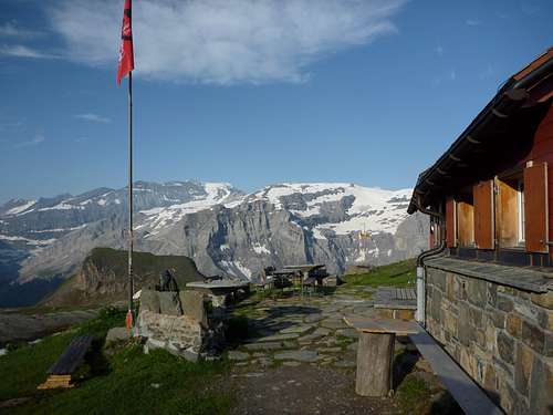
Muttseehütte
By train and/or bus
The nearest railway station to the north is Linthal. Check the SBB schedule here.
Taxi busses can be hailed for a quick drive to Tierfehd (1,5 hours walk by foot).
Tavanasa is the nearest southern railway station (Oberalp Bahn from Andermatt / Disentis-Muster or from Scuol / Tarasp). Check the SBB schedule here
Brigels/Breil can be reached by bus from the railway station Tavanasa.
Main Routes Overview
Summit routes overview
Hut ascents
The main mountain trailheads for Muttenbergen are Muttseehütte or Bifertenhütte.
Muttseehütte ascent
From Tierfehd follow the forest road in direction of Fridolinhütte and Planurahütte until you reach the huge bridge “Pantenbrugg”. One switchback above Pantenbrugg turn left on the narrow trail to Muttseehütte. Ascend this trail until you reach the meadows of “Baumgarten” to a marked trail junction. From there you have two alternatives:
- Turn right on a trail leading up to the mountain station of Tierfehd – Chalchtrittli cablecar. At the station follow the steep and spectacular trail (secured with some iron chains) to Chalchtrittli and Nüschenegg.
- Go straigt on and ascend steeply the meadow slope up to “Tor”, a rock feature on the west slopes of Nüschenstock. Traverse these west slopes until you reach Nüschenegg an the trail junction with the trail from Chachtrittli.
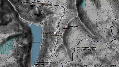
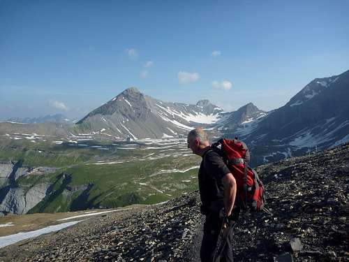
 Muttenbergen and ascent to Kistenpass |  Limmeren dammed lake |  Kistenpass hut |
Enter the huge Nüschen cirque and ascend the broad trail up steep Muttenwändli until you arrive the western rim of Muttsee plateau. Descend slightly on a trail to the already visible Muttseehütte.
This long and demanding ascent can be shortened by using the Tierfehd – Chalchtrittli cableway. This cable car, primarily in use for the water power plant and the workers of the Muttsee construction site, can be used by hikers, too. See the schedule here.
From the mountain station follow the trail to Nüschenegg and Muttseehütte as described above
 Kistenpass signpost, start of summit route |  Approaching Muttenbergen summit |  Pencil slates |
Bifertenhütte ascent
From Brigels/Breil follow the forest road to Alp Quader (taxi shuttle available to shorten the long ascent!) and then the trail to Bifertenhütte. At the lower end of the huge Cavorgia da Breil cirque turn left at a trail junction, go southwest to the nearby Bifertenhütte.
Summit Routes
Summit route from Muttseehütte
Starting at Muttseehütte follow the eastern marked trail first descending about 120 m into the depression of the Muttseeplateau below Muttenstock (point 2388 m on the Swiss topo map).
Ascend again and traverse on snow or the foot trachs the western slopes of Muttenstock and Muttenbergen until you reach point 2729,5 m of the Swiss topo map.
There is a signpost, indicating directions to Muttseehütte, Bifertenhütte and Kistenpasshütte. The latter is located some 20 m below the signpost on a ledge of the very steep rock face, dropping down nearly 900 meters to Limmeren lake.
The signpost says you are at Kistenpass. However, on the Swiss topo map, scale 1 : 25.000, Tödi, Kistenpass is marked more in the south, so that can be a bit confusing.
 Muttenbergen and Muttenstock summit |  Muttenbergen south ridge |
Nevertheless leave the trail at the signpost to your left, look out for cairns and some foot tracks and ascend a cirque on the west slopes of Muttenbergen. Follow the foot tracks near the upper end of that cirque to the north and gain the south ridge of Muttenbergen. Follow this ridge easily up to the inventive summit cairn.
Summit route from Bifertenhütte
Follow the trail in northeastern direction to Muttseehütte. Pass by point 2640 m, which is called Kistenpass on the Swiss topo map and continue to point 2729,5 m, which is indicated as “Kistenpass” on the signpost.
Turn right on the cairned route to Muttenbergen as described above.
An alternative is to follow the whole south ridge starting at point 2640 m (Kistenpass on the Swiss topo map) and following mainly the ridge crest; this requires some UIAA grade I / II- scramble.
Red Tape & Accommodation
Bifertenstock and Selbsanft as seen from Kistenpass ascent
The area around Muttsee is a nature protection site of Kanton Glarus, the regulations say not to leave the marked route. I respected this regulation despite of the construction site which lays partly within the site. The chief geologist of the construction site explained us during some evening beers that renaturation has high priority after the work is finished. Let us hope that the fragile protection site with its beautiful plants and flowers will survive and improve again.
You find accommodation at:
Mountain huts:
Gear & Mountain Condition
Trail to Kistenpass with Muttsee plateau and Nüschenstock
Muttenbergen is an easy summer and autumn hiking mountain.
The route from Muttseehütte and Bifertenhütte is easy; you use the marked and well maintained traverse route from Muttseehütte to Bifertenhütte until you reach Kistenpasshütte. From there on the route is sparsely marked with cairns and in parts steep.
You need full hiking gear and good shoes.
Current Weather for Linthal:
Current weather for Breil:
Maps & Guide Books
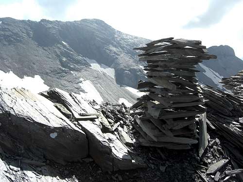
Muttenbergen inventive summit cairn
Maps
Landeskarte der Schweiz, scale 1 : 25.000, number 1193, Tödi, 2005
Guide Book
Schweizer Alpen Club: Hansueli Rhyner, Ruedi Jenny, Samuel Leuzinger, Glarner Alpen, Alpine Touren, 2013
Bergverlag Rudolf Rother, München: Ulrich Tubbesing, Gebietsführer Glarner Alpen, last edition 1991, out of print (try it with antiquarian booksellers)