
-
 7299 Hits
-
 80.25% Score
-
 12 Votes
|
|
Mountain/Rock |
|---|---|
|
|
49.07913°N / 7.75106°E |
|
|
Sport Climbing, Scrambling |
|
|
Spring, Summer, Fall |
|
|
935 ft / 285 m |
|
|
Overview
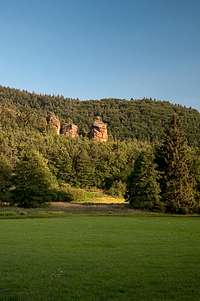
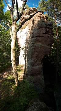
 Ottoturm seen from the south-west Ottoturm seen from the south-west |
There are several mountains in the Südpfalz Region bearing the name Adelsberg. They are more or less distributed across the whole area and all of them host a climbing cliff, called Adelsfelsen. The most important of these, also the most beautiful one, can be found between the villages of Rumbach and Schönau close to the southern boundary of the region, the German - French border. This incarnation of Adelsfelsen consists of four formations, located on the western ridge of the Kleiner Adelsberg mountain.
 |  |  |
Formation number one is Adelsnadel, a slim needle-like tower (therefore the name) which resembles a chalice. For many visitors it is the most elegant of towers in the Südfalz Area and competition is tough. Consequently it was home of another tough competition, the first ascent, which two pairs of brothers fought out. As early as 1913 Fritz and Theo Mann tried climbing the tower but were defeated at each attempt. Finally they climbed neighbouring Kanapee, threw a rope with the help of which they reached the summit. The first fair ascent of the mountain was performed by Otto and Wilhelm Mattheis in 1921.
 |  |  |
The second formation is Kanapee, a lower and wider tower. Its first ascent was performed by Fritz and Theo Mann, who jumped from neighbouring Ottoturm (on their way to throw the rope to Adelsnadel?). Again, the first bottom-up ascent was done by Otto and Wilhelm Mattheis in 1924.
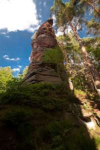 |  |  |
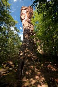
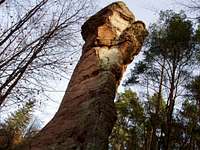
Formation the third: Ottoturm. It is similar to Adelsnadel but since its base is higher up on Kleiner Adelsberg, its height is lower. Here the Mann brothers were successful in 1913, establishing the 4- route to the top. Today's normal route is a 3+ located to the east. Again, one of the routes is a jump down from the massif in the east.
 |  |  |
The Massif is connected to Kleiner Adelsberg on its eastern side so that its normal route is a grade 1 scramble across a ledge in the north face and a final push from the north-west. There are additional grade 2 routes through the north face but most climbers go for the two 6+ woutes Nordwestkante and Westwändel
Climbing Routes on Adelsfelsen
 Ottoturm Erstersteigerweg
Given the fact that the formations on kleiner Adelsberg are so beautiful and impressive it is astonishing how few routes exist. Still, the list of first ascensionists reads like a who is who in Südpfalz climbing, distributed across all the decades of climbing in the area: Fritz and Theo Mann, Ludwig Mann and Jakob Otto, Otto and Wilhelm Mattheis, Hans Laub and Fred Frey, Jörg Brutscher, Udo Daigger. Most coveted are the gig routes on Adelsnadel, starting with the normal Route, Große Südwand and Talwand. The most difficult is Daedalus (9).
| Feature | Routes link | Summary |
| Adelsnadel | Adelsnadel | 6 routes ranging from 5+ - 9 |
| Kanapee | Kanapee | 6 routes ranging from 1 - 7- |
| Ottoturm | Ottoturm | 10 routes ranging from 3+ - 7 |
| Massif | Massif | 5 routes ranging from 1 - 6+ |
Getting There
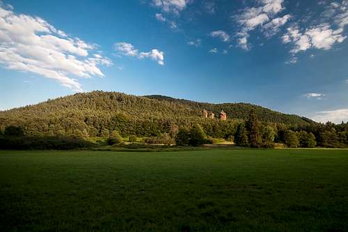 Kleiner Adelsberg
Adelsfelsen is located close to the German-French border in an area, which is not very easily accessible. Itineraries tend to be quite long.
From Frankfurt
There are two possible routes which both take equally long- Via Ludwigshafen
- From Frankfurt take motorway A5 southward to Darmstadt.
- There change to A67 south.
- At Viernheimer Dreieck turn onto A6 west. Leav
- e it at Frankenthaler Kreuz for A61 south.
- At Mutterstädter Kreuz take A65 south until you reach Landau.
- At Kandel turn onto B427 west.
- After Busenberg turn onto L489 to Bundenthal
- At Bundenthal torn onto L478 to Rumbach
- The Adelsfelsen are located directly north-east of the intersection with L488 to Schönau
- Via Kaiserslautern
- From Frankfurt take motorway A3 west
- At Mönchhofdreieck turn onto A67 south
- At Rüsselsheimer Dreieck take A60 west
- At Kreuz Mainz Süd take A63 south
- At Kreuz Kaiserslautern turn onto A6 west
- At Kreuz Landstuhl turn onto A62 south
- At Pirmasens turn onto B10 east
- At Hinterweidenthal turn onto B427 south
- Behind Reichenbach turn onto L489 to Bundenthal
- At Bundenthal torn onto L478 through Rumbach
From Stuttgart
- Take motorway A8 to Karlsruhe
- At Karlsruher Dreieck turn north onto A5
- Take the next exit to head for A65
- At Kandel take B9 south
- At Lauterburg take D3 through Wissembourg to Lembach and Hirschthal
From Strassbourg
- Take motorway A4 north
- At the Brumath Intersection take N340to Haguenau
- There take D27 / L488 north to Lembach, Hirschthal and Schönau
- A little beyond there is the intersection with L478 where you can find the formations
Red Tape
The sandstone of Südpfalz forms lots of caves and overhangs. Though this makes it most interesting for climbers, two species of birds of prey compete for this habitat: the peregrine falcons and the eagle owls. Both are endangered and wherever there is a eagle owl pair found nesting in the sandstone the crag will immediately be closed. Generally this closure lasts from the beginning of each year through Aug. 1st. If breeding is not successful the closures will be cancelled even before that date. For a list of closures see the Closure List of PK.The use of magnesia is not allowed in the whole Südpfalz region. This is rather a directive or an arrangement than an outright law. Thus you probably will get away with using it but do so only when absolutely necessary. Magnesia closes the pores which you find in the sandstone and together they form a smooth surface which will get very slippery in wet conditions. The rule of thumb is to use magnesia in the highest difficulty sections and only extremely sparingly.
A list of guidelines can be found here (in German).
Accommodation
The closest town of importance is Wissembourg / Weißenburg on the French side of the border. The closest town on German side is Bad BergzabernWeather Conditions
Maps & Books
Maps
As for maps there is a good overview map (1:50000) by Kompass Verlag but the best ones are the official topographic maps by the state government of Rheinland Pfalz, scaled 1:50000, 1:25000 and 1:5000. All official maps can be found on the web page of Landesvermessungsamt Rheinland Pfalz
1:50000
- Naturpark Pfälzer Wald
Kompass Map WK766
ISBN: 3-85491-523-3
- Bad Bergzabern
LVA RLP Map L6912
ISBN: 3-89637-194-0
1:25000
LVA RLP Map 6913
ISBN: 3-89637-153-3
Books
There are a number of climbing guidebooks on the region of Südpfalz. The best ones, however, have been published privately and are sold only in selected bookshops of the region.
- Hiking
- Pfälzerwald
B. & J.-Th. Titz
Rother Verlag
ISBN: 3-7633-4268-0 - Klettern im Buntsandstein
U. Daigger, H.-J. Cron
Westpfälzische Verlagsdruckerei St. Ingbert
ISBN: 3-00-0155457-4
- Pfalz - Klettern im Buntsandstein des Pfälzer Felsenlands
J. Richter, S. Tittel
Panico Alpinverlag
ISBN: 978-3-936740-41-7
- Pfalz ++, Klettern im Buntsandstein
R. Burkard, P. Weinrich
Published privately
- Klettern im Naturpark Pfälzerwald
Naturfreunde Lambrecht
Published privately - Pfalz & Nordvogesen en bloc
A. Wenner, Y. Corby, I. Bald
Panico Verlag
ISBN: 3-936740-19-4
  Climbing Guidebook |
Climbing