
-
 5669 Hits
-
 82.71% Score
-
 16 Votes
|
|
Mountain/Rock |
|---|---|
|
|
49.18019°N / 7.90747°E |
|
|
Sport Climbing, Bouldering |
|
|
Spring, Summer, Fall, Winter |
|
|
1312 ft / 400 m |
|
|
Overview
 Katzenfels east face Katzenfels east face |
Katze, Kater, Maus - Cat, Tomcat and Mouse - are the names of three sandstone rocks near the town of Lug in the Wasgau climbing region. They are perfectly aligned, one behind the other, near the summit of Heischberg, a forested mountain between Lug and Völkersweiler. The mountain hosts a number of other cliffs, most notably Wernersberger Geiersteine in the east and Hornsteine to the west. In fact all three formations are located on the same ridge in a straight line and at almost equal distances from each other.
While the Geiersteine crags with their many long routes see most climbing traffic and the Hornsteine - thanks to their close location to the town of Lug draw most visitors, the Katerfelsen are quite secluded and hidden deep in the forest of Heischberg. They are comparatively small - the highest rock, Katerfels, measures little more than 20m - and thus generally serve only as substitutes when the other formations are too crowded. Moreover, boulderers often make the trip to the Heischberg summit to offer the many bouldering problems of the Trio. The westernmost crag officially is called Katerfels, Nebengipfel (side summit) but among climbers is know as Katze. The central summit is Katerfels proper, the highest of the trio, while tiny 6m tall mouse is hidden some 20m east of the rest of the formation. Kater and Katze are standalone towers while Maus could rather be described as a small mushroom, a pillar with a flat, table-like top. All three rocks stand on narrow pillars with overhangs a little above the ground.
|


Climbing and Bouldering on the Katerfelsen / Maus Trio
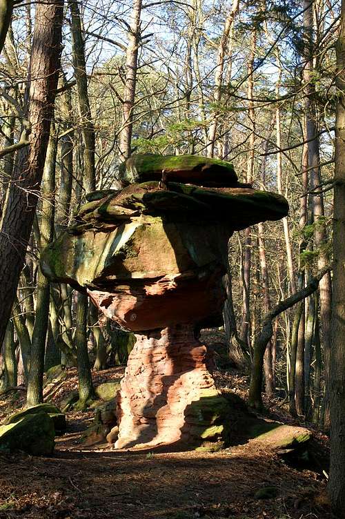 The Maus boulder
Maus is a popular boulder with a a couple of problems. The Katerfelsen offer some short routes and generally serve as a substitute for climbing on Wernersberger Geiersteine east of them. The routes are short sports climbs which might also be rated long bouldering problems
The following information is linked from the site of the Vereinigung Pfälzer Kletterer I link to their routes database directly with some summary info. Here is the link to the complete database.
For more information see the book by U. Daigger and H.-J. Cron (see below)
| Region | Routes link | Summary |
| Maus | Maus as a boulder has no route on the PK Page | 6 different bouldering problems |
| Katerfelsen, Hauptgipfel | Katerfelsen Hauptgipfel | 5 routes with lots of variations 3- - 7, several bouldering problems |
| Katerfelsen, Nebengipfel (Katze) | Katerfelsen Nebengipfel (Katze) | 7 routes 1 - 6, several bouldering problems |
Getting There
 Katerfels west face
The Katerfelsen are located between the villages of Lug and Völkersweiler, quite close to the highway L495. There is a parking lot on L495, close to the highest point between the two villages. If it is too crowded there is another one hidden between the trees on the other side of the road.
From Frankfurt
There are two possible routes which both take equally long- Via Ludwigshafen
- From Frankfurt take motorway A5 southward to Darmstadt.
- There change to A67 south.
- At Viernheimer Dreieck turn onto A6 west.
- Leave it at Frankenthaler Kreuz for A61 south.
- At Mutterstädter Kreuz take A65 south until you reach Landau.
- At Landau turn on B10 west.
- Take the exit Annweiler North after you have passed the second tunnel on the road.
- Take B48, direction Wernersberg and follow it past the village to the intersection with K494 to Völkersweiler
- Just before you reach the village turn onto L495 direction Lug
- Via Kaiserslautern
- From Frankfurt take motorway A3 west
- At Mönchhofdreieck turn onto A67 south
- At Rüsselsheimer Dreieck take A60 west
- At Kreuz Mainz Süd take A63 south
- At Kreuz Kaiserslautern turn onto A6 west
- At Kreuz Landstuhl turn onto A62 south
- At Pirmasens turn onto B10 east
- Take the Hauenstein exit and drive along L495 to Lug and further on to Völkersweiler.
From Stuttgart
- Take motorway A8 to Karlsruhe
- At Karlsruher Dreieck turn north onto A5
- Take the next exit to head for A65
- At Landau turn on B10 west.
- Take the exit Annweiler North after you have passed the second tunnel on the road.
- Take B48, direction Wernersberg and follow it past the village to the intersection with K494 to Völkersweiler
- Just before you reach the village turn onto L495 direction Lug
Red Tape
Yes, there is red tape and lots of it. The sandstone of Südpfalz forms lots of caves and overhangs. Though this makes it most interesting for climbers, two species of birds of prey compete for this habitat: the peregrine falcons and the eagle owls. Both are endangered and wherever there is a eagle owl pair found nesting in the sandstone the crag will immediately be closed. Generally this closure lasts from the beginning of each year through Aug. 1st. If breeding is not successful the closures will be canceled even before that date. For a list of closures see the Closure List of PK.The use of magnesia is not allowed in the whole Südpfalz region. This is rather a directive or an arrangement than an outright law. Thus you probably will get away with using it but do so only when absolutely necessary. Magnesia closes the pores which you find in the sandstone and together they form a smooth surface which will get very slippery in wet conditions. The rule of thumb is to use magnesia in the highest difficulty sections and only extremely sparingly.
A list of guidelines can be found here (in German).
Accommodation
The following accomodation link offers hotels in the larger region (50km circle).- Accommodation:
Lug information
Weather Conditions
The closest available weather information is the one for Pirmasens (40km to the north-west):Pirmasens weather
Maps & Books
Maps
As for maps there is a good overview map (1:50000) by Kompass Verlag but the best ones are the official topographic maps by the state government of Rheinland Pfalz, scaled 1:50000, 1:25000 and 1:5000. All official maps can be found on the web page of Landesvermessungsamt Rheinland Pfalz
1:50000
- Naturpark Pfälzer Wald
Kompass Map WK766
ISBN: 3-85491-523-3
- Bad Bergzabern
LVA RLP Map L6912
ISBN: 3-89637-194-0
1:25000
Books
There are a number of climbing guidebooks on the region of Südpfalz. The best ones, however, have been published privately and are sold only in selected bookshops of the region.
- Hiking
- Pfälzerwald
B. & J.-Th. Titz
Rother Verlag
ISBN: 3-7633-4268-0 - Klettern im Buntsandstein
U. Daigger, H.-J. Cron
Westpfälzische Verlagsdruckerei St. Ingbert
ISBN: 3-00-0155457-4
- Pfalz ++, Klettern im Buntsandstein
R. Burkard, P. Weinrich
Published privately
- Klettern im Naturpark Pfälzerwald
Naturfreunde Lambrecht
Published privately - Pfalz & Nordvogesen en bloc
A. Wenner, Y. Corby, I. Bald
Panico Verlag
ISBN: 3-936740-19-4
Climbing