
-
 5879 Hits
-
 81.74% Score
-
 14 Votes
|
|
Mountain/Rock |
|---|---|
|
|
49.17668°N / 7.97195°E |
|
|
Hiking, Sport Climbing, Toprope, Scrambling |
|
|
Spring, Summer, Fall, Winter |
|
|
1480 ft / 451 m |
|
|
Overview
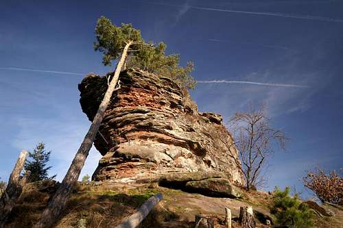 Kleiner Hahnstein south-west face Kleiner Hahnstein south-west face |
In the south of the Annweiler Region of the Südpfalz climbing area, high above the village of Waldhambach you can find two climbing crags, Großer und Kleiner Hahnstein. Both are separated by a distance of about one kilometre with Großer (big) Hahnstein towering directly above the village while Kleiner (little) Hahnstein resides right on the top of the likewise called mountain. It (the latter) is a small climbing crag with an attitude, easy to get to via the normal route but with short and nasty overhanging sports climbs along the south face.
The cliff is located far from the closest parking lot which ensures that you will have it for your own. It also is a little bit difficult to get to as several hiking paths lead in its general direction. Only one of these leads to the crag in question and if you don't take care you might end up in the village of Waldhambach 250 below the crag. Kleiner Hahnstein has a beautiful summit mushroom high above the south face. It is the "crux" of the normal route, thanks to its overhangs which have to be overcome from any side.
The general direction of the cliff is east-to west with the summit mushroom towering in the east. The south face offers several nice and tricky routes, especially in the south-eastern corner of the crag, where the summit mushroom slightly overhangs the face. The east and west faces are well structured and easy to climb while the north face offers the easiest access along a natural staircase. The summit of Kleiner Hahnstein is overgrown by grass and moss (take care in wet conditions) and several small beech trees grow in its western part. The crag is ideal for beginners and offers good opportunities for climbing families with kids.
|


Climbing Routes on Kleiner Hahnstein
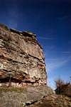
 Kleiner Hahnstein south face
Kleiner Hahnstein is a perfect climbing location for beginners. The routes are short with the easiest one a mere UIAA I scramble. Also, the long access hike ensures that you won't be challenged by unqualified onlookers. The following information is linked from the site of the Vereinigung Pfälzer Kletterer I link to their routes database directly with some summary info. Here is the link to the complete database.
For more information see the book by U. Daigger and H.-J. Cron (see below)
| Region | Routes link | Summary |
| Kleiner Hahnstein | Kleiner Hahnstein | 11 routes ranging from 1 - 5+ |
Getting There
Kleiner Hahnstein is located between the villages of Bindersbach (north) and Waldhambach (south). It can be reached most easily from the parking lot south of Scharfenberg Castle, right beside the road from Annweiler to Trifels. Access from Waldhambach means climbing all the way from the village at 250m to the crag at 450m.The closest airports are the ones in Frankfurt and Stuttgart with the following itineraries:
From Frankfurt
There are two possible routes which both take equally long- Via Ludwigshafen
- From Frankfurt take motorway A5 southward to Darmstadt.
- There change to A67 south.
- At Viernheimer Dreieck turn onto A6 west.
- Leave it at Frankenthaler Kreuz for A61 south.
- At Mutterstädter Kreuz take A65 south until you reach Landau.
- At Landau turn on B10 west.
- Take the exit Annweiler North after you have passed the second tunnel on the road.
- Take B48 south but after 200m leave to the left, driving into the outskirts of Annweiler.
- After another 300m turn right (sign Trifels) and follow the side road towards the castle. You'll pass Asselstein and Kletterhütte (parking lot), then head on for anothe 1.5km. Where the road turns into a one way road there is a small parking lot.
- Via Kaiserslautern
- From Frankfurt take motorway A3 west
- At Mönchhofdreieck turn onto A67 south
- At Rüsselsheimer Dreieck take A60 west
- At Kreuz Mainz Süd take A63 south
- At Kreuz Kaiserslautern turn onto A6 west
- At Kreuz Landstuhl turn onto A62 south
- At Pirmasens turn onto B10 east
- Take the exit Annweiler North and follow the instructions above (sign Trifels)
From Stuttgart
- Take motorway A8 to Karlsruhe
- At Karlsruher Dreieck turn north onto A5
- Take the next exit to head for A65
- At Landau turn on B10 west.
- Take the exit Annweiler North after you have passed the second tunnel on the road.
- Follow the signs "Trifels" until the road turns into a one way road. Use the parking lot there.
Red Tape
Yes, there is red tape and lots of it. The sandstone of Südpfalz forms lots of caves and overhangs. Though this makes it most interesting for climbers, two species of birds of prey compete for this habitat: the peregrine falcons and the eagle owls. Both are endangered and wherever there is a eagle owl pair found nesting in the sandstone the crag will immediately be closed. Generally this closure lasts from the beginning of each year through Aug. 1st. If breeding is not successful the closures will be cancelled even before that date. For a list of closures see the Closure List of PK.The use of magnesia is not allowed in the whole Südpfalz region. This is rather a directive or an arrangement than an outright law. Thus you probably will get away with using it but do so only when absolutely necessary. Magnesia closes the pores which you find in the sandstone and together they form a smooth surface which will get very slippery or soapy in wet conditions. The rule of thumb is to use magnesia in the highest difficulty sections and only extremely sparingly.
Accommodation
There are quite a number of hotels, inns, apartments to be found in the area around Annweiler and Trifels. A good link (German, however) can be found here:Weather Conditions
Maps & Books
Maps
As for maps there is a good overview map (1:50000) by Kompass Verlag but the best ones are the official topographic maps by the state government of Rheinland Pfalz, scaled 1:50000, 1:25000 and 1:5000. All official maps can be found on the web page of Landesvermessungsamt Rheinland Pfalz
1:50000
- Naturpark Pfälzer Wald
Kompass Map WK766
ISBN: 3-85491-523-3
- Annweiler am Trifels
LVA RLP Map L6712
ISBN: 3-89637-191-6
1:25000
- Annweiler am Trifels
LVA RLP Map 6713
ISBN: 3-89637-141-X
Books
There are a number of climbing guidebooks on the region of Südpfalz. The best ones, however, have been published privately and are sold only in selected bookshops of the region.
- Hiking
- Pfälzerwald
B. & J.-Th. Titz
Rother Verlag
ISBN: 3-7633-4268-0 - Klettern im Buntsandstein
U. Daigger, H.-J. Cron
Westpfälzische Verlagsdruckerei St. Ingbert
ISBN: 3-00-0155457-4
- Pfalz ++, Klettern im Buntsandstein
R. Burkard, P. Weinrich
Published privately
- Klettern im Naturpark Pfälzerwald
Naturfreunde Lambrecht
Published privately - Pfalz & Nordvogesen en bloc
A. Wenner, Y. Corby, I. Bald
Panico Verlag
ISBN: 3-936740-19-4
  Climbing Guidebook |
Climbing