
-
 16303 Hits
-
 84.13% Score
-
 18 Votes
|
|
Canyon |
|---|---|
|
|
Canyoneering |
|
|
Spring, Summer, Fall, Winter |
|
|
Overview: Remoteness in the San Gabriels
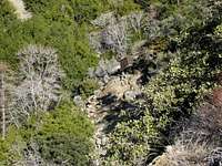
Allison Gulch is a stunningly beautiful narrow canyon cut by a tributary that feeds into the East Fork of the San Gabriel River. The canyon descends the southwest slope of Iron Mountain #1 (8,007') aka Big Iron. Moving down Allison Gulch Jan. 14, 2007
High in the canyon, at an elevation of 4,110 feet, stand the abundant remains of Allison Mine, a gold mine that operated between 1914 and 1942. No matter the route taken, the mind boggles at the determination required to haul heavy machinery for crushing the ore up near-vertical slopes and to get the tons of crushed ore back down the mountain. Hardy men were these!
 A structure juts out of the slope at the site of Allison Mine (4,110')
But Allison Gulch is not just about sight-seeing. To have an adventure, one can follow the canyon all the way to the bottom where Allison Creek empties into the East Fork river. To do this, you will need gear to do three or four rappels of gorgeous waterfalls, the longest rappel being 80-90 feet.
 One of the rappels in Allison Gulch 1/14/07
 Tom Becht rapping down icy waterfall face 1/14/07
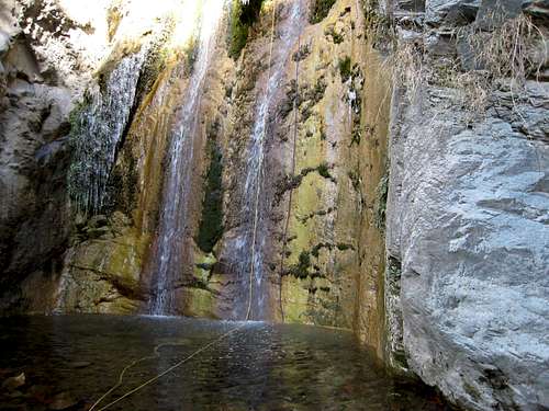 Our rappel ropes in the landing zone 1/14/07
In between rappels, you sometimes have to get creative in downclimbing a particular section as shown in the photo bottom right.
 Here I am downclimbing a tree angled across the icy creek below 1/14/07. Photo by T. Becht
Alternatively, one would likely find equal adventure going up the canyon from Allison Mine to attempt summiting Big Iron. From the mine, you would have 3,900 feet of gain to reach the top of Iron. The creator of this page has not attempted that route, but based on what one can see with the eye up canyon, it looks like there would be some sections of 3d class rock to negotiate on the ascent.
Getting There
From either Interstate 210 or Interstate 10, take the Azusa Avenue (SR 39) exit and go north winding up San Gabriel Canyon about 12 miles to where the East Fork Bridge intersects SR 39. Turn right and go across the bridge. In about 5 miles, you will come to a point where the road starts to curve very sharply right and uphill. Right at this curve, you will see a road straight ahead of you. Continue straight onto this road and in less than a mile you will come to the large paved parking lot at the end of the road overlooking the East Fork of the San Gabriel River. This is the East Fork/Heaton Flat trailhead. Park here.From the trailhead parking area, go past the large gate and hike north and east on the road that follows above the river bank for about ½ mile. There, by a smelly outhouse, the Heaton Flat Trail (designated 8W16) begins on your right. This is the first option for getting to Allison Mine. Hike up this trail for 3.3 miles to a saddle at 4,582' elevation. Just beyond the saddle, you will locate a faint use trail on your left. This use trail, very overgrown in parts, traverses the slope for 3 miles to reach Allison Mine.
Your second option, more of a navigational challenge than the first route above, is to continue past the Heaton Flat Trail junction and proceed up the East Fork of the river (lots of river crossing to be done here) a little over 2.5 miles to where Allison Gulch joins the river. You must be very careful to make sure you have the right canyon; the entrance to Allison Gulch is about 200 yards past a large cliff on the left side of the river known as Swan Rock. Navigating up Allison Gulch from this point can be tricky so consult a detailed route source (one source is Adventure Hikes and Canyoneering in the San Gabriels) before you attempt this route. When you reach the mine, you will be on the other side of the canyon from the arrival point of the first route above.
Red Tape
A permit is required to hike the Heaton Flat Trail. Permits are available at the San Gabriel River Ranger District, 110 N. Wabash, Glendora, telephone 626.335-1251, or from the United States Forest Service Entrance Station on SR 39.You will also need an Adventure Pass to park at this trailhead within the Angeles National Forest. They are sold at most sporting goods stores in Southern California ($5 per day or $30 for a yearly pass).
Camping
Heaton Campground is located at the bottom of Heaton Trail right above the East Fork of the San Gabriel River. It is free. Apart from that, although there are no developed campsites along the Heaton Flat Trail, there is apparently no prohibition against camping along this trail providing you have your permit and observe fire restrictions.If your destination is Allison mine and you want to make it an overnight, you can pick a camping spot at the mine on either side of the creek.
Other Information
USGS Topos Mt. San Antonio 7.5 Mt. Baldy 7.5 Crystal Lake 7.5External Links
Adventure Hikes and Canyoneering in the San GabrielsAngeles National Forest