
-
 10838 Hits
-
 82.19% Score
-
 15 Votes
|
|
Canyon |
|---|---|
|
|
Hiking |
|
|
Spring, Summer, Fall, Winter |
|
|
Overview: A Waterfall and a Gold Mine
This oak and sycamore studded canyon pokes into the San Gabriel front range foothills in a generally northeasterly direction. The canyon cuts its passage between Sunset Ridge and the hog-back 4,485 foot Brown Mountain to the northwest. Millard Canyon features a 50-foot waterfall at its lower end and the remains of a gold mine in its upper reaches.
One of the canyon’s most attractive features is its proximity to the urban world below. It would be hard to find another woodsy retreat that feels so remote yet is so close to a teeming metropolis.
Millard Falls is just ½ mile from Millard Campground.
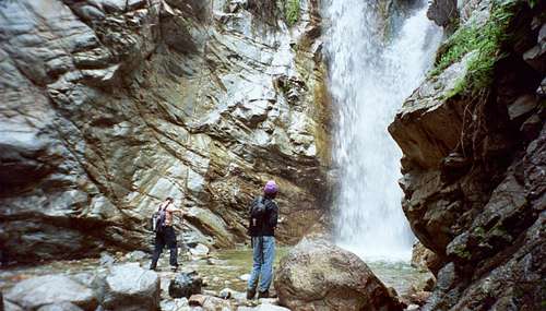
Millard Falls, March 23, 2006
The campground itself is just a stone’s throw from the Millard Canyon Trailhead parking area. If you follow the canyon upstream from the falls for about 1 ¾ miles, you will reach Dawn Mine, the site of what started out in 1895 as the most promising gold prospect in the front range.

Dawn Mine
Upstream of the mine, the Dawn Mine Trail leads in from the east. This trail ascends out of the canyon to the Sunset Ridge/Mt. Lowe Fire Road. When the mine was operating, burros were used to haul the ore up this trail to be shipped out on the Mt. Lowe Railway. The mine was worked into the 1950’s.
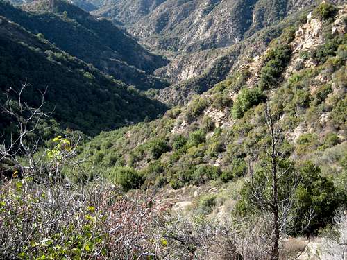
View down Millard Canyon from Cape of Good Hope
The canyon curves east beyond where the Dawn Mine Trail climbs out to the fire road. The canyon eventually abuts the same fire road again, this time at a point where the historic Mt. Lowe Railway rounded the head of the canyon near a site called the Cape of Good Hope.
Entry Points
There are two main entry points into the canyon. The first starts from the Millard Canyon Trailhead. Walk past the fire road gate the short distance to Millard Canyon Campground. At the upper end of the campground, the canyon creek runs across the fire road. Here, go right and you will be entering Millard Canyon following the creek upstream. The falls are ½ mile up the narrow gorge. In order to continue upstream past the falls, backtrack from the bottom of the falls for about 200 yards. Going now downstream, you will see on your left a faint and very steep use trail that will get you above the falls so that you can continue your journey up canyon.
Millard Creek at mouth of canyon, Jan. 1, 2006
A second entry point is from the Sunset Ridge Trailhead. Walk to and past the fire road gate onto the Sunset Ridge-Mt. Lowe Fire Road.

Start of Sunset Ridge Trail into Millard Canyon
Getting There
The two trailheads mentioned here are in the same area within a mile of each other.Millard Canyon Trailhead
From the 210 Freeway exit at Fair Oaks Ave. and take Fair Oaks north toward the mountains. At Loma Alta Drive, turn left and proceed about ½ mile to Chaney Trail Drive. The intersection is marked by a flashing yellow traffic signal. Turn right onto Chaney Trail Drive and ascend to Sunset ridge where you will come to a junction. To get to Millard Canyon Trailhead and campground, go left here and down the road about a mile to the trailhead parking lot.
From the parking lot, proceed through or around a white gate about 100 yards to the campground. At the upper end of the campground, you will come a creek crossing. Go right and you will be starting into Millard Canyon following the creek upstream.
Sunset Ridge Trailhead
Alternatively, when you get to the junction atop Sunset ridge mentioned above, look immediately to your right and you will see a white fire road gate and some very limited parking spaces along the road in front of the gate. This is the Sunset Ridge Trailhead. If there is no parking here, start back down Chaney Trail Drive and you will find plenty of parking along the road.
Walk to and past the fire road gate and you will be on the Sunset Ridge-Mt. Lowe Fire Road. About 400 yards up the fire road, you will come to the start of the Sunset Ridge Trail off to your left. This trail contours Sunset ridge above Millard Canyon. About ½ mile from the start of the trail, you will come to a junction. To your left is a bridge that crosses over to the creek (at this point you are above Millard Falls) that winds up the canyon.
Red Tape
You will need an Adventure Pass or Golden Eagle Pass to park your vehicle at either of the two trailheads. There have only been rare occasions when Adventure Passes ($5 per day or $30 for a yearly pass) were sold at these trailheads. It is best to purchase one beforehand. They are sold at most sporting goods stores in southern California.No permits are required to hike in this canyon.
Camping
Millard Canyon Campground is a developed public campground just two hundred yards from the Millard Canyon trailhead. The campground is just ½ mile southwest of Millard Falls.
Millard Creek running next to campground, 1/1/06
Other Information
USGS 7.5 Topo:PasadenaBeing a narrow canyon, you will want to avoid it during times of heavy rainfall when the creek becomes swollen. Because San Gabriel Mountain canyon creeks are a prime habitat for poison oak, consider wearing long pants and long sleeves to minimize your exposure to this plant’s rash-inducing oils.