
|
|
Canyon |
|---|---|
|
|
34.17765°N / 117.99069°W |
|
|
Hiking, Bouldering |
|
|
Spring, Summer, Fall, Winter |
|
|
Overview
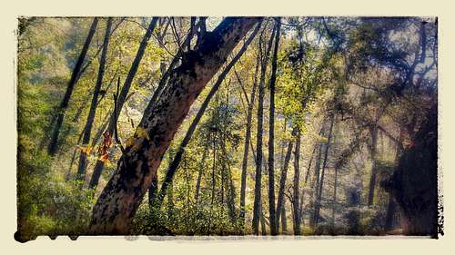
In the Forest
Getting There
DrivingFrom the 210 Freeway, take the Mountain Ave. exit in Duarte and head north on Mountain Ave. After 1.1 miles, turn left (west) onto Foothill Blvd. After 0.6 miles, turn right (north) onto Canyon Blvd, a street lined with old houses and giant old pines. You follow this about 0.7 until the last intersection before it dead ends, where a brown sign reads Monrovia Canyon Park ->. You turn right and follow the slightly windy road northeast another 0.7 miles or so until you see a narrow-angled fork in the road, with a sign in between again saying Canyon Park -> and Oakglade Dr. on the left. Park somewhere before reaching this fork (south of it): there will be signs saying "No parking 10 am to 2 pm Tuesday" on the east side of the street and "No parking 10 am to 2 pm Wednesday" on the west side of the street due to street sweeping.
If you drive to the entrance gate of Monrovia Canyon Park by following the signs you've gone too far. Well, that does depend on what you want--there are two parking lots further up the trail but if you park there you will have to pay $5 per vehicle (see Red Tape). Parking before the gate only adds a half-mile to a mile of a pleasant walk.
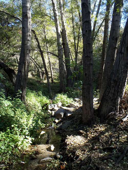
The tiny stream at the bottom of Monrovia Canyon.
After You Park
If you park at the lower lot before the gate you will follow the signs towards the gate (only if you want to; you could just sit there in your car) and walk along the road as it enters the canyon. After about 0.5 to 0.75 miles you will hit a little shack in the road: a fee station. Just ahead of this, a trail on the left side of the road begins and winds its way up the chaparral slopes. This is the Bill Cull trail, and the most difficult part of the hike, although it is really not too difficult, even for beginning hikers. There are a few other routes to the falls, which will be discussed further later on.
The Bill Cull trail wanders in the chaparral, passing a short marked trail that leads to an overlook. After about a mile, the trail drops down into the lush canyon, seemingly entering a completely different world as you cross the stream. Suddenly everything is green and the trees are towering. Shortly after crossing Monrovia Creek the first time, you reach a T fork, with the right leading you on the "nature trail" back to the road, and the left leading you towards the waterfall. Another fork not far ahead has a trail to the right leading to the "nature center" and ahead to the waterfall. More on the nature center and trail later. If you go left and then straight, towards the waterfall (signs are posted), you meander back and forth across the stream, slowly ascending the canyon as you feel to be in a pristine forest valley somewhere in England during the Middle Ages. About 0.5 to 0.75 miles after descending to the stream you reach the waterfall, which is more like a waterslide as the water cascades down the rock face.
After resting for a bit, choose your route back: either going back the way you came along the Bill Cull trail, following the Waterfall trail straight back to a parking lot and the road, which is still beautiful and shaded by immense trees, or hang a left after about 0.5 to 0.75 miles to ascend to then Nature Center, which at the very least has a good view of the Los Angeles valley and possibly ocean on a clear day. A road about 0.75 miles north of the entrance gate leads east to Sawpit Canyon, including Sawpit Dam and a myriad of other trails. In any case, any trip to Monrovia Canyon is bound to be a cool, relaxing adventure in one of the most lush spots in the San Gabriel Mountains.
![Monrovia Canyon Falls]()
Mini 30-foot waterfall cascading down diorite is the end point of your journey in Monrovia Canyon.Monrovia Canyon Park, run by the City of Monrovia's Community Service Department, has been in operation since June 1911. It covers about 80 acres and has about 70 parking spots (inside the official park). The park is open to vehicles every day except for Tuesday 8 AM to 5 PM on weekdays and 7 AM to 5 PM on weekends. However, note that the closed dates really only apply to vehicles--if you park outside the park and walk in, there should be no problem. It costs $5 to park inside the park, and your Angeles Adventure Pass will not work here--this is a separate, standard $5 fee.
Red Tape
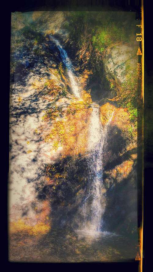
Mini 30-foot waterfall cascading down diorite is the end point of your journey in Monrovia Canyon.
There is a cabin/conference center that may be reserved for conferences or overnight stays, it has outdoor barbeques, a refrigerator, microwave and sink. There is a campsite as well next to the nature center that can be reserved, and it could be suitable for large groups, up to 70 (conference center is for 50 people maximum). The campground and cabin cost a little money, however, so if I were planning on camping, I would likely take a trail up Sawpit Canyon and camp somewhere outside of the park boundaries. Link for official webpages below.
Geology
The rocks in Monrovia Canyon are on the upper plate of the Vincent Thrust fault, meaning they are older (Precambrian to Cretaceous) than those of the lower plate to the north. Your walk from the car to the falls will mostly consist of walking through Cretaceous quartz diorite, while passing lines and blobs of Precambrian light and dark gneiss and pods and dikes of intruding Cretaceous leucocratic granites. Shortly after passing the fork of Sawpit and Monrovia Canyon, you pass the South Sawpit Fault, a normal fault with the footwall to the north. Soon after you encounter lanes and pods of gneiss and some granite between the diorite, and then in a narrow line of gneiss, the North Sawpit Fault, similar to the south, just a quarter mile or so short of the falls (which cascade down diorite).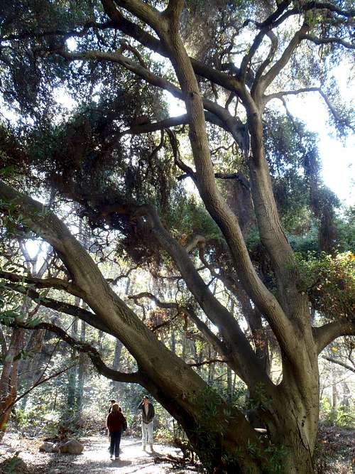
Once you descend to the streambed, the trees become enormous and mystical, draping and shading immense areas.
External Links
Unofficial, but most helpful, Monrovia Canyon Park website includes maps, videos and any information you could want about the park: http://hikertechnologies.com/mcp_trails.htmOfficial Monrovia Canyon Park webpage mostly just has info on how to rent and reserve the picnic areas and cabin: http://www.cityofmonrovia.org/recreation/page/canyon-park
Geologic map of the area (Monrovia Canyon is in about the south-central part of the image): http://ngmdb.usgs.gov/Prodesc/proddesc_71696.htm
Useful general info about the geology of the San Gabriel Mountains: http://geomaps.wr.usgs.gov/archive/socal/geology/transverse_ranges/san_gabriel_mtns/index.html
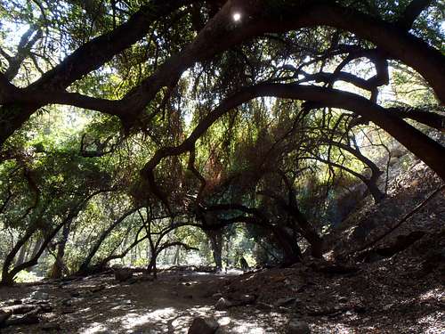
Archways of oaks adorn the trail.