
|
|
Area/Range |
|---|---|
|
|
20.715°S / 67.9175°W |
|
|
Hiking, Mountaineering |
|
|
Spring, Summer, Fall, Winter |
|
|
21463 ft / 6542 m |
|
|
Introduction


The Andes range is split on most of its length into two or three Cordilleras : Occidental, Central and Oriental.
For Ecuador, two SP pages describe the Occidental and Oriental Cordilleras. The purpose of this page is to cover the Occidental Cordillera that runs along the Chile / Bolivia border.
Up north it joins the Volcanoes of Arequipa (Peru). Down south it reaches the Puna de Atacama (Argentina / Chile).
Historically, this region was entirely part of Bolivia. However following the War of Pacific (1879 - 1883), Bolivia lost the territory between the Cordillera Occidental and the Pacific Ocean to Chile.
Nowadays the border runs through most of the important summits of the region.
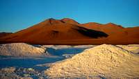
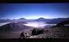
As far as landscapes are concerned, the Cordillera Occidental is essentially mineral with rich brown / red / orange colors. A few colorful lakes here and there give peace to this rough and moon-look-alike environment.
In the Northern part (Sajama region) due to higher rains falls in January and February the summits are covered with snow, giving wonderful views.
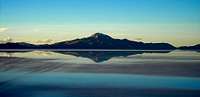
A few salt flats bring bright white contrast, among others the Salar de Atacama and of course the incredible Salar de Uyuni.
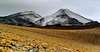
All of its summits are from volcanic origin and therefore represent easy non-technical ascent (apart from some routes on Sajama). Most of the time on rocks, sometimes on snow.
Sajama (Bolivia), Parinacota (Chile) and Licancabur (Chile) are probably the most climbed of all. But be sure that this area is far more quiet than Aconcagua (Argentina), Cordillera Blanca (Peru) or Cordillera Real (Bolivia).
NB : a special "thank you" to Peter (a.k.a Ski Mountaineer) for his useful comments and for adding pictures specifically for this page.
Geographic overview

The Cordillera Occidental stretches over 600 kms. There are volcanoes to ascend throughout the whole the length. I won't cover every single summit in this page, only the main ones.
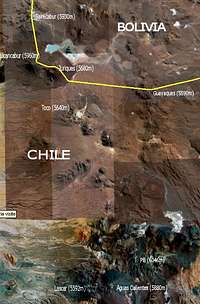
I have split this range into four main areas. It is quite complicated to move around in the region, as there no public transportation (apart from the Arica - La Paz road and the San Pedro - Calama road), and hardly any clear 4x4 trails to reach some of these summits. So I gathered in a table the summits close to a main access town : Arica/La Paz - Uyuni - Calama/Ollagüe - San Pedro de Atacama.
These mountains can be climbed all year long, most of them having very little snow even during the rainy season (December to March). Only Sajama, Parinacota and Pomerape should be prepared with more care, as they have a thicker snow layer, with crevasses and penitents.
Note that the Southern part described below as the "Licancabur group", could also be part of the Puna de Atacama.
But as it wasn't included in Corax's page, I've decided to mention it here. Corax's page concentrates on the area around Paso San Fransisco.
*click on the left map to see the whole*
Mountain groups within the Cordillera Occidental
1. Northern Part : Sajama group


To access this region, you can easily come from Arica (Chile, by the Pacific Ocean) or from La Paz with long-distance buses.
In all cases take a bus from a Chilean company rather a Bolivian one.
On that precise road I saw a crashed bus (Bolivian one) with a lot of harmed people.
If you plan to climb Sajama ask to be dropped off near Sajama village (Bolivia).
For Parinacota and Pomerape ask for Parinacota village (Chile).
The buses don't go throught these villages, you will have to hitch-hike or walk the last few kilometers.
Another option would be to book an agency or rent a 4x4 in Arica. Easier solution to reach Guallatire and Acotango for example.
| __Mountain__ | __Country__ | __Altitude__ | __Grade__ | ______Photo______ | |
| Sajama | Bolivia | 6542m | PD / AD |  |
|
| Parinacota | Chi / Bol | 6342m | F / PD | 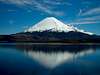 |
|
| Pomerape | Chi / Bol | 6282m | PD |  |
|
| Guallatire | Chile | 6063m | F |  |
|
| Acotango | Chi / Bol | 6052m | F | 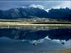 |
|
| Capurata | Chi / Bol | 5950m | n/k |  |
|
| Larancagua | Chile | 5715m | n/k | ||
| Umurata | Chi / Bol | 5700m | n/k | ||
| Patilla Pata | Bolivia | 5430m | n/k | ||
| Quisi Quisini | Bolivia | 5395m | n/k |
2. Central Part : Tunupa group

This part is especially known for its huge salt flat called Salar de Uyuni.
There are no public transportation to reach these Volcanoes.
You would have to book an agency from Uyuni (Bolivia) or Iquique (Chile) to drive you there, or rent a 4x4.
| __Mountain__ | __Country__ | __Altitude__ | __Grade__ | ______Photo______ |
| Sillajguai | Chi / Bol | 5970m | n/k | |
| Cibaray | Bolivia | 5869m | F |  |
| Isluga | Chile | 5501m | F | |
| Tata Sabaya | Bolivia | 5310m | n/k | |
| Tunupa | Bolivia | 5245m | F |  |
3. Central Part : Ollagüe group


As for the Tunupa region, the summits will require you to book an agency or rent a 4x4 to reach this area.
However from the big city of Calama (Chile), things are much easier than from Uyuni.
Especially if you intend to climb San Pedro or/and San Pablo.
Note that there is a weekly train that climbs from Calama to the village of Ollagüe, not really convenient to prepare an ascent !


4. Southern Part : Licancabur group


This part is as convenient for transport as the Northern part.
To reach San Pedro de Atacama (the main town, which is more like a village actually),
you can take an overnight bus (daily) from Santiago or Arica in Chile, and from Salta and Jujuy (Northwest Argentina) with a day bus.
For Licancabur, Juriques and Guayaques you can see with agencies going to Bolivia to visit the South Lipez Desert,
and asked to be dropped off at the border. For Lascar, Pili and Aguas Calientes, a 4x4 would be required.
| ___Mountain___ | __Country__ | __Altitude__ | __Grade__ | ______Photo______ |
| Pili | Chile | 6046m | F |  |
| Uturuncu | Bolivia | 6020m | F |  |
| Licancabur | Chi / Bol | 5960m | F | |
| Sairecabur | Chi / Bol | 5930m | F | 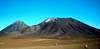 |
| Aguas Calientes | Chile | 5880m | n/k | 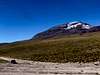 |
| Juriques | Chi / Bol | 5680m | F |  |
| Toco | Chile | 5640m | F | 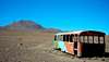 |
| Lascar | Chile | 5592m | F |  |
| Guayaques | Chi / Bol | 5590m | F |  |
NB : "n/k" means "not known"
Useful information
[img:338720:alignright:small:][img:338675:alignright:small:]
 Weather forecast :
For the Sajama and Tunupa groups, check : Meteo Chile - Region 1
For the Ollagüe and Licancabur groups, check : Meteo Chile - Region 2
Guidebooks :1. The Andes : A Guide For Climbers
John Biggar - Jul. 2005
ISBN : 0953608727
2. Bolivia : A Climbing Guide
Yossi Brain - Feb. 1999
ISBN : 089886495X
Transportation :1. Terrestrial
Buses in Chile are well organised and safe. Roads are in good condition.
One good recommendation (especially for the trip bewteen La Paz and Arica) is Pullman Bus.
In Bolivia roads and bus quality are far lower and might present a danger.
Avoid journeys at night time as they are many more chances to have an accident (poor visibilty and drunk drivers).
2. Air
To reach Arica and Calama by plane, you can fly with the national company : LAN.
Or use the low-cost Sky Airline. Both of excellent quality. Sky being cheaper.
Ski Mountaineer - Sep 21, 2007 11:10 am - Voted 10/10
War of the PacificCheck on the Chile-Bolivian war story. Did some Bolivians tell you that version? ASAIK Bolivia - backed my Peru - declared war on Chile back then (in a similar pattern Peru regularly threatens to do the same nowadays whenever a political problem in the country should be covered up) - with Chile doing a good deal of provocing it. But I am not well-informed about the Chilean-Bolivian war, however I did learn during my studies of the Chechen-Russian and Armenian(sorry, Karabakh)-Azeri war that the "truth" is never simple and rarely what the common opinion is. The Chilean-Bolivian conflict lasting on until today is a sensitive subject; accordingly - also since we have Chileans on SP - I would not take position (unless you are absolutely convinced) on one side.
Andino - Sep 21, 2007 5:05 pm - Hasn't voted
Re: War of the PacificI checked again my source (English guidebook by Footprint), and compared with a French book. It tends to make things unclear... to avoid any problems between communities here on SP, I took off the reason why the war started in the description. From what I understood by comparing, there was a border dispute between Chile and Bolivia, after the Spaniards withdrew. Chile invaded the Antofagasta region, which was part of Bolivia at the time, because they felt threatened. Peru supported Bolivia, therefore Chile carried on up North and invaded Southern Peru as well (and even managed to reach Lima). They gave back the Tacna region to Peru in 1929, but never gave back the Antofasta region to Bolivia... most likely because of the presence of mines. Chilean-British were already extracting minerals when this was Bolivia. But were even happier when it became Chilean. That's history. It is probably more complicated than what books say. I love Chile and the Chileans (I travelled for 50 days there), as much as I love Bolivia and the Bolivians (I travelled for a month there). People living today in these two countries are not responsible for what happened 120 years ago. And I'm no one to judge what opposes them. Peace & unity ! Thanks for your input and for giving me some perspective.
Baarb - Nov 1, 2011 10:12 am - Hasn't voted
AttachmentHi, was wondering if you would like to attach Cerro Acotango and Licancabur to this range. The page owners have left them in a state of isolation, without even coordinates. Acotango could be hyperlinked on the main page, as could Aucanquilcha, San Pedro, San Pablo, Sairecabur, and Juriques. Thanks.