
|
|
Mountain/Rock |
|---|---|
|
|
18.169°S / 69.147°W |
|
|
Mountaineering |
|
|
20807 ft / 6342 m |
|
|
Overview
The twins
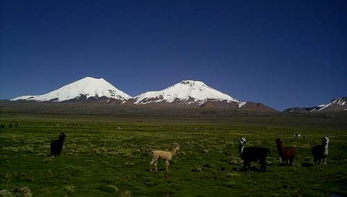
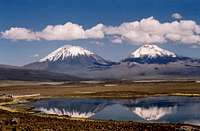
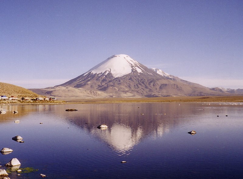
Cerros de Payachata, means twin mountains (Payachata=twin, in Aymara, the local indigenous language) and there are only two peaks in the range. It is usually counted as a sub-range in the Cordillera Occidental. Parinacota is slightly higher than its twin brother/sister Pomerape (6282m). Both volcanoes are right on the Chilean - Bolivian border and can be climbed from either side. Their closest neighbor is Bolivia's highest mountain Sajama (6542m) which isn't more than 20km away.
Parinacota is an active (fumeroles) stratovolcano and had its last real eruption about 1700 years ago. The crater is about 300m wide and 250m deep and young lava flows on the peak's western side is a proof of quite recent activity. Pomerape is considered to be dormant and an older mountain, so strictly speaking, these two peaks are only twins by appearance, not by birth.
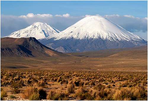
Los Payachatas (Pomerape & Parinacota)
Parinacota collapsed about 8000 years ago and produced a huge debris avalanche that traveled 22 km in a westerly direction. This debris blocked drainages and formed Lake Chungará, the area's largest lake.
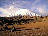
Because of its almost perfect symmetry and good-looking snow cap, the peak has become a favorite for tourists, photographers and of course climbers. The normal route is a walk on scree and later ice/snow and as the inclination seldom becomes steeper than 40 degrees, basically any fit person can make a try to summit this extraordinary beautiful mountain.
Parinacota was first climbed in 1928 by Joseph Prem and Carlos Terán.
Getting There
Twin volcanoes
Parinacota is located in the extreme NE of Chile, where the country borders to Bolivia. The closest really large city is La Paz, the capital of Bolivia, which is about 300km and five hours away. Arica, in Chile is at the Pacific coast and is about 180km far (and almost 5000 vertical meters!).
- From Chile
The logical starting point is Arica, from where you can catch good quality, fast buses to Putre. The ride is a constant climb and even if it's 120km it takes over three hours. If you stay the night in Putre, you can acclimatize with climbing Nevado de Taapaca, an easy climb to 5800m.) From Putre there are local transport to the border and further to Lagunas and Sajama villages on the Bolivian side.
From Sajama Village there's a track leading to the foot of the peak.
You can also jump the bus/hitch at Parinacota village (very small) and walk in from there. There is a refugio on the southern side of Lago Chungara, which can serve as a base for the night as well. The Lauco National Park ranger station is also located here and the rangers are the ones to ask about the best route to the mountain's foot.
Walk in from all the mentioned places is ranging from 10-15km. There are plenty of tracks from the ranger station, but just walk towards the peak along the one that looks most well-travelled.
- From Bolivia
From La Paz you can reach Village Lagunas or Sajama in 5 - 5½ h. Buses leave from the main long-distance bus station and the ones you want to catch is either those headed for Putre/Arica or Oruro. If you choose the latter alternative, you have to change bus on the way. The place is a small transport hub, which I have forgotten the name of, but it is located about a 100km out of La Paz.
Watch out for pick-pockets on the main bus station in La Paz!Red Tape
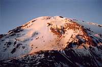
From Bolivia![parinacota seen from the...]()
Parinacota seen from SE
There's no peak fee, but you have to pay an entrance fee of about $US 2,5 when you enter Sajama National Park. Officially you also have to register at the ranger station in Sajama village. This includes filling up a form about when you reckon to be back. This is for your own safety and if you fail to report within the time you tell the rangers, I guess they'll come looking for you.
If you intend to climb in the off-season, i.e. between November and March, you have to sign a disclaimer that you're responsible for all your actions and that you have been informed about the increased danger of climbing in the off season. - From Chile
You need a "border zone permit". No one will probably check this, but that's the official deal. The authority in Chile which handle these issues is DIFROL. Personally, I have bad experiences with these guys. Never recieved any of the border permits I wanted. Never got any answers whatsoever. The border permits are free of charge. There is no peak fee.
When To Climb
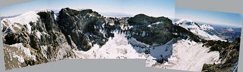
Panoramic view from south summit
The main climbing season is from late June to mid September. This is the winter season of the southern hemisphere. It's also the time with the lowest precipitation and most stable weather. Between May and September there's almost no risk of any rain or snow at all.
A simple info page with all the basics.
For a more details and forecasts look at Meteoexploration's info for Parinacota.
Mountain Conditions
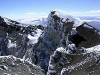
Pomerape seen from high on Parincota
It's a high probability you'll pass the border posts between Bolivia and Chile one or two days before your intended climb of Parinacota. The border police usually have good info about the weather and if they don't, ask them to call HQ for a fresh forecast.
On both sides there are National Parks and the rangers will help you out with weather forecasts.
Technically speaking, Parinacota is a very straightforward climb, but be sure to bring an axe and crampons as there can be some icy parts.
Camping
Camping is allowed everywhere, but pay really good attention to your tent. Thefts have been reported. One person lost the tent and everything in it and she was only away from the camp spot for about three hours.
When climbing in Peru, Ecuador and Bolivia I usually break camp, hide the folded tent and all the gear I don't need on the climb.
Maps
- World Cart/RV Verlag's Südamerika, Süd. ISBN 3575332827. A good overview map of this part of South America
- Detailed topographic map: TPC (Tactical Pilotage Chart) P-26A, 1:500 000
- Arica, 1:500 000 from IGM
- Interactive map

Routes Overview
The true summit seen from a false summit
- From Chile
You start as low as 4500 meters and to make the 1850 meter ascent in one day takes very good acclimatization. Most climbers break the climb at 5100-5150m where ok camp-spots can be found. The path is well marked with small cairns of rocks. Aim for the long ridge in the east. When reaching it, it's basically only one way to go - on the ridge, all the way to the crater rim. - From Bolivia
If anyone have climbed the peak from Bolivia, please add the info here, or even better: make a route page!
Commercial Expeditions
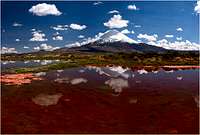
Parinacota seen from Laguna Chungará.
- Sky Sorata
- Bolivian Mountains Tours & Travel
Info submitted by gnome (in the summitlog). I think this is important info and therefore it has its place here.
"Went there with PO and Eric, also from France. We took a guide at Putre (the owner of agency Aymaruta in Putre) and went at a BC at approx. 5000m. to spend the night. Next morning, we began to climb at 4 O'clock. We had 2 hours of climb on big rocks, sometimes a bit steep, before arriving at snow (at around 5700m). The snow was very icy and with little grietas everywhere. As the slope was becoming quite steep for these snow conditions, I told the guide that we should use a rope... He went a bit embarassed to tell us that he had forgot the rope at BC... I decided to go back.
I am returning there in October 2005 on the bolivian side.
My message is clear: unless they changed radicaly, don't attempt Parinacota with this company (Aymaruta)! They were expensive, they provided poor equipment, they had very poor skills in mountainering and no experience of guiding people."
Football In The Neighborhood!
Parinacota and Pomerape is not as often climbed as the higher neighbor Sajama. A happening worth mentioning, (even if it didn't take place on Parinacota) is the football match on top of Sajama.
- The full story, with lots of cool photos!
- UIAA news about the match
External Links
Global Volcanism Program - Parinacota
Skimountaineer as usual give you some good information
One commercial organizer
Weather forecast for Parinacota