
|
|
Mountain/Rock |
|---|---|
|
|
43.83270°N / 114.5181°W |
|
|
10981 ft / 3347 m |
|
|
Overview
Geographical Breakdown: Rocky Mountains>Bitteroot Chain>Sawtooth Range>Boulder Mountains>
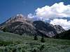
State Highway 75 between Sun Valley and Stanley, Idaho may be one of the most beautiful stretches of road in the United States. About 12 miles north of Ketchum the Big Wood River Valley opens into wide valley below the impressive Boulder Front.
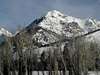
It is here that the Boulder Mountains rise precipitously 5,000' from the valley floor. Boulder Peak is the first of the impressive mountains one sees driving north along Highway 75.

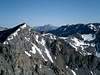
Boulder Peak's impressive east face leaves an impression in people's minds as they drive along, but even more so of an impression on those who climb it. Its ridge that extends eastward also include many, impassable, Sawtooth-like, cirques and spires, one of which has been officially named by the USGS Crown Point.
This mountain is a destination for many local scramblers as it harbors two, exciting routes. People also come to see the remains of Boulder City ghost town, which was once Idaho highest settlement sitting at more than 10,000'. Harsh winter conditions have taken a toll on the old town but amazingly, some buildings still stand.
Due to the technical climb required for an ascent of Boulder Peak, it is not climbed often, even by those who venture into the ghost town. The easiest route is the South Ridge, which requires a good stretch of class three scrambling.
 |  |  |  |  |
Getting There
Air Access
Access to Ketchum and Sun Valleyby air is from the Friendman Memorial Airport in Hailey, Idaho in the southern end of the Big Wood River Valley.
From the airport,
Seasonal Non-Stop Flights To
- Oakland
- Los Angeles
Year Round Non-Stop Flights To
- Seattle
- Salt Lake City
Airlines
- Horizon Air
Drive north from Ketchum, Idaho for 13 miles until reaching the Boulder Creek road on your right, at the top of Phantom Hill.
The Boulder Creek Road is one of the roughest in the state and requires excellent four-wheel driving skills.
After a short distance, a major fork in the road greets you. Left will take you toward the unnamed drainage west of Boulder Peak, and right will take you up Boulder Creek toward Boulder City.
Take the right fork to access the
Take the left fork to access the
Red Tape
No permits are required. No fees are needed. Boulder Basin Road closes with the first snow fall and opens when conditions permit in the spring. This is an area with high mountain goat population, please stay a good distance from them and let them be.
When To Climb
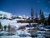
Even though the south ridge recieves a good deal of sunlight, it is not usually snow free until mid-july. For the north couloir it is a hot spot for summer back country skiiers with snow often remaining well into july. Snow often settles into these mountains in early october.
 |  |  |  |
Camping
There is plenty of camping around the turnoff for Boulder Basin Road. While many people turn this hike into a two day hike by setting up camp in the beautiful Boulder Basin.