
|
|
Mountain/Rock |
|---|---|
|
|
46.36274°N / 14.55804°E |
|
|
Hiking, Mountaineering, Trad Climbing, Mixed, Scrambling, Skiing |
|
|
Spring, Summer, Fall, Winter |
|
|
8307 ft / 2532 m |
|
|
Overview
 North side
 South face
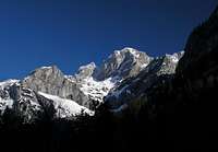 South
South South East
The central position, the pyramidal SW aspect, the elegant ridges, the severe N wall with still a bit of a glacier - all this contributes to the fame and magic of Skuta (2532m), one of the three 2500ers in the range.
Skuta has two sides, the N side above the Ledine glacial terrace, and the S side above the Kamniška Bistrica valley.
The N and NE faces reach the Ledine plateau with a 500m drop above a disappearing glacier.
The south side of Skuta is divided in two parts: to the east, the karstic grounds Mali Podi below the Skuta SE wall, and to the west the karstic grounds Veliki Podi below the Skuta S wall. What separates these grounds is a prominent ridge leaving the summit southeastwards, elegantly twisting until it finally drops to Konec (Kamniška Bistrica).
The ridge which leaves the summit westwards becomes Štruca (the loaf) and further Dolgi hrbet (the long back).
The E ridge (the famous Rinka-Skuta Ridge) very slenderly reaches Kranjska Rinka.
Getting There
A bird flies ten miles from JP to Skuta.The vicinity of an airport is of course an advantage (also when mountain rescue is involved).
Logistics:
Youth hostels, campings, public transports (including airports), gear stores and so on are available in Ljubljana (Slovenia) and in Klagenfurt (Austria).
Trailheads:
Kokra
Kamniška Bistrica trailhead (and hut)
Jezersko
Vellach trailhead see this page for info regarding the Vellach trailhead.
Logarska dolina
Huts:
Cojzova Hut
Češka Hut
Kamnik saddle Hut
Okrešelj hut
Bivouac Kemperl
Bivouac Mali podi
Kranjska koča.
Maps:
Grintovci 1:25000
Kamnik-Savinja Alps 1:50000
1/50000 Steiner Alpen
Steiner Alpen 1:50000
Red Tape
Unless expressly signalized (barrier, signpost), and upon your own responsibility, macadamized roads are allowed and visible on maps (these roads are mainly maintained for lumbering and hut cargo cable-way station access purposes).Fishing and hunting are regulated.
Wild camping and open fires are not allowed.
The Kamnik-Savinja Alps are part of the Natura 2000 program.
The Logar valley (Logarska dolina) is a Landscape Parc and there is a fee for the road along the upper part of the valley, in the summer months during the daytime.
Camping
LjubljanaKamnik
Tržič
Voelkermarkt
Luče
Bor - Mar 14, 2011 3:45 am - Hasn't voted
Re: UpdatesI gave you the rights for editing.