
|
|
Mountain/Rock |
|---|---|
|
|
45.17610°N / 116.1188°W |
|
|
Hiking, Scrambling |
|
|
Summer, Fall |
|
|
8767 ft / 2672 m |
|
|
Overview
 The north (left) and south summits of Bruin Mountain from the Hazard Creek meadows
There may be some confusion as to which peak is Bruin Mountain as different maps give different peaks the name. USGS quad maps list the northern peak, which is the higher of the two at 8,767 feet as Bruin Mountain, but the Payette National Forest map gives the name to the southern peak, which is 8,607 feet. Also the southern peak has an official brass cap on the summit that labels it as Bruin Mountain. The quickest routes to the peaks are separate, but the summits can be climbed together if desired. The connecting ridge is generally an easy traverse, but the north slopes from the southern peak onto the ridge can be tricky or dangerous in places and there are some difficult rocks between the peaks to negotiate. The northern peak has prominence of 1,627 feet, while the southern peak has 387 feet of prominence and is one mile away. For our purposes, they are here referred to as Bruin Mountain, north and Bruin Mountain, south. This page is for Bruin Mountain, north.
Bruin Mountain north is the second highest point in the Grassy Mountain sub-range of the extensive Salmon River Mountains.
 The north side of Bruin Mountain, north
The north summit is formed by an elongate pyramid with steep east and west slopes and a spectacular north cirque face. The razor summit ridge is formed by large granite blocks that are difficult to negotiate, but stepping around them; generally on the west side is not too difficult. The east side is steeper, but a couple difficult passes through the vertical rocks can provide challenging scramble routes. Even the precipitous north face has class 3 and 4 routes through the extensive cliffs that can be scrambled hand over hand.
 |
 |
 |
 |
The view from the summit takes in the Long Valley below McCall to the south, endless Salmon River Mountains to the east and the Hazard Lakes to the north. In the distance down the long U-shaped glacial valleys, the Salmon River Canyon and the Slate and Gospel Hump Mountains beyond are seen. The furthest view is probably to the west where the Seven Devils, Wallowa Mountains and even the more distant Elkhorn Mountains can be seen if the air is clear and you know just where to look. Much of the surrounding spruce and subalpine fir forest was destroyed during the severe 1994 fire season when approximately 400,000 acres burned here. The skeletal forests cover nearly the entire landscape, but small pockets of unburned forest are present in some of the moist valleys and in isolated protected positions on the higher summits where the lighter fuels wouldn’t carry the fire.
Getting There
 Hazard Creek Meadows
 North ridge
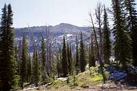 Summit from west ridge
 West slope of summit
 View north from west ridge
 North ridge, easy part
Turn north onto the Brundage Mountain Ski Area road (Forest Service Road 257) off of Highway 55. This road is also signed as the Goose Lake Road. Coming from the north, this is a left turn 0.4 miles south of mile marker 150 and about 6 miles east of New Meadows. From the south this is a right turn 0.6 mile past mile marker 149 or right about 4 miles west of McCall. Go 21 miles from highway 55 to the upper Hazard Lake trailhead at the Hazard Lake Campground. The road can be extremely bumpy in places.
The parking area is small with space for only a few cars, but it generally is not heavily used. The trail passes by the south end of Hazard Lake Campground, and then ascends the valley bottom to the south for about 2 miles to Upper Hazard Lake where the scramble begins. Follow the ridge above the north margin of the lake to the crest then turn east. Continue on the ridge and up the summit cone. The large talus slope that dominates the center of the west aspect provides easy stepping almost to the top.
The north ridge is also a nice hike from the 308 road east of Hazard Lake. This starts out as an easy hike, but gets interesting about two miles in. Generally stay on the east side when things get difficult, but after a slight jog to the southwest, the ridge straightens to the south. Here find your way through difficult rocks to the west side. Don’t get on the west side too early because it’s completely impassible. Once safely onto the west side, continue south at the foot of the crest rocks. Continue to the summit block and scramble the northwest ridge of pyramid. Use a good topo map and caution on this route.
Red Tape
None.Camping
 Upper Hazard Lake from summit
The nearest developed campground is the Hazard Lake Campground on road 257. This campground is handy for Bruin Mountain north since that is where the trailhead is. Hazard Lake Campground is approximately 21 miles north from Highway 55. There is also good camping at Goose Lake Campground at the south end of Goose Lake or the excellent dispersed campgrounds found along the east shore of the lake. Goose Lake is about 10 miles north of Highway 55. There is also some dispersed camping to be had along Brundage Reservoir as well. For backpackers there are camping opportunities at Upper Hazard Lake, Hard Lake, Hidden Lake or any number of miscellaneous meadows or other suitable areas around the peaks.
When To Climb
June until the late fall snows get deep (Oct. or Nov). The road is not maintained beyond the ski resort in the winter, thus getting to this area would require snowmobiles.Mountain Conditions and Additional Information
 From Hazard Meadows
Current conditions and access information can be obtained from the New Meadows Ranger District office of the Payette National Forest.
New Meadows District Ranger Office
PO Box J
3674 Highway 95
New Meadows, Idaho 83654
(208) 347-0300
NOAA Forecast