
|
|
Area/Range |
|---|---|
|
|
45.31770°N / 116.208°W |
|
|
Summer, Fall |
|
|
8841 ft / 2695 m |
|
|
Overview
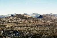
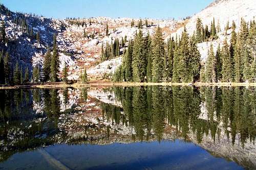
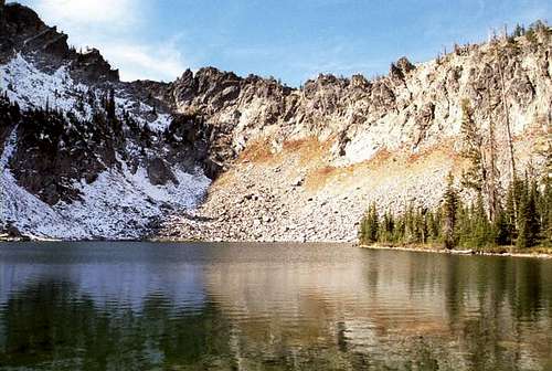
 Looking west across Upper Hazard Lake and Hard Creek Lake to the the namesake of the Grassy Mountains
Introduction
The Grassy Mountains are the westernmost sub-range of the vast Salmon River Mountains of central Idaho. They are named for a small group of lower summits collectively known as Grass Mountain from the west boundary of the sub-range. The elevations do not reach as high as other sub-ranges of the Salmon Mountains, but the bases of some of these peaks are much lower making for similar vertical rises. Patrick Butte, the highest of the group rises over 7,000 feet above the lower Salmon River Canyon near Riggins. Other peaks along the northern portion of the mountains are nearly as high above the river.The western boundary is formed by the Little Salmon River canyon, which separates these mountains from the Seven Devils Mountains. The eastern boundary is French Creek, however the Bear Pete Mountain/ridge group of summits is included as the eastern boundary because its too small to be its own sub-range and is closer and more continuous with the Grassy Mountains than others. The southern border of is harder to define, but is separated from the Lick Creek Mountains by the upper Payette drainage and from the West Mountains and Long Valley. In general the ridges and long glacial valleys are orientated in a north/south alignment and provide the separation between the Salmon and Payette basins.
The area is not designated wilderness, though it has that feel once away from the access roads. Much of it is managed for primitive recreation, though some areas allow motorized use and livestock grazing. See the Access section or contact the local Forest Service offices (see additional information) for more information on this if interested.
Refer to individual mountain pages for more detailed information for the mountain or area you wish to visit.
Peak List
 Patrick Butte Patrick Butte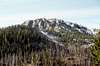 Bear Pete Mountain Bear Pete Mountain Bruin Mountain south Bruin Mountain south Granite Mountain Granite Mountain Grass Mountain pt. 8,180 Grass Mountain pt. 8,180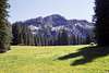 Grass Mountain pt. 8,156 Grass Mountain pt. 8,156 |
|
 Bruin Mountain north Bruin Mountain north Hard Butte Hard Butte Peak 8,500 (Black Tip Mt.) Peak 8,500 (Black Tip Mt.)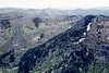 Peak 8,420 (MacHan Lake) Peak 8,420 (MacHan Lake) Sams Throne/ Lava Butte Sams Throne/ Lava Butte Slab Butte Slab Butte |
The Big Fires

Early explorers and settlers mention that forest fires were commonplace being commonly caused by lightning. After huge fire in 1910, the Forest Service made quick suppression every fire that started a general policy. This generally effective activity resulted the dead wood and undergrowth that normally burn up in a natural fire regime was accumulating setting the stage for much larger and hotter fires than would naturally occur. Eventually this has led to changes in management philosophy and now fire is allowed to play a more natural role in appropriate locations and ecosystems. However, the price of decades of unnatural fuel build up is still being paid.
Big fires have burned up much of the forest in recent years, especially 1994 when nearly 400,000 acres burned, primarily in the Grassy Mountains. This was one of the largest forest fires in the recorded history of the United States and left these mountains covered with dead skeletal forests. In 2007 a complex of fires mostly to east of the Grassy Mountains burned another 300,000 acres. Other large fires have occurred and often result in area closures that could impact trip plans. Call ahead and have alternative plans just in case as these closures have been common in late summer and fall of recent years. During the burning season air quality often poor and views greatly diminished. Today only fires that pose a threat to human safety or property or are unnatural in origin are suppressed, but most others are to a large degree allowed to burn or managed for resource benefit. Prescribed fires are often implemented for these purposes.
The Canyons and Rivers
 Little Salmon Canyon
The canyons of the main Salmon River and Little Salmon River are destinations for other outdoor activities. These rivers support runs of steelhead and salmon that provide excellent fishing experience and cultural importance to Native Americans. The Little Salmon is far less wild with Highway 95 and several small towns along its course, but it too is an important fishery. It is not used as much as a whitewater destination due to its low volume and long stretches of nearly continuous rapids. Occasionally expert kayakers can be seen. The Little Salmon also has an extensive waterfall area just after it drops out of the gentle meadows south of New Meadows and plunges into the steep river canyon. Several of these falls can be easily accessed from Highway 95 and keep an eye on the side slopes for several small, but exciting tributary falls.
Hot Springs
 Burgdorf is in the clearing at left-center.
Much of central Idaho is blessed to be studded with numerous hot springs. Nothing feels better after a hard hike or climb than a good soak in a hot springs. The following are in or adjacent to the Grassy Mountains and can be easily incorporated into an excursion into these mountains.
Burgdorf Hot Springs
This hot springs is developed, though it’s very rustic. It is found to the east of Bear Pete Mountain. There are cabins to stay in and campgrounds in the area. Refer to the Camping Section of this page for more information on this hot springs.
Zims Hot Spring
This hot springs is also developed and is located a few miles north of New Meadows, just off Highway 95 in the broad valley that separates the Grassy Mountains from the foothills of the Seven Devils Mountains. It is well signed on the highway and on cold days the billowing steam cloud is visible for miles around. A regular swimming pool and hot pools are provided. The water is exceptionally clean and hotter than most. There is a small restaurant that supposedly has good food.
Secech Hot Springs
Though this spring is not in the Grassy Mountains, it is just to the southwest near Chinook Campground. To reach it, hike south along the Secesh River from the campground for a few miles then ford the river and bushwhack up the steep slopes. The hot springs is undeveloped and consists of pools dug out and lined with tarps. Specific details to reach this spring are not provided here but can be found in any hot spring book that covers the region or with a search on the internet.
Two other undeveloped hot springs are along Highway 95 in the Little Salmon Canyon, but these are small and are on private property.
Research Natural Areas
The Forest Service designates and manages RNAs that are permanently protected and maintained in natural conditions, for the purposes of conserving biological diversity, conducting non-manipulative research and monitoring, and fostering education. Included in this network are high quality examples of widespread ecosystems, unique ecosystems or ecological features and rare or sensitive species of plants and animals and their habitat. These RNAs help protect biological diversity at the genetic, species, ecosystem and landscape scales. RNAs in common landscapes are representative of ecosystems in natural condition and serve as baseline or reference areas to improve practices on similar managed areas.
 Bruin Mountain RNA
Bruin Mountain
The Bruin Mountain RNA was created in 1989 and is 680 acres in size with an elevation range from 6,350 to 8,690 feet. It is located at the head of Little French Creek. The area is very rugged and rocky being shaped by alpine glaciation, which has left an expanse of raw granitic rock. It contains a small hanging valley that was created by a glacier on the north foot of the south peak of Bruin Mountain. The area contains mature subalpine fir and Englemann spruce forests representing at least seven high elevation forest habitat types. Part of the area is shaded most of the year and snow lies deep almost the entire year on the sheltered slopes. These areas support near true alpine plant communities, which typically do not occur at these elevations. The upper slopes are covered with stunted whitebark pine and extensive granite boulders. Avalanche paths filled with dense brush are common. Rare insects and plants have been found here. Much of the area burned in the mid-1990s.
Lava Butte
The 370 acres Lava Butte RNA was created in 1996 and ranges from 7,420 to 8,328 feet in elevation. The Lava Butte RNA encompasses a subalpine glacial basin/ridgeline system. In extensive wet sedge meadow vegetation water sedge is abundant, with scattered patches of bluejoint reedgrass and willows. A series of small, raised ponds occur in the wetland near the northern headwall. Lava Butte Lakes occur in the southern basins. The area offers an exceptional opportunity to study the influence of parent material on plant distribution as the contact between granite and basalt formations occurs on Lava Butte. Subalpine fir and whitebark pine habitat types and dry grass meadow vegetation occur in upslope positions.
Patrick Butte
The proposed 805 acre Patrick Butte RNA covers a significant elevation range from 5,490 to 8,841 feet on the highest mountain in the Grassy Mountains. This RNA contains a high granitic peak and three glacial cirque basins and two hanging valleys. Goat Lake, a three-acre lake that supports brook trout, lies in the northwest-facing cirque basin southwest of Patrick Butte. The area is primarily forested by whitebark pine and subalpine fir, which form an extensive pygmy forest on the upper slopes. The area also features low to high gradient streams, a small pond, several wet meadows, and exposures of granitic bedrock, boulders, and talus slopes. The research natural area provide representation of a temperature/moisture environmental gradient ranging from relatively cool, dry west-facing slopes dominated by whitebark pine woodland to cold, moist north-facing glacial cirques occupied by palustrine wetland vegetation and subalpine fir forest. The distribution of plant associations within the site may be differentiated on the basis of slope aspect, position, and configuration, and snow distribution. Large, old growth whitebark pine stands are present on all aspects on rocky scree slopes.
Access
The main access roads into the Grassy Mountains are the Warren Wagon Road, Goose Lake Road both of which enter the mountains on the south side. Following is a listing of the main trailheads accessed from each. This is just a general overview. For more detailed information refer to the individual mountain pages and local maps for areas you wish to reach.Warren Wagon Road
 Payette Lake along the wagon road
French Creek Trail 116
A small road to the left off the Wagon Road about 21 miles north of McCall provides access to Trail 116, which accesses remote canyon of French Creek.
Josephine Lake Trail 296
Take the Warren Wagon Road north from McCall to about three miles beyond Secesh Summit. Then turn left at the road marked Josephine Lake. The road is a very rough three miles to the trailhead for ordinary passenger cars. The trail is a steep one-half mile hike to a small 13 acre lake tucked into a granite cirque.
Burgdorf Area Trails
From the vicinity of Burgdorf, Trail 143 up Nethker Creek and Trial 144 up Pete Creek provide access to Bear Pete Mountains and the remote northeast section of the Grassy Mountains. Refer to the Bear Pete Mountain page for specifics on these trails.
Goose Lake Road
 Goose Lake Reservoir.
Granite Mountain Trail 165
This trail is reached by taking the short road to the west about half a mile north of Goose Lake. Its three miles to the summit of Granite Mountain and about one mile in another trail splits off to Twin Lakes, which is actually a two-lobed reservoir. Lots of cows are in this area.
Grass Mountain Lakes/Hard Creek
This trailhead provides access to the Grass Mountain Lake Trail 163 to the west and the Hard Lake, Upper Hazard area to the east via Trail 169. This trailhead is reached approximately seven miles north of Goose Lake (20 miles from the junction with Highway 55). The Grass Mountain Lakes are an easy two mile hike in and at least five other subalpine lakes are found in the area. Trail 169 to the east passes Hard Lake then descends to Upper Hazard Lake. This area provides access to Bruin Mountain or the other Hazard Lakes.
The Hazard Lakes
The main trailhead to reach the mountains is at Hazard Lake Campground, which provides access Upper Hazard Lake and Bruin Mountain. The two mile long trail to Upper Hazard Lake passes through several flower filled meadows before reaching the lake. Twenty seven miles up the Goose Lake/Hazard Lake Road is the half mile long trail to Big Hazard Lake, which is the largest of the three Hazard Lakes.
Clayburn Trailhead
This trailhead provides access to the northern and northwest portion of the Grassy Mountains. Use it to access Hard Butte, Patrick Butte and several lakes and remote canyons the drain north into the Salmon River. It is reached by taking the Goose Lake/Hazard Lake road north for 27 miles from Highway 55. A sign will direct you the last couple miles onto a different road, but this will appear to be the main road.
Lava Ridge Trails
Beyond the Hazard Lakes the road climbs, then crosses Lava Ridge before proceeding north into the lower Little French Creek basin. There are at least four trailheads along a few mile of road that provide access to Lava Butte, Lava Butte Lakes, points on Lava Ridge, Elkhorn Canyon and Little French Creek.
Other Access Points
 Fischer Saddle
Fisher Saddle provides access to Little French Creek Canyon, the Little French/French divide and Bruin Mountain. It is reached by taking the Goose Lake road then turning east onto the Brundage Reservoir road after about seven miles. Proceed for about three more miles then turn left and drive about six miles to the Saddle. Refer to the South Bruin Mountain page for details.
Access routes to the Grassy Mountains from the north or west are few and generally unreliable. While maps show several trails, most pass through private land where public access is increasingly blocked. Recreation and trails employees on the Payette National Forest have reported that historic access to the Elk Lake area from the west and Patrick Butte area from the north is now denied. They are working on these issues, but the landowners are not being very cooperative. Trail 373, which accesses the north part of the range from the Salmon River via Partridge Creek is reported open, but this requires a lot of hiking is less interesting, low country to reach the mountains proper. If entry from the west or north is desired the best thing to do is locate the potential route on the map and contact the appropriate people at the Forest Service offices listed in the Additional Information section for the latest information. The French Creek road from the Salmon River to Burgdorf is always open, but this is very rough in places and provides access for only a small less interesting section of the mountains in the northeast corner.
Geology
 Slab Butte
 Bruin Mountain south
The geologic story of the Grassy Mountains is relatively simple compared to other areas in the northwest. Approximately 120 million years ago, subduction related to accretion of the Wallowa/Seven Devils caused the formation plutons making up the Idaho batholith, which is the largest granitic body in the United States. The Grassy Mountains are nearly entirely granite as a result. The heating of the subduction caused metamorphosis of the rock in many areas has contributed to the formation of many valuable mineral deposits. These include gold, silver, mercury, antimony, tungsten, quartz crystal, and various rare-earth minerals. The volcanic Columbia River Basalts then flowed across much of the Grassy Mountains about 17 million years ago leaving some ridges and summits capped with a dark layer of basalt. It is here that the easternmost limit of the basalt flows can be found. Good places to see this rock in the Grassy Mountains is Lava Ridge and on some ridges in the extreme northwest corner of the mountains. These deposits are some of the highest elevation occurrences of this rock type.
The finale chapter to the geologic story is the alpine glaciation of the Pleistocene. During this time, various portions of the area were modified by advancing and receding glaciers, which formed the three Payette Lakes and the many of the nearby alpine lakes found nestled high in the cirques basins. Most of these formations are on the north facing slopes where snow deposition would have been heaviest. Glacially carved U-shaped valleys are also common with perhaps the French Creek basin providing the best example.
History
 Hard Butte Lookout
 Bear Pete cabin
 Bear Pete Lookout
The first people known to be present in these mountains were bands of the Nez Perce and Shoshone Indians. The Nez Perce and Flathead would meet in the meadows of Chamberlain Basin, which is east of the Grassy Mountains to trade. The Nez Perce likely passed through these mountains for these meetings as they did to their fishing camps on the South Fork Salmon River, which they did as late as 1917 according to historic records at the Payette National Forest.
The Northern Shoshone, also known as the Weiser Shoshone or Sheepeaters probably used the area more as mountain streams of the Payette basin in the vicinity of Payette Lake were where they gathered food, fished, and hunted deer. The story of these latter people is significant because they were able to live free in the Idaho Territory long after most other Indian Bands were forced onto reservations. They were also one of the only bands able to avoid conflict with the United States military during General George Crook's Snake War campaigns, and to avoid capture during Idaho's last Indian war, the 1879 Sheepeater Campaign. In 1896 they left the region and crossed the extensive Salmon River Mountains to live near relatives at Fort Lemhi and eventually Fort Hall where most of the descendants live today.
It is not known when the first white men entered the area, but they may have been Hudson Bay Company trappers who had a camp in Chamberlain Basin in 1821. White settlement expanded greatly in the mid-1800s when the Warren Mining District was organized in 1862 after gold was discovered at Warren just to the southeast of the Grassy Mountains. The Chinese arrived in Warren in the spring of 1870 when Euro-American miners voted to allow Chinese immigrants and Chinese mining companies to acquire mining claims. The camps and mines provide rich history to the region, but it has suffered severely from looters and wannabe archaeologist. Disturbing such sites is a violation of the Antiquities Act and the Archaeological Resource Protection Act.
The management history of the region started when Congress passed the Act of 1891 that established the Forest Reserves. The principal objective of these reserves was to prevent timberlands from passing into private ownership. The Weiser Reserve was created in 1905 and contained most of the present Weiser and Council Ranger Districts. In 1908, the Idaho Reserve was formed and contained much of the rest of the Payette National Forest as we know it today. Both Reserves, later called Forests, experienced many boundary adjustments over the years, until they were consolidated on April 1, 1944, to become the Payette National Forest. The Supervisor's Office for the Payette National Forest is located in McCall.
Today the Grassy Mountains provide primarily recreation opportunities, but timber harvest and livestock grazing do occur, though those practices are on the decline. Much of the aesthetics and potential timber management of the area were greatly reduced from the 1994 Blackwell and Corral fires that burned nearly 400,000 acres on the Payette National Forest, including most of the Grassy Mountains. Today the area is mostly a sea of dead trees with granite mountain tops protruding.
Climate
 North face of Bruin Mountain (north peak)
Winter and spring climatic conditions are dominated by the Pacific Maritime influence synoptic weather cycle, resulting in winters that are moist and mild; with periodic prevalence of cold, dry continental influence. Summer months, are hot and dry.
In winter, a low pressure system known as the Aleutian Low controls weather patterns, and brings generally cloudy conditions, and periods of heavy precipitation in the form of snow. During summer, the predominant force is a Pacific High, which causes relatively warm, dry conditions. In general, weather patterns in the area are characterized by warm, dry summers; cold, wet winters, and cool springs and falls. The nearest representative weather station is located at New Meadows, on the southwest edge of the Grassy Mountains at elevation 3870 feet (1566 m). The July and January maximum and minimum temperatures are 84.9 and 42.6 and 30.6 and 8.6 respectively. July is the driest, and January the wettest month with 0.4 and 4.4 inches mean precipitation, respectively. The site receives approximately 25 inches of precipitation annually.
Flora
 Hazard Meadows below the north and south summits of Bruin Mountain.
Vegetative Zones
 Whitebark pine and knotweed
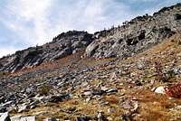 Upper subalpine vegetation
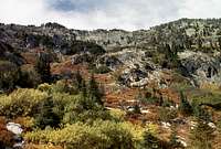 Hard Butte colors
Extreme elevations and abrupt topography give the Grassy Mountains many diverse vegetative communities; however with the drier continental climate, the diversity is less than neighboring Idaho mountains just to the north. Still there are eight species of conifer trees and a few broadleaf species. Nonforest vegetation communities include assorted grasslands, subalpine and the extensive moist meadows that are filled with grasses, sedges, and assortments of wildflowers and often willow thickets.
The lowest elevations along the Salmon River on the north margin support dry grass and shrubland habitats including Mountain Mahogany and sage brush. Intermixed with these and general at lower elevations elsewhere ponderosa pine and Douglas fir dominates. Slightly higher the forest turns to fir and larch primarily. The fir trees are interesting in that this region is a zone of genetic transition between grand fir and concolor fir. Typical grand fir is more common to the north, while concolor fir is more common south, but both species can be found with extensive forest areas covered by trees showing various degrees of hybridization between the two.
In the higher elevations the dominant tree is usually lodgepole pine with Englemann spruce and subalpine fir. Often the moister drainages and positions will be dominated by the latter two species, while other areas will be covered with an often homogenous layer of the lodgepole pine. These pine trees dominate areas that burn and often invade like weeds after the fire, while it’s hard to find them in areas that do not typically burn. All of these species can be found in low elevation cold pockets as well. Subalpine fir also reaches the mountain tops where the whitebark pine is also found. Whitebark pine is greatly reduced from historic levels due to fire suppression, introduced disease and bug kills.
At the higher elevations mountain parklands break up the forest vegetation with open glades of grasses and high elevation forbs. Some gravel/scree/rock plant communities can also be found, especially on the highest peaks that may hold snow late into the summer. True alpine does not occur in the Grassy Mountains since they don’t quite reach adequate elevation and the soil development is poor or absent on the peaks. Many areas at mid to high elevation in these mountains have burned in the past 20 years leaving spectacular open fields of wildflowers behind.
Unique elements
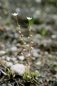 Global endemic
Over 1,500 plant species occur on the Payette National Forest, with several hundred of these found in the Grassy Mountains. Some are quite rare for a variety of interesting reasons. Orchids such as lady slippers are widespread in distribution, but very sparse in occurrence due to limitations in the species’ biology and sometimes loss of habitat. Distributional anomalies are found with some species occurring west in the Cascade or Sierra Mountains as well as central Idaho. Examples of these include, swamp onion (Allium validum), alpine saxifrage (Saxifraga tolmiei ledifolia), alpine buckwheat (Eriogonum pyrolifolium coryphaeum), rough bellflower (Campanula scabrella) and others. Then there are endemic species that occur in these mountains and no where else on earth. The best local example is Tobias' saxifrage (Saxifraga bryophora tobiasiae), which grows in seasonally moist granitic soil on only a few summits in the Grassy Mountains. Additional endemic species have been found on other mountains of the Payette National Forest, but to date they are not known to occur in the Grassys.
Fauna
Wildlife
 Elk habitat
The Grassy Mountains provides habitat for numerous wildlife species including whitetail deer, mule deer, elk, mountain lion, bear, coyote, moose, mountain sheep, and mountain goats. Smaller animals and birds include the river otter, snowshoe hare, beaver, marmot, osprey, and grouse. Rare species include the bald eagle, boreal owl, and whiteheaded woodpecker. Wolves were reintroduced in central Idaho in the mid-1990s and the populations have reached high levels and produced no shortage of controversy including some decline in game species and hundreds of head of livestock being killed over recent years.
In the Grassy Mountains the wildlife most likely to be encountered would be deer and occasionally moose and perhaps bighorn sheep in the northern reaches that forms the walls to the Salmon River Canyon. And as always the peaks will be covered with noisy little pikas scolding the humans for invading their neighborhood.
Fish
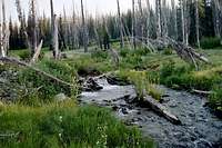 Stream near Granite Mt.
Historically most of the fish in this area would have been anadromous salmon and steelhead in the major rivers and streams. These fish are born in the small streams then migrate to the Pacific Ocean to grow and mature. In four or five years they return to the streams of their birth to reproduce before they die. Sockeye Salmon once entered the Payette system to spawn in the tributaries to Payette Lake. Dams, over fishing, habitat loss and many other factors have resulted in serious declines in populations or extinctions in the case of the Sockeye. Today occasional fishing seasons are allowed for Salmon depending upon yearly returns. There is a yearly Steelhead season on the Salmon River with fish generally weighing between 6 and 18 pounds. When such seasons are on, expect the Salmon River to be very crowded. If you don’t fish, it can be very exciting to simply observe these large anadromous fish spawning in some of the larger streams that drain into the Salmon River or the smaller kokanee salmon spawning in streams that feed Payette Lake to the south.
The many streams throughout the mountains contain westslope cutthroat trout, bull trout, whitefish and other species that are native or introduced. Westslope cutthroat trout are commonly about 12 inches, but can reach 18 inches. Bull trout can range well over the 10-pound mark. Bull trout have resident, fluvial and ad fluvial forms in many lakes, rivers and streams in the area. Generally fishing is restricted to catch and release or very limited harvest so be sure to consult the fishing regulations to know the details before selecting your intended destination. The anadromous species and bull trout are all federally listed under the Endangered Species Act and the catching or harassment of these species is not generally allowed except for closely managed situations (generally fishing seasons) controlled by the responsible agencies. Be informed because federal fines for violating the ESA can be thousands of dollars and some of the listed fish are easily confused with species that are legal to kill.
There are many mountain lakes in the Grassy Mountains, but few had fish historically. Today many are periodically planted with trout to add a fishing experience to those who enter the mountains. Species stocked have been cutthroat trout, rainbow trout, brook trout, grayling and various trout hybrids. Some of the lakes have special management situations so again it is wise to review the regulations before planning to fish in these lakes.
Lakes
 Small unnamed lake on the east side of Slab Butte
There are at least 66 lakes and larger ponds found within the Grassy Mountains. Almost all of these are situated in high mountain cirques or other glacial features. There are also reservoirs such as Goose Lake, Brundage Reservoir, Granite Lake, and Twin Lakes that provide good camping and recreational opportunities. Generally the reservoirs are accessible by vehicles, whereas the natural lakes are not. The following table lists the natural mountain lakes.
 Upper Twin Lake Upper Twin Lake Rainbow Lake Rainbow Lake Hard Butte Lake Hard Butte Lake Hazard/Lower Hazard Hazard/Lower Hazard Hard Creek Lake Hard Creek Lake Lloyds Lake Lloyds Lake Grass Mountain Lakes Grass Mountain Lakes (N. Fk. Pete Ck (N. Fk. Pete Ck |
|
Upper Hazard LakeFrog LakeMacHan Lake (east Slab) (east Slab) (Granite Mt.) (Granite Mt.) (lower S. Fk. Pete Ck) (lower S. Fk. Pete Ck) (middle S. Fk. Pete Ck) (middle S. Fk. Pete Ck) |
Camping
East side campgrounds
Accessed of the Warren Wagon RoadThree Mile Creek Campground
This campground is located a few miles north of Burgdorf and is also the trailhead most used to access Bear Pete Mountain. For some reason this campground is not listed under the campgrounds on the Payette National Forest website.
Upper Payette Lake Campground
To reach this campground travel sixteen miles north of McCall on Warren Wagon Road then turn left to Forest Road #495. There are nineteen campground units. Six of them are double units. All have tables, fire rings, handicapped accessible toilets, drinking water through two centrally located hand pumps and hosts, pack in/pack out. The campground also has a group area with 5 sites. In addition to the first come, first served sites, sites at Upper Payette Lake are available for reservation through the Reserve USA website www.ReserveUSA.com or by calling (877) 444-6777.
Jeanette Creek Campground
This campground is thirty-one miles north of McCall on the Warren Wagon Road, and three miles north on Forest Road #246. The small campground has 6 sites, toilets, tables, fire rings, there is trail access, pack in/pack out, but no drinking water.
Chinook Campground
Go thirty-nine miles northeast of McCall on Warren Wagon Road. There are nine campsites with tables, fire rings/grills, toilets, pack in/pack out, but no drinking water. This campground not directly in the Grassy Mountains, but is very close by.
Burgdorf Campground
To reach this campground, go thirty-one miles north of McCall on Warren Wagon Road, then two miles north on Forest Road #246. There are five sites, sewer hookup, drinking water, handicapped accessible toilet, pack in/pack out. There will be hosts at this campground.
West side campgrounds
Accessed off Goose Creek and Brundage RoadsHazard Lake Campground
To reach this campground from McCall, travel 5 miles northwest on Hwy 55 to Goose Lake Road (Brundage Mountain Ski Area turnoff), then turn right and go 22 miles north on Goose Lake Road. There are 12 campground units with trail access, tables, toilets, fire grates, and drinking water through one centrally located hand pump, non-motorized boating and fishing. There are hosts at Hard Creek Guard Station, two miles south of campground.
Grouse Campground
To reach this campground from McCall, go 5 miles northwest on Hwy 55 to Goose Lake Road (Brundage Mountain Ski Area turnoff), then turn right and go 9 miles north on Goose Lake Road. Turn left at the Grouse Campground sign on to Road #273, and drive a quarter of a mile to the campground entrance. There are 22 campground units, with an ADA compliant water hand pump and vault restrooms, tables and fire rings. A host is on site as well. There is a day use site with tables and fire grates, and parking for the boat launch in to Goose Lake (a motorized no-wake lake). In addition to the first come, first served sites, sites at Grouse campground are available for reservation through the Reserve USA website www.ReserveUSA.com or by calling (877) 444-6777.
Other camping opportunities
At-large camping is generally allowed throughout the forest for those wanting to camp out of their vehicle and away from the campgrounds. Particularly good places for this are at Goose Lake, Brundage Reservoir, Granite Lake, Fisher Saddle, Elk Meadows and just about anywhere a good pullout from the forest roads can be found. Opportunities for back packers are nearly endless at the many remote lakes and mountain meadows.
A different sort of lodging opportunity is also available in the form of private cabins at the Burgdorf Hot Springs. http://www.idahohotsprings.com/destinations/burgdorf/index.htm
http://www.secesh.net/Burgdorf.htm
These cabins are very rustic and may not include everything you need, so call ahead for information.
 Good camping in the basin north of Hard Butte. Hard Butte Lake
Red Tape
There are no fees to use any of these public lands. Some of the trails are open to motorized vehicles, while others are not. If you intend to use a motorized trail, or want to avoid one, refer to the standard forest map, which indicates whether a trail is motorized or not. These maps are available for $6 at any of the local Forest Service offices. Also this information is generally available at campground kiosks and trailheads.Additional Information and Current Conditions
Current conditions and access information can be obtained from the New Meadows Ranger District office of the Payette National Forest.USDA Forest Service
Payette National Forest
800 West Lakeside Ave
McCall ,Idaho 83638
(208) 634-0700
McCall District Ranger Office
Payette National Forest
102 West Lake Street
McCall, Idaho 83638
(208) 634-0400
New Meadows District Ranger Office
Payette National Forest
PO Box J
3674 Highway 95
New Meadows, Idaho 83654
(208) 347-0300
Refer to individual mountain pages in this group for more detailed information.
NOAA Forecast