
|
|
Mountain/Rock |
|---|---|
|
|
45.17610°N / 116.1188°W |
|
|
Idaho |
|
|
Hiking, Bouldering, Scrambling |
|
|
Summer, Fall |
|
|
8607 ft / 2623 m |
|
|
Overview
 The north side of Bruin Mountain, south and Upper Hazard Lake
There may be some confusion as to which peak is Bruin Mountain as different maps give different peaks the name. USGS quad maps list the northern peak, which is the higher of the two at 8,767 feet as Bruin Mountain, but the Payette National Forest map gives the name to the southern peak, which is 8,607 feet. Also the southern peak has an official brass cap on the summit labels as Bruin Mountain. The quickest routes to the peaks are separate, but the summits can be climbed together if desired. The connecting ridge is generally an easy traverse, but the north slopes from the southern peak onto the ridge can be tricky or dangerous in places and there are some difficult rocks between the peaks to negotiate. The northern peak has prominence of 1,627 feet, while the southern peak has 387 feet of prominence and is one mile away. For our purposes, they are here referred to as Bruin Mountain, north and Bruin Mountain, south. This page is for Bruin Mountain, south.
The view from the summits takes in the Long Valley below McCall to the south, endless Salmon River Mountains to the east and the Hazard Lakes to the north. In the distance down the long U-shaped glacial valleys, the Salmon River Canyon and the Slate and Gospel Hump Mountains beyond are seen. The furthest view is probably to the west where the Seven Devils, Wallowa Mountains and even the more distant Elkhorn Mountains can be seen if the air is clear and you know just where to look. Much of the surrounding spruce and subalpine fir forest was destroyed during the severe 1994 fire season when approximately 400,000 acres burned here. The skeletal forests cover nearly the entire landscape, but small pockets of unburned forest are present in some of the moist valleys and in isolated protected positions on the higher summits where the lighter fuels wouldn’t carry the fire.
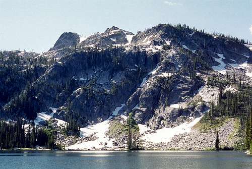
 The north side of Bruin Mountain, south as seen from Bruin Mountain, north
Though not as high as its northern neighbor, the southern peak of Bruin Mountain is the more exciting of the two. It is composed of a northwest - southeast running ridge with two broad summit points, the southernmost being slightly the highest. The summit is formed of giant granite blocks that must be hopped for quite some distance to reach the top. The north face is a spectacular series of cliffs that generally can only be climbed by technical routes, though there are a few steep couloirs that appear to provide challenging scrambles. Extensive snow fields hug the north slope at the foot of the cliffs. These may survive through the summer to winter on cooler years.
 |
 |
 |
Getting There


Turn north onto the Brundage Mountain Ski Area road (Forest Service Road 257) off of Highway 55. This road is also signed as the Goose Lake Road. Coming from the north, this is a left turn 0.4 miles south of mile marker 150 and approximately 6.6 miles east of New Meadows. From the south this is a right turn 0.6 mile past mile marker 149. Stay on the main road for 7.1 miles, and then take the right turn on road 281 to Brundage Reservoir. Continue for 3.3 miles and then take the left turn (still 281) immediately before Slater Meadow.
Continue on road 281 for approximately six miles to its end at Fisher Saddle. From Fisher Saddle simply climb the east ridge to the summit. For the first one third mile the slope is very gentle, but then rises abruptly for nearly 1,000 feet to reach the east shoulder of the summit ridge. From there it’s a short walk through open, stunted white bark pine followed by extensive hopping of large granite boulders to reach the two summit points. The distance from Fisher Saddle is approximately 1.5 miles.
The summit can also be reached from the west via the 169 and trail. This route takes the 257 rd from Highway 55, but does not turn off on the Brundage Reservoir road 281. Instead continue 19 miles from highway 55 to the Hard Creek trailhead. From here the trail heads east and reaches Hard Creek Lake after about two miles. Continue just a little more to the east to the saddle above Upper Hazard Lake. From the saddle climb the west ridge to the summit of Bruin Mountain, south.
Red Tape
NoneCamping

The nearest developed campground is the Hazard Lake Campground on road 257. This campground is handy for Bruin Mountain since that is where the trailhead is. Hazard Lake Campground is approximately 21 miles north from Highway 55. There is also good camping at Goose Lake Campground at the south end of Goose Lake or the excellent dispersed campgrounds found along the east shore of the lake. Goose Lake is about 10 miles north of Highway 55. There is also some dispersed camping to be had along Brundage Reservoir as well. For backpackers there are camping opportunities at Upper Hazard Lake, Hard Lake, Hidden Lake or any number of miscellaneous meadows or other suitable areas around the peaks.
When to Climb
June until the late fall snows get deep (Oct. or Nov). The road is not maintained beyond the ski resort in the winter, thus getting to this area would require snowmobiles.Mountain Conditions and Additional Information

Current conditions and access information can be obtained from the New Meadows Ranger District office of the Payette National Forest.
New Meadows District Ranger Office
PO Box J
3674 Highway 95
New Meadows, Idaho 83654
(208) 347-0300
NOAA Forecast