
|
|
Mountain/Rock |
|---|---|
|
|
45.09230°N / 116.1416°W |
|
|
8225 ft / 2507 m |
|
|
Overview
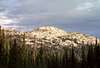
Slab Butte is an imposing block at the southern end of the Grassy Mountains, which is a sub-range forming the northwest portion of the extensive Salmon River Mountains. It is formed of granite that is decomposing into large slabs, which gives the mountain its name. These crumbling blocks lay in vertical orientation and fall away in plates giving the mound an edge-on appearance and extensive talus slopes at the base. The long north-south situated ridge gives routes to the top, but these require slow negotiation of the jumbled rock. The west and east faces are vertical over much of the mountain, but non-technical scramble routes can be found.
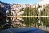
Most people pass by this mountain and scarcely notice it while on their way to other destinations such as larger mountains, the extensive back country trial system, Hazzard Lakes and more to the north. From the west it is generally not even visible from much of the main travel route due to the steeply rising forested base. Nor are there any trails to the mountain or either of the two small lakes that sit one each on the west and east side. But access is easy through open slopes on fairly gentle terrain on the east side and the long southwest ridge.
 |  |  |  |  |
Getting There
Turn north onto the Brundage Mountain Ski Area road (Forest Service Road 257) off of Highway 55. Coming from the north, this is a left turn 0.4 miles south of mile marker 150 and approximately 6.6 miles east of New Meadows. From the south this is a right turn 0.6 mile past mile marker 149. Stay on the main road for 7.1 miles, and then take the right turn on road 281 to Brundage Reservoir. Continue for 3.3 miles and then take the left turn (still 281) immediately before Slater Meadow. Continue on road 281 for 1.0 mile and take a left turn. This road bends south for 0.3 mile before making a hairpin curve back to the right where there is an earth barrier. This is the parking spot.
From the parking spot walk north beyond the barrier. To the left will be an old clearcut that has 15-20 foot tall trees in it. You will leave this road at the point where this logging unit ends and the road makes a gradual curve to the right. The forest on the left will now be older timber. Depending on how fast you walk, this point is 10-15 minutes from the parking area. Cut through this fairly open forest to the northwest for a short distance and emerge into a large meadow. Near the northwest corner of the meadow the slope will increase slightly, become rocky and support a stand of short aspen. Head for that then continue straight up the open slope beyond for the most direct route or contour around slightly to the right to pass on the gentlest slope. There isn’t a big difference and from here there is no best way to go, but with the mountain clearly in site one just needs to walk to it. The best way is to aim for the open spot to the left of the mountain to have the easiest terrain and to come out at the small lake at the southeast foot of the mountain.
To reach the west foot of the mountain, continue on the 257 road north from the Brundage Reservoir turn until it meets Goose Lake. The mountain rises east of Goose Lake, but is not visible from it. There are likely many routes to the mountain, but perhaps the best starts where the 257 road first meets Goose Lake. Park here and hike the low, gentle and poorly defined ridge straight north. After nearly a mile the ridge becomes even less defined and turns east. Eventually this ridge will form again and meet the main ridge south of Slab Butte. If this route is chosen, be sure to take a good topo map and be prepared to find your own way. The info given here is from a distant observation and map reading only.
 |  |  |
Red Tape
None.
When To Climb
June until the late fall snows get deep (Oct. or Nov). The road is not maintained beyond the ski resort in the winter, thus getting to this area would require snowmobiles.
 |
Camping
The nearest developed campground is the Hazard Lake Campground on road 257, approximately 21 miles north from Highway 55. This is not very close to Slab Butte. Excellent dispersed campgrounds can be found along the east shore of Goose Lake at the west foot of the mountain. There is also some dispersed camping to be had along Brundage Reservoir as well. On the mountain itself, the pond at the eastern foot of the giant granite slab offers nice camping that is only a long mile cross country hike from the nearest road.
 |  |
Mountain Conditions
Current mountain conditions and access information can be obtained from the New Meadows Ranger District office of the Payette National Forest, (208) 347-0300.
NOAA Forcast