
|
|
Mountain/Rock |
|---|---|
|
|
45.16360°N / 116.1956°W |
|
|
Idaho |
|
|
Hiking, Scrambling |
|
|
Summer, Fall |
|
|
8156 ft / 2486 m |
|
|
Overview
 The north side of Peak 8,156. Super photo by Super Dave
 Grass Mountain from Slab Butte
 North Summits of Grass Mountain
 Grass Mountain From Granite Mountain
 Grass Mountain from Bruin Mountain
The subjects of this page should not be confused with the overall Grassy Mountains Area Page, which covers the westernmost sub-range of the vast Salmon River Mountains of central Idaho. That sub-range gets its name from a small, closely associated group of lower summits collectively known as Grass Mountain that is situated on the western boundary of the group. “Grass Mountain” in this sense includes approximately eight summits, closely grouped within a two by three mile area. This page is for the central point, which is only the second highest, but is the hub both physically and access-wise for all the summits. This summit along with its near neighbors is not among the higher summits of the Grassy Mountains sub-range, but still rises approximately 5,000 feet over the Little Salmon River to the west and over 2,200 feet over upper the upper Hard Creek basin to the east. This basin wraps around the mountain so all slopes fall into one of its tributaries. The mountain has 336 feet of prominence.
These mountains are formed of granite plutons of the Idaho batholith that resulted from the subduction related to the accretion of the Wallowa/Seven Devils Terrane approximately 120 million years ago. Alpine glaciation of the Pleistocene transformed the area into sharp peaks above cirques dotted with numerous lakes and carved valleys. Most of these formations are on the north facing slopes where snow deposition would have been heaviest.
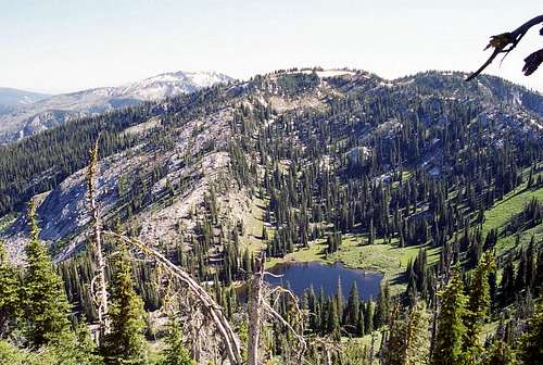
There are seven subalpine lakes within the closely approximate peaks of Grass Mountain, three of which are found in the basins adjacent Peak 8,156. These are the two Grass Mountain Lakes in the north cirques and Frog Lake in the large cirque that separates this mountain from the slightly higher, but less sculpted Peak 8,180. Of all the lakes in the vicinity, the Grass Mountain Lakes get the most use by far due to their spectacular setting and close easy access. Don’t expect privacy here, but you can probably find it at Frog Lake.
The area is not designated wilderness, though it has that feel once away from the access roads. Much of it is managed for primitive recreation, though some areas allow motorized use and livestock grazing. Contact the local Forest Service offices (see additional information) for more information on if these are potential concerns.
Getting There
 The west ridge is the best way to hike to this summit
The main access to Grass Mountain is the Grass Mountain Lake trailhead for Trail 163. To reach this trailhead from McCall, travel five miles northwest on Highway 55 and turn right (north) on the Goose Lake Road (Brundage Mountain Ski Area turnoff), and then drive approximately 20 miles to the trailhead. From the trailhead it’s about a two mile hike into the two Grass Mountain Lakes, which offer good camping and a central base to explore the multiple summits in the area. To get to the summit of Peak 8,156 continue west on the trail to the pass west of the lakes, then turn south along the ridge. After a short distance turn east onto the summit ridge and proceed to the top. It’s a very straightforward and easy route. A more challenging route would be a scramble up from the lakes on the north face of the mountain. There are several lines one can take, but there will be scree, brush or cliffs so plan out a line carefully taking your abilities into consideration.
Red Tape
There are no fees to use any of these public lands. Some of the trails are open to motorized vehicles, while others are not. If you intend to use a motorized trail, or want to avoid one, refer to the standard forest map, which indicates whether a trail is motorized or not. These maps are available for $6 at any of the local Forest Service offices. Also this information is generally available at campground kiosks and trailheads.Camping
 Grass Mountain Lakes from the pass to the west
At-large camping is generally allowed throughout the forest for those wanting to camp out of their vehicle and away from the campgrounds. Particularly good places close to the Grass Mountain vicinity include Goose Lake, Brundage Reservoir, and just about anywhere a good pullout from the forest roads can be found. Opportunities for back packers are nearly endless at the many lakes and remote meadows found at the several lakes and meadows found around the summits of Grass Mountain.
For those wanting a developed campground, Hazard Lake Campground and Grouse Campground are not far. To reach this Hazard Lake Campground from McCall, travel 5 miles northwest on Hwy 55 to Goose Lake Road (Brundage Mountain Ski Area turnoff), then turn right and go 22 miles north on Goose Lake Road. There are 12 campground units with trail access, tables, toilets, fire grates, and drinking water through one centrally located hand pump, non-motorized boating and fishing. There are hosts at Hard Creek Guard Station, two miles south of campground, which is very close to the Grass Mountain Lakes trailhead.
To reach Grouse Campground from McCall, go 5 miles northwest on Hwy 55 to Goose Lake Road (Brundage Mountain Ski Area turnoff), then turn right and go 9 miles north on Goose Lake Road. Turn left at the Grouse Campground sign on to Road #273, and drive a quarter of a mile to the campground entrance. There are 22 campground units, with an ADA compliant water hand pump and vault restrooms, tables and fire rings. A host is on site as well. There is a day use site with tables and fire grates, and parking for the boat launch in to Goose Lake (a motorized no-wake lake). In addition to the first come, first served sites, sites at Grouse campground are available for reservation through the Reserve USA website www.ReserveUSA.com or by calling (877) 444-6777.
Additional Information and Current Conditions
 Frog Lake and Peak 8,180
Current conditions and access information can be obtained from the New Meadows Ranger District office of the Payette National Forest.
USDA Forest Service
Payette National Forest
800 West Lakeside Ave
McCall ,Idaho 83638
(208) 634-0700
New Meadows District Ranger Office
Payette National Forest
PO Box J
3674 Highway 95
New Meadows, Idaho 83654
(208) 347-0300
NOAA Forecast
 The north side of Peak 8,156 of Grass Mountain