
-
 4157 Hits
-
 79.54% Score
-
 11 Votes
|
|
Mountain/Rock |
|---|---|
|
|
49.14322°N / 7.76550°E |
|
|
Trad Climbing, Sport Climbing, Toprope |
|
|
Spring, Summer, Fall |
|
|
817 ft / 249 m |
|
|
Overview
 Büttelwoogfelsen above the Büttelwoog Campground Büttelwoogfelsen above the Büttelwoog Campground |
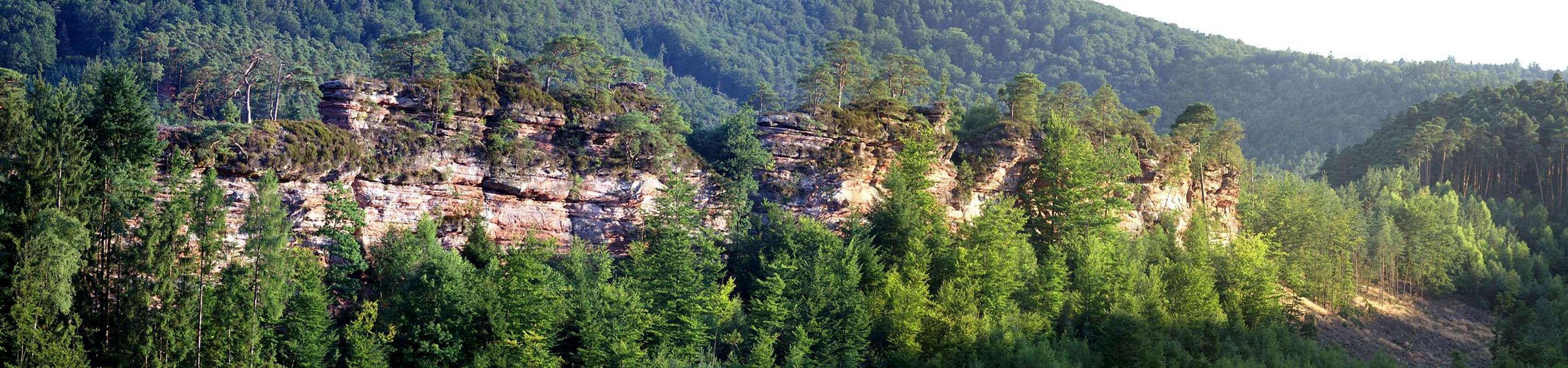
To the west of Dahn, a town in the centre of the Felsenland (Rock Country) of the Südpfalz Climbing Area there are half a dozen sandstone ridges aligned side by side to each other and running east to west. The northernmost is the ridge of the three Schillerfelsen, the southernmost one the two crag ridge of Durstigfels. Some of the formations are big and impressive, some are outright famous, some are crowded and popular.
 |  |  |  |
Right in the centre you can find the longest of the cliffs: Büttelwoogfelsen. It stretches between two residential streets and thus rises out of the backyards of the local residents. It is a low ridge - unlike any other in the greater Südpfalz area, where you usually have to climb a mountain to get to the sandstone. Here the cliffs start at backporch level and rise for as little as 20m. On the other hand access is very easy. One of the Dahn campgrounds is located directly to the north of the ridge and the tent-to-rock approach doesn't take more than five minutes. Yet, most climbing activity concentrates on the south faces of Blitzfels, Klammpfeiler and Rotgraue Wand, right across the Büttelwoog valley. Southern exposure, good rock quality with securely bolted route draw all kinds of climbers there. At the same time the Büttelwoogfelsen remain empty.
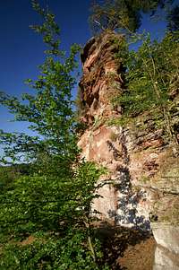 |  |  |  |
On Büttelwoogfelsen four towers are distinguished, first through fourth, all of which offer one or two handful of routes of medium difficulty. Most routes were established on the higher north faces, while the low south faces remain overgrown and undeveloped. The first ascents were done in the late 1960s / early 1970s by changing teams of Hans Laub, Reiner Braun and Albert Friedrich.
Climbing Routes on Büttelwoogfelsen
 Büttelwoogfelsen second tower
The towers of Büttelwoogfelsen are among the less popular formation in the greater vicinity of Dahn. Thanks to their small size and overgrown access trails but mainly thanks to better and bigger cliffs nearby the towers were only climbed as late as the late 1960s / early 1970s. Three climbers established almost all but two routes on the crags: Hans Laub, Reiner Braun and Albert Friedrich - in all possible combinations of two man teams.
The following table has links to the tour database of the PK, where you can find the grades for the free routes plus additional information. Here is the link to the complete route database.
| Feature | Routes link | Summary |
| Erster Turm | First Tower | 10 routes with variations ranging from 1 - 5+ |
| Zweiter Turm | Second Tower | 5 routes with variations ranging from 2 - 5+ |
| Dritter Turm | Third Tower | 7 routes with variations ranging from 1 - 5- |
| Vierter Turm | Fourth Tower | 4 routes with variations rated 1 through 5+ |
Getting There
  |
The towers of Büttelwoogfelsen are located at the western outskirts of Dahn, between two residential streets. Dahn is located right in the middle of the Pfälzerwald area and access routes are rather long. The closest airports are Frankfurt and Stuttgart.
From Frankfurt
There are two possible routes which both take equally long
- Via Ludwigshafen
- From Frankfurt take motorway A5 southward to Darmstadt.
- There change to A67 south.
- At Viernheimer Dreieck turn onto A6 west.
- Leave it at Frankenthaler Kreuz for A61 south.
- At Mutterstädter Kreuz take A65 south until you reach Landau.
- At Landau turn on B10 west.
- At Hinterweidental turn onto B427 south which will take you to Dahn. In the town centre a sign leads to Felsenland Badeparadies, the public open air pool. Park at the pool parking lot. To reach Braut und Bräutigam just head back the street (Hasenbergstrasse) until you reach the formation.
- From Frankfurt take motorway A5 southward to Darmstadt.
- Via Kaiserslautern
- From Frankfurt take motorway A3 west
- At Mönchhofdreieck turn onto A67 south
- At Rüsselsheimer Dreieck take A60 west
- At Kreuz Mainz Süd take A63 south
- At Kreuz Kaiserslautern turn onto A6 west
- At Kreuz Landstuhl turn onto A62 south
- At Pirmasens turn onto B10 east
- At Hinterweidental take B427 south to Dahn
- From Frankfurt take motorway A3 west
From Stuttgart
- Take motorway A8 to Karlsruhe
- At Karlsruher Dreieck turn north onto A5
- Tke the next exit to head for A65
- At Kandel you can leave onto B427 which will lead you directly to Dahn. However the detour to Landau and B10 will take less time as the roads are better (three or four lanes)
Red Tape
 Dactylorhiza maculata
 Yes, there is red tape and lots of it. The sandstone of Südpfalz forms lots of caves and overhangs. Though this makes it most interesting for climbers, two species of birds of prey compete for this habitat: the peregrine falcons and the eagle owls. Both are endangered and wherever there is a eagle owl pair found nesting in the sandstone the crag will immediately be closed. Generally this closure lasts from the beginning of each year through Aug. 1st. If breeding is not successful the closures will be cancelled even before that date. For a list of closures see the Closure List of PK. The Schillerfelsen are so close to the nearest houses of Dahn, that usually birds don't nest there. However, please adhere to "stop signs" if there are any.
The use of magnesia is not allowed in the whole Südpfalz region. This is rather a directive or an arrangement than an outright law. Thus you probably will get away with using it but do so only when absolutely necessary. Magnesia closes the pores which you find in the sandstone and together they form a smooth surface which will get very slippery in wet conditions. The rule of thumb is to use magnesia in the highest difficulty sections and only extremely sparingly.
A list of guidelines can be found here (in German).
Parking: The parking lots near the public pool of Dahn are free. However, they are not public and you shouldn't stay after nightfall.
Accommodation
In the town of Dahn you can find numerous hotels or apartments. Have a look at the tourist information site for more info.The closest accommodation possibilities are the Youth Hostel (near Wachtfels, 100m to the east), the Felsenland Hotel (200m down the street) and the Büttelwoog Campground (another 300m behind the hotel and directly to the north of Büttelwoogfelsen).
Weather Conditions
Maps & Books
Maps
As for maps there is a good overview map (1:50000) by Kompass Verlag but the best ones are the official topographic maps by the state government of Rheinland Pfalz, scaled 1:50000, 1:25000 and 1:5000. All official maps can be found on the web page of Landesvermessungsamt Rheinland Pfalz
1:50000
- Naturpark Pfälzer Wald
Kompass Map WK766
ISBN: 3-85491-523-3
- Pirmasens Süd<
LVA RLP Map L6910
ISBN: 3-89637-193-2
1:25000
- Dahn
LVA RLP Map 6812
ISBN: 3-89637-147-9
Books
There are a number of climbing guidebooks on the region of Südpfalz. The best ones, however, have been published privately and are sold only in selected bookshops of the region.
- Hiking
- Pfälzerwald
B. & J.-Th. Titz
Rother Verlag
ISBN: 3-7633-4268-0 - Klettern im Buntsandstein
U. Daigger, H.-J. Cron
Westpfälzische Verlagsdruckerei St. Ingbert
ISBN: 3-00-0155457-4
- Pfalz - Klettern im Buntsandstein des Pfälzer Felsenlands
J. Richter, S. Tittel
Panico Alpinverlag
ISBN: 978-3-936740-41-7
- Pfalz ++, Klettern im Buntsandstein
R. Burkard, P. Weinrich
Published privately
- Klettern im Naturpark Pfälzerwald
Naturfreunde Lambrecht
Published privately - Pfalz & Nordvogesen en bloc
A. Wenner, Y. Corby, I. Bald
Panico Verlag
ISBN: 3-936740-19-4
 Climbing Guidebook |
Climbing