
-
 7563 Hits
-
 81.72% Score
-
 14 Votes
|
|
Mountain/Rock |
|---|---|
|
|
49.18625°N / 7.84583°E |
|
|
Sport Climbing, Scrambling |
|
|
Spring, Summer, Fall, Winter |
|
|
303 ft / 92 m |
|
|
Overview
 Hauensteiner Puppe Hauensteiner Puppe |
Until quite recently I used to think that the town of Dahn was the climbing capital of the Südpfalz Region (also called Wasgau) being surrounded by numerous impressive sandstone climbing crags. From this week on I have to admit that there is a close contender for that title, the town of Hauenstein some 10km further to the east. Though I had already been there two years ago and though I had seen lots of sandstone cliffs somehow I always passed by the town on my way to Dahn. Hauenstein is set back a little from the access road B10 which may account for my lack of interest but thanks to a renewed visit - and a glimpse at the hundreds of routes which are published by the Vereinigung Pfälzer Kletterer I had to change my attitude.
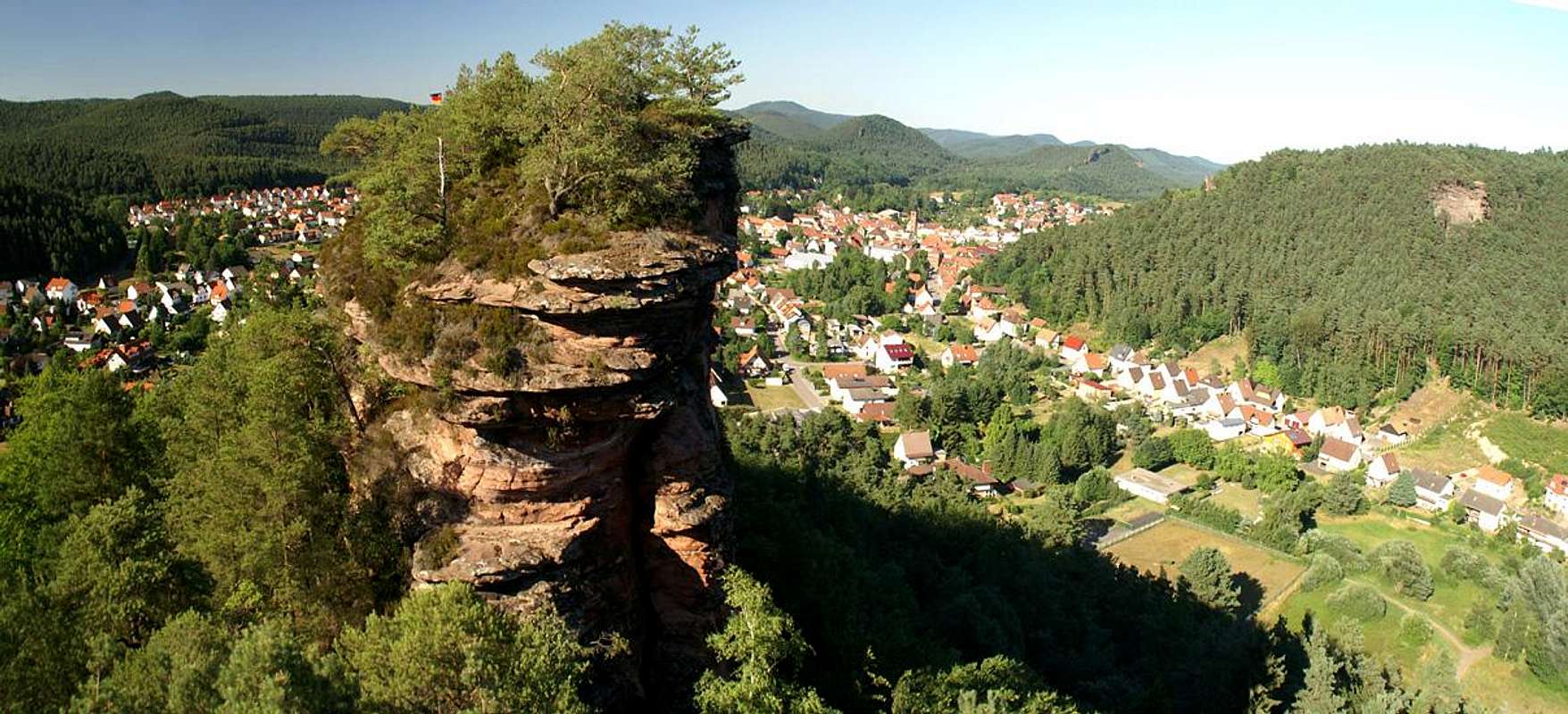
Close to the town centre - to the south - you find the large cliff of Burghaldefels, a 1km long ridge rising out of the dense Pfälzerwald forest. It is split in (at least) three parts - the southern summit, a lonf cliff coming forth out of the surrounding hills, the main summit - a huge crag with 50m vertical walls on all sides and the little but exquiite Hauensteiner Puppe, a standalone tower to the north of the whole formation. As seen from Hauenstein - or one of the surrounding other cliffs, Burghaldefels rises out of the forest like a ship's prow but an old photo I found while preparing the page shows that the dense forest has only grown that high in recent years. Obviously there have been repeated efforts to free the cliff from its vegetation as the Hauensteiner Puppe is one of the landmarks of the town.
 www.hauenstein.de |
The German word Puppe means doll and most likely in this case is derived from the pieces you use for certain board games. The tower closely resembles these with its round head and conical body. However, you also might be reminded of a bowling pin. Hauensteiner Puppe is closely related to the climbing history of the region. Together with other spectacular crags it was first climbed by two brothers, Fritz and Theo Mann, in the decade between 1910 and 1920. Today, 5 routes are known ranging in difficulty between 3 and 6.
However, apart from the spectacular tower the majority of routes can be found on the two further summits of Burghaldefels. Though starting with a difficulty of 2 the most serious one reach grades of 9, 9+ and 10. They are called "Magnetfinger" (9), "Fire, Ice and Dynammite" 9/9+ or "ZEC (ZZero Effort Climbing) 10. With all known variations there are approximately 100 routes of all difficulties.
While both the Hauensteiner Puppe and the main summit are out of bounds for hikers there is a back way which leads to the southernmost part of the south summit from where you can reach its top quite easily. However, reaching its front means to step over one or two deep chasms and a scramble along a somewhat exposed ledge. You'll reach a perfect lookout point (see the panorama) from where all (?) of Hauensteins sandstone cliffs can be seen.
|


Climbing Routes
  |
The following information is linked from the site of the Vereinigung Pfälzer Kletterer I link to their routes database directly with some summary info. Here is the link t the complete database.
| Region | Routes link | Summary |
| Hauensteiner Puppe | Hauensteiner Puppe | 5 routes with variations ranging from 3 - 6- |
| Burghaldefels | Burghaldefels | 81 routes with many variations ranging 3 - 10 |
|


Getting There
Burghaldefels is located south of the town of Hauenstein. From the town centre a sign leads to a large parking lot to the west of the cliff. Hauenstein itself, though close to the access road B10 is hidden from view by the Neding- (also a climbing cliff) and Mischberg mountains. The closest airports are at Frankfurt and Stuttgart so the itineraries start there too.From Frankfurt
There are two possible routes which both take equally long- Via Ludwigshafen
- From Frankfurt take motorway A5 southward to Darmstadt.
- There change to A67 south.
- At Viernheimer Dreieck turn onto A6 west. Leav
- e it at Frankenthaler Kreuz for A61 south.
- At Mutterstädter Kreuz take A65 south until you reach Landau.
- At Landau turn on B10 west.
- Take the exit Hauenstein after you have passed Wilgartswiesen.
- In the town centre turn right for a marked parking lot (look for signs).
- Via Kaiserslautern
- From Frankfurt take motorway A3 west
- At Mönchhofdreieck turn onto A67 south
- At Rüsselsheimer Dreieck take A60 west
- At Kreuz Mainz Süd take A63 south
- At Kreuz Kaiserslautern turn onto A6 west
- At Kreuz Landstuhl turn onto A62 south
- At Pirmasens turn onto B10 east
- Take the Hauenstein exit
From Stuttgart
- Take motorway A8 to Karlsruhe
- At Karlsruher Dreieck turn north onto A5
- Take the next exit to head for A65
- At Landau turn on B10 west.
- Take the exit Hauenstein after you have passed Wilgartswiesen.
Red Tape
Yes, there is red tape and lots of it. The sandstone of Südpfalz forms lots of caves and overhangs. Though this makes it most interesting for climbers, two species of birds of prey compete for this habitat: the peregrine falcons and the eagle owls. Both are endangered and wherever there is a eagle owl pair found nesting in the sandstone the crag will immediately be closed. Generally this closure lasts from the beginning of each year through Aug. 1st. If breeding is not successful the closures will be cancelled even before that date. For a list of closures see the Closure List of PK.The use of magnesia is not allowed in the whole Südpfalz region. This is rather a directive or an arrangement than an outright law. Thus you probably will get away with using it but do so only when absolutely necessary. Magnesia closes the pores which you find in the sandstone and together they form a smooth surface which will get very slippery in wet conditions. The rule of thumb is to use magnesia in the highest difficulty sections and only extremely sparingly.
A list of guidelines can be found here (in German).
Accommodation
In Hauenstein you can find quite a number of hotels and apartments. There are two websites, the firs of which gives a very good overview over any sort of accommodation (visit the link "Unterkunft".Besides from being the "secret climbing capital" Hauenstein is the "shoe capital" of the area due to its long history of shoemaking.
Weather Conditions
Hauenstein has its own weather forecast at weather.com:Maps & Books
Maps
As for maps there is a good overview map (1:50000) by Kompass Verlag but the best ones are the official topographic maps by the state government of Rheinland Pfalz, scaled 1:50000, 1:25000 and 1:5000. All official maps can be found on the web page of Landesvermessungsamt Rheinland Pfalz
1:50000
- Naturpark Pfälzer Wald
Kompass Map WK766
ISBN: 3-85491-523-3
- Bad Bergzabern
LVA RLP Map L6912
ISBN: 3-89637-194-0
1:25000
Books
There are a number of climbing guidebooks on the region of Südpfalz. The best ones, however, have been published privately and are sold only in selected bookshops of the region.
- Hiking
- Pfälzerwald
B. & J.-Th. Titz
Rother Verlag
ISBN: 3-7633-4268-0 - Klettern im Buntsandstein
U. Daigger, H.-J. Cron
Published privately and out of print
- Pfalz ++, Klettern im Buntsandstein
R. Burkard, P. Weinrich
Published privately
- Klettern im Naturpark Pfälzerwald
Naturfreunde Lambrecht
Published privately - Pfalz & Nordvogesen en bloc
A. Wenner, Y. Corby, I. Bald
Panico Verlag
ISBN: 3-936740-19-4
Climbing