
-
 16280 Hits
-
 87.76% Score
-
 25 Votes
|
|
Canyon |
|---|---|
|
|
37.74791°N / 111.45355°W |
|
|
Hiking, Bouldering, Scrambling |
|
|
Spring, Summer, Fall, Winter |
|
|
Overview
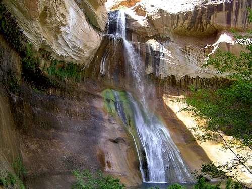
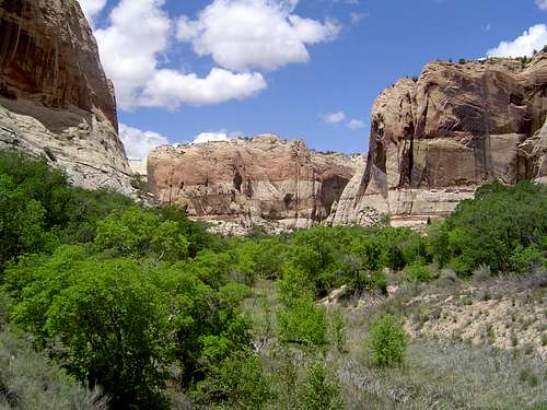
Calf Creek Canyon is an excellent distillation of Colorado Plateau geography. Tall Navajo sandstone cliffs, strange rock formations, lush riparian vegetation, Indian ruins, and a perennial stream with two gorgeous waterfalls are what one can expect from Calf Creek Canyon. Proximity to Utah Highway 12 and the ease of the hike to Lower Calf Creek Falls make this canyon a great introduction to the Grand Staircase-Escalante National Monument.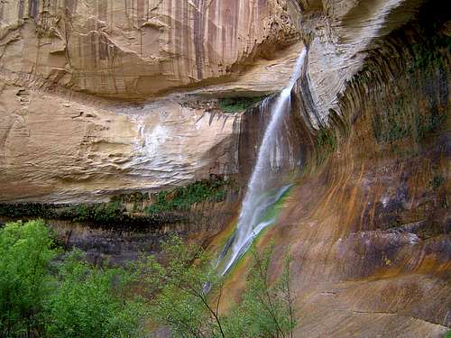 Lower Calf Creek Falls
 Calf Creek Canyon
The highlight of the canyon is its two fantastic waterfalls. Upper Calf Creek Falls is a slender 88 ft. waterfall with an emerald pool and a lush, wide canyon. Few people spend much time at this falls, although there is ample opportunity for exploring the canyon in isolation. The Upper Falls’ obscurity is due in large measure to its sibling downstream. Lower Calf Creek Falls is the real star of Calf Creek Canyon. Falling 126 ft, Lower Calf Creek Falls is perhaps the most elegant waterfall in the southwest. Falling a few feet over the initial precipice it then ricochets outward before falling onto the sloping sandstone below, where it cascades the rest of its way into the beautiful pool below. The entire display is very colorful. The whitewater contrasts sharply against the reddish sandstone and the green algae that has taken hold on the cliff walls. The pools beneath both falls are great for a quick dip. There is an additional pool adjacent to the one beneath Upper Calf Creek Falls.
The human presence in the canyon dates back to prehistoric times. There are a few small ruins hidden amidst notches in the cliffs below the Lower Falls. Following the arrival of American settlers, the canyon was used as a corral for cattle. The canyon’s name dates from this period. For many years Calf Creek Canyon was an unknown oasis in the midst of southern Utah’s sandstone country. In 1996 the Grand Staircase-Escalante National Monument was established. Since that time visitation has continued to increase. Nonetheless, people are still relatively few given the isolated location. Solitude is still easily acquired, especially as one ventures away from the Lower Falls.
The trail to the Upper Falls is very short and drops 600 ft. to the canyon bottom. From there, once can scramble downstream, despite the lake of an established trail. It is also possible to travel cross-country to the top of the falls or even to the west side of the canyon. The trip to the Lower Falls is a sandy 2.75 miles that dead-ends at the base of the falls. The cliffs are shear are there are probably several good opportunities for good climbing.
Geographic Context
Calf Creek Canyon is located in the northeastern section of the Grand Staircase-National Monument. The Monument is located near the center of the Colorado Plateau, a broad, roughly oval shaped area in Utah, Arizona, New Mexico and Colorado. Situated in southern Utah, the Grand Staircase-Escalante National Monument encompasses some of the most distinctive geography of the Colorado Plateau, an area known for distinctive geography.Geography of the Grand Staircase-Escalante National Monument
 The Grand Staircase: the Pink, White and Vermilion Cliffs
The Grand Staircase-Escalante National Monument can be divided into three distinctive regions. In the west is the Grand Staircase itself. Four parallel rows of cliffs, the Pink, Gray, White, and Vermilion Cliffs are so named because of the color of the rock they are composed of. The stone layers exposed in these cliffs extend eastward, through other parts of the Monument. The colorful formations of Bryce Canyon National Park are carved out of the Pink Cliffs, while the sandstone canyons of Zion National Park are carved out of the layers of the White Cliffs. The Vermilion Cliffs rise above the route to the North Rim of the Grand Canyon. This area contains the large Paria-Hackberry Wilderness Study Area. Canyons carved into the White Cliffs are found within.
The central portion of the Grand Staircase-Escalante National Monument is a broad highland called the Kaiparowits Plateau. This broad area contains numerous hills and ridges as it tapers off to the south. Its eastern edge is bordered by the Straight Cliffs, a roughly fifty mile long escarpment. Numerous Wilderness Study Areas are found on the Kaiparowits Plateau.
 Canyons of the Escalante
The Canyons of the Escalante River and its tributaries dominate the eastern section of the Monument. Calf Creek Canyon is found in this region. The Escalante River is named after Father Silvestre Vélez de Escalante, the Spanish Franciscan missionary who explored the region in 1776. The Canyons of the Escalante are not limited to the Grand Staircase-Escalante National Monument. Many of them, especially the Escalante River itself also flow into Glen Canyon National Recreation Area.
Phipps-Death Hollow Instant Study Area
Although the part of Calf Creek Canyon north of the campground is in the Calf Creek Recreation Area, the majority is located along the eastern boundary of the Phipps-Death Hollow Instant Study Area. The ISA is adjacent to the Box-Death Hollow Wilderness found in Dixie National Forest. This begins around 9,000 ft. and drops of precipitously, leaving fantastic sandstone canyons. Pine, Death Hollow, Sand and Calf Creeks are the main drainages off of the high elevation plateau. The Boulder Mail Trail traverses the Phipps-Death Hollow ISA. The 16.2 mile trail was once the mail route used to being letters from Escalante to Boulder.
Getting There
 Lower Calf Creek Falls
Upper canyon and Upper Calf Creek Falls:
From Boulder, proceed south on Highway 12. Turn right on a dirt road around milepost 81. This is an unsigned road so care should be exercised when around signpost 81. A large rock with a big white mark on it marks the spur road. Park at the trailhead register.
From Escalante, head north on Highway 12 and turn left on the dirt road around milepost 81.
Follow the cairned trail down the sandstone to the canyon floor and Upper Calf Creek Falls.
Lower canyon and Lower Calf Creek Falls:
From Boulder, proceed south on Highway 12 to the Calf Creek campground.
From Escalante, travel north on Highway 12 to the Calf Creek campground.
The trailhead is at the north end of the campground.
Red Tape
 Calf Creek Canyon
Calf Creek Canyon is located in the Grand Staircase–Escalante National Monument, which is administered by the BLM. There is no entrance fee to the Monument but there is a $2.00 day use fee at the Calf Creek Trailhead.
Parts of the canyon are in the Phipps-Death Hollow Instant (Wilderness) Study Area, so while it is not officially designated as wilderness, it is administered to protect its wild attributes. Wilderness rules and ethics should be applied.
There are several historic sites in the canyon, including cliff dwellings. It is illegal to tamper with or remove any historic artifacts from the wilderness.
There are several visitor centers around the Grand Staircase-Escalante National Monument. The closest to Calf Creek Canyon is located in Escalante. Permits can be obtained there.
Escalante Visitor Center
755 W. Main
Escalante, UT, 84726
(435)-826-5499
Camping
Camping is prohibited between the trailhead for Lower Calf Creek Falls and Upper Calf Creek Falls. There is a BLM campground at the trailhead to the lower falls. The Calf Creek campground is located on Highway 12 at the crossing of Calf Creek between mileposts 75 and 76. There are 13 sites arrayed alongside the creek. They are $7.00 a night.Camping is permitted in the canyon 0.5 miles above Lower Calf Creek Falls and 0.5 miles upstream or downstream of Upper Calf Creek Falls. Backcountry permits are required for all overnight camping or backpacking in Grand Staircase-Escalante National Monument.