
-
 35154 Hits
-
 79.04% Score
-
 10 Votes
|
|
Canyon |
|---|---|
|
|
37.79161°N / 111.2431°W |
|
|
Hiking, Bouldering, Scrambling, Canyoneering |
|
|
Spring, Summer, Fall, Winter |
|
|
Overview
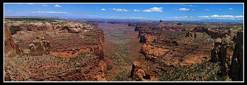
Little Death Hollow and Wolverine canyons are two nice slot canyons that drain into the Escalante River from the lesser known east side. Situated between Capitol Reef National Park and the Escalante River just off of the Burr Trail, these canyons are pretty remote. A loop hike incorporating both of these canyons is 20 miles long and makes for an excellent day hike. There is no technical skills or gear needed to do these canyons.The one very interesting thing is that they are composed of the Wingate Sandstone rock unit instead of the Navajo sandstone. This is actually quite rare because the Wingate sandstone is much more resistant than the Navajo sandstone and it tends to erode into larger "gorge" type landscapes. If you're familiar with southern Utah, the entire Orange Cliffs area west of Canyonlands National Park is all Wingate sandstone. The Flint Trail switchbacks that lead down into the Maze District of Canyonlands National Park takes you down the only break in the Wingate Orange Cliffs large enough to bulldoze out a road. Thats why the Maze District is known as "Under the Ledge" country. These two canyons cut through a group of cliffs known as the Circle Cliffs. Similar to the Orange Cliffs, this is a long series of Wingate cliffs stretching for many miles.
Millard Canyon of the Orange Cliffs that surround the Maze District of Canyonlands. All these large cliffs are the Wingate sandstone.
In contrast, every slot canyon in the Robbers Roost area (San Rafael Desert) is composed of lighter colored the Navajo sandstone rock unit. Next time you are around there, take a look around at the rocks you see. The large flat expanse of wasteland you see when driving on the Hans Flat road is all the reddish-brown, very resistant Carmel Formation. Sitting below the Carmel Formation is the Navajo sandstone. Where the Carmel Formation is completely eroded through, the erosive Navajo formation becomes exposed and deep slots are formed. Often, the initial transition from the Carmel to the Navajo is a large dryfall that would need to be repelled.
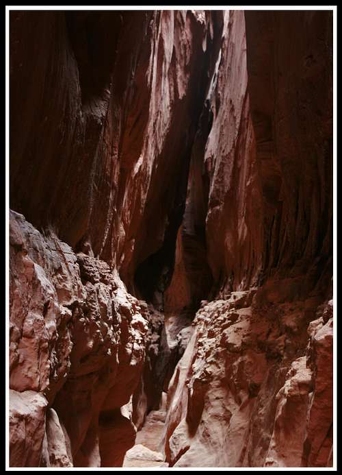
The deep Navajo narrows of Bluejohn Canyon
See the strat column below to gain a reference of the rock layers in southern Utah. These layers shown are in the Permian, Triassic and Jurassic time periods ranging from 65 to 200 million years of age. Next time you're in Utah, try to identify these rock units.
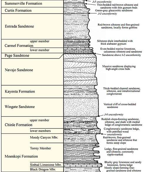
Strat column showing the rock layers in the Escalante National Monument area
Due to the resistance of the Wingate sandstone similar to the Carmel Formation, slots are rare. Thats what makes these two canyons so special. While most canyons you may descent are made of Navajo and have the white or pink color to them, Little Death Hollow and Wolverine Canyons are two slot canyons where the rocks are a red-orange color. The other claim to fame these canyons have is the large amount of petrified wood surrounding the upper end of these canyons. The Wolverine Petrified Natural area has at times ten to twenty foot petrified logs simply lying around at the surface and are quite common. The Chinle formation, sitting stratigraphically one rock unit below the Wingate Sandstone was formed at a time when large swampy forests dominated the landscape. As geologic time progressed, these swampy forests were buried and became petrified. This rock unit was buried under thousands of feet of other rock layers until the Laramide uplift that caused erosion of many overlaying layers and exposing the large petrified logs at the surface. Feel free to explore around but don't take any of the petrified wood. This is the largest collection of petrified wood in the country except for the Petrified Forest in Arizona.
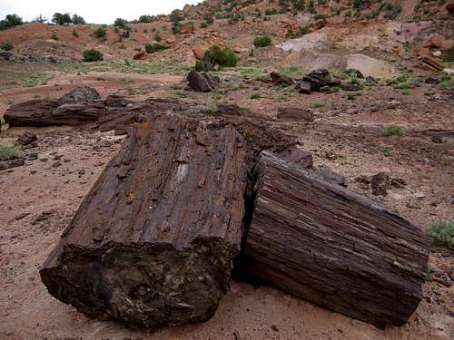
Petrified wood near the trailhead for Little Death Hollow
Getting There
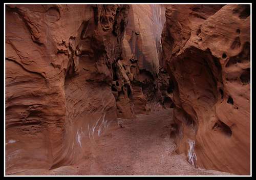
To get to the trailhead for these canyons, drive 19 miles east from Boulder, Utah on the paved (though terribly paved) Burr Trail road. This road is quite possibly one of the most scenic roads in Utah as it strategically weaves its way through the canyons and cliffs between Capitol Reef National Park and Boulder, Utah. After 19 miles, turn right and head south on the unpaved Wolverine Loop Road. Drive south for 12 miles to the Little Death Hollow trailhead. You will pass the trailhead for Wolverine Canyon. At the Little Death Hollow trailhead you will find an old corral and a drinking bucket for cows, as well as room for a few cars. A sign at the trailhead marks it as Little Death Hollow.If you look southwest from the trailhead you will notice a large valley below a series of cliffs on each side. These are part of the Circle Cliffs made of the Wingate sandstone. The "trail" starts heading down this valley in a southwest direction. Continue down the trail and after about 2 miles another wash will come in from the left. Stay right and continue downstream. At places you may get a little wet if there is water in the stream bed, mainly in the early spring or winter months. There is also a series of springs in the stream-beds that provide water in all months. At 4 miles from the trailhead the canyon really starts to narrow up. The really cool thing about Little Death is that the slot is 5 miles long! You will be continually walking in narrows for around two hours. Enjoy every minute of it as this type of slot is rare. The only obstacle you may encounter is a large chalkstone with a large puddle of water on the downstream side. In May 2010 when we did these canyons we had to wade through 2 feet of water to pass this puddle. The clay at the bottom of the water felt weird. The water-clay boundary isn't really there and your foot seems to sink down into a foot of water and a foot of clay!
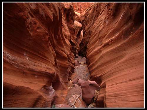
Little Death Hollow Narrows
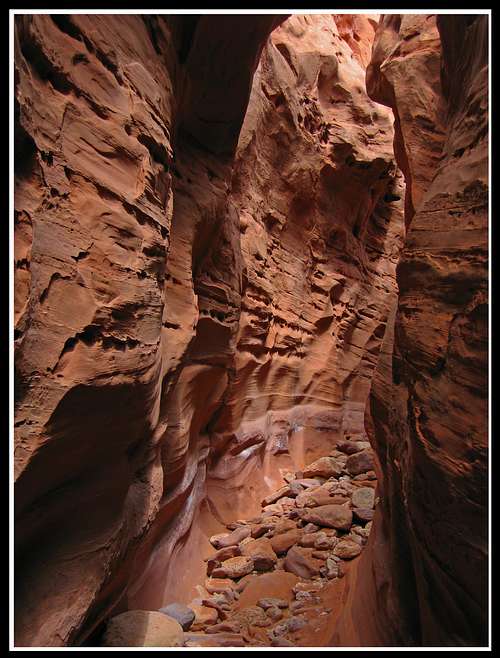 Little Death Hollow Narrows Little Death Hollow Narrows | 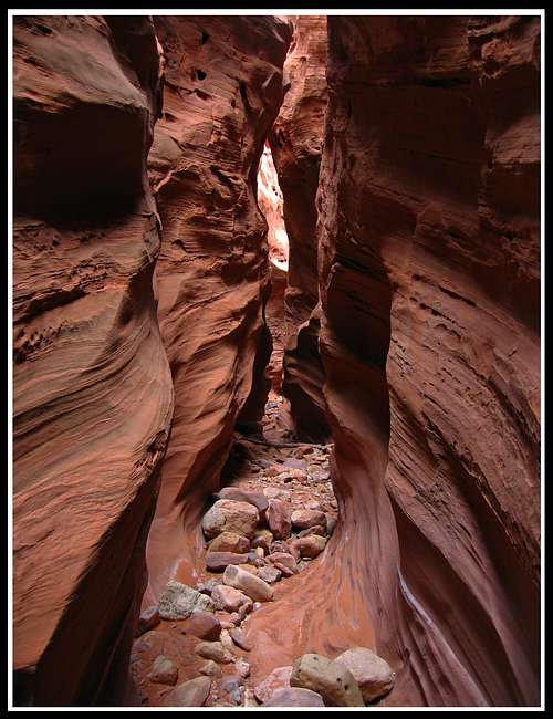 Little Death Hollow Narrows Little Death Hollow Narrows |
At about 9 miles from the trailhead the canyon will open up into a large opening with many trees. This is where Little Death Hollow drains into Horse Canyon. If you were to head left (downstream) along Horse Wash you will hit the Escalante River in about a mile and a half. That is an optional side trip that will add three miles to the loop, maybe worth it if it's hot and you want to do a little swimming. Otherwise, turn right and head upstream in Horse wash. You will probably see an old road that looks like it's still used. Follow this to cut the switchbacks made by the meandering stream. After about 2 miles following this road look for a canyon opening coming in from the right. This is Wolverine Canyon and you should turn right here and enter the second canyon of your loop.
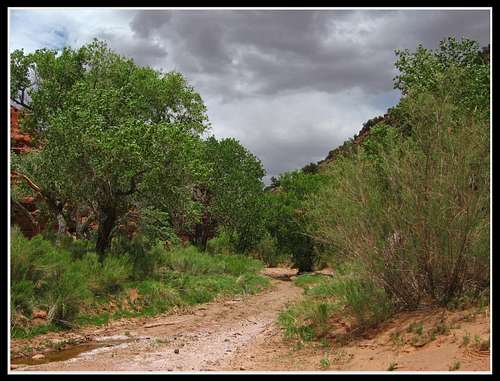
Horse Canyon
Wolverine canyon isn't nearly as exciting or narrow as Little Death Hollow but it makes fro a nice 3 mile walk through some new scenery. The most important routefinding you will do on this loop is making sure you take the right wash after getting to the upper end of Wolverine Canyon. After 3 miles in Wolverine Canyon you will come to a fork in the stream. The left fork takes you to the official Wolverine Canyon Trailhead. Your car isn't there and you will add 2.5 miles of road walking to your already pretty long hike if you head that way. We even saw a hand made rock arrow pointing to the left that was designed for people who parked at the Wolverine Canyon Trailhead. Ignore this large arrow.
Wolverine Canyon
Make the right fork and walk cross country for 2 miles through the wash until you hit another small fork in the stream-beds. Take the right fork once again and walk another mile and a half to the road you came in on. You will have to make you way under an old barbed wire fence probably designed for cows right before you get to the road. Don't try to destroy this fence as it may still be used. I think it marks the boundary between the Grand Staircase Escalante National Monument and BLM lands. Along the way in this wash you will find thousands of petrified wood logs and chunks. This area is really amazing. Petrified wood will be seen all the way until you get back to the road.
To get back to your car, take a right (south) turn on the road and walk the short half mile to the official Little Death Hollow trailhead. If you ALWAYS take right turns on this loop you will be set on the routefinding! This loop can also be done in the other direction or even could be done starting at the Wolverine Canyon trailhead. The way we did the loop is how I described it here.
Red Tape
Even though the official trailhead lies on BLM lands, they don't want you camping AT the trailhead. Upon entering the National Monument they want you to obtain permits to camp.DO NOT take any of the petrified wood you will see.
No fees
Camping
If you have a free permit obtainable at the BLM office in Escalante, you can camp anywhere except for the trailheads.It's recommended you don't camp in washes though.