From the fairy scenery of the Ciucaş Mountains (sculpture-like rock formations) via the grandest canyon of the Eastern Carpathians – the Bicaz gorge (isolated rock towers) – to the limestone cliffs of the Haşmaş Mountains resembling the Piatra Craiului.
(UKRAINE)
From the grassy ridge of the Svydovets (polonynas, primeval beech forest) to the Skhidni Beskydy (the summit of Czeremcha with a border stone dating back to 1934, Stuzhytsia – primeval beech forest – a UNESCO World Heritage Site).
From the historic, strategic Dukla Pass (an unforgettable encounter with Rosalia longicorn) to Spis Castle (a WHS captured at sunset with a panorama of the High Tatras in the background), then to the Zádiel Valley (a spectacular canyon in the Western Carpathians) and the caves of the Slovak karst (World Natural Heritage).
Let’s set out on an enthralling trip through the most extensive mountain unit in Europe and one of the wildest mountainous areas on this old continent…
DAY 1
DAY 1: Sat/Sun 20/21-07-2013
PROSTEJOV – BUDAPEST KELETI – BRASOV (distance covered by train: 1140 km)
BRASOV – SĂCELE (distance covered by bus: 7 km)
SĂCELE – BRĂDET (distance covered by horse-drawn wagon: 5 km)
BRĂDET – BĂBARUNCA (distance covered by car: 10 km)
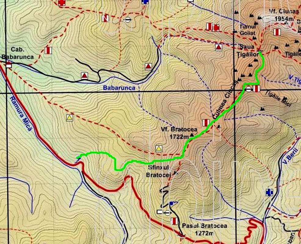
Rest place under Bratocea pass – ŞAUA ȚIGAILOR (distance covered on foot: 18 km, elevation gain: 800 m)
On a night train from Budapest with an Australian traveller looking forward to seeing the legendary Dracula’s castle. Listening to his stories about his incredible Uzbekistan/Tajikistan adventures. In no time the train pulls up at my favourite :-D railway station at Brasov, where I leave my heavy (30 kg) backpack. I walk through the second biggest city in Romania to the coach station in its eastern part, connected with the town of Săcele.
Disappointment: No long-distance buses at all. The first conversations with some locals. I try to hitchhike but without success. A horse drawn wagon! A dream! Two horses, three kids and a man. The youngest baby (no more than 2 years old) sleeps like a log, jolted all the way on an extremely hot summer day. They help me to get as far as Brădet – the last village. I walk along the road for about 3 km. Some Christian missionaries (Adventists) give me directions helping me to get closer to the foothills of the Ciucaş Mts. But to my surprise, they haven’t heard of Bratocea Pass. I take the wrong exit at a rest place. A spring of water at a zigzag. At first, I think this is Bratocea Pass. I notice some red lines on the tree trunks. What a stupid mistake to follow them.
I miss my way. An ascent through broadleaved woodland. A beautiful glade with an abandoned chalet. No marked routes in sight. A traverse of a wooded summit. Navigation becomes precarious. A difficult ascent through evergreen forest dotted with small crags. Dense carpets of bilberries and junipers at timberline. People picking berries. What a relief. Finally, after three hours of trudging along unmarked routes, I find a trail marked with red stripes:-)
Țigaile Mici(Little Țigăi)
I am slowly ascending the Bratocea ridge. A flock of sheep, the shepherds try to drive their dogs out of my way. I began traversing the Țigaile Mici(Little Țigăi). A view of the Gropşoare-Zăganu Ridge, opposite the Bratocea. And the first encounter with Romanian hikers. They just can‘t believe they have met a lone Czech adventurer. Blossoming carpets of lady’s mantle. And the breathtaking scenery, nature’s artwork I haven’t seen before, fashioned into an extremely picturesque association of sculptures, towers and spires named Țigaile Mari(Great Țigăi), basking in the evening sunshine. I decide to pitch my tent at Şaua Țigailor, in the heart of the Ciucaş Mountains. Now it is just the right time for some contemplation, at twilight.
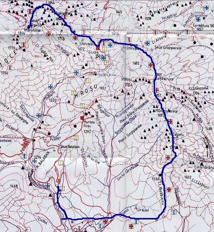
ŞAUA ȚIGAILOR – Vf.CIUCAŞ (1954 m) – BABELE LA SFAT – CABANA CIUCAŞ – GROPŞOARE – TURNUL DE ARAMĂ – ZĂGANU – CHEIA(distance covered on foot: 20 km, elevation gain: 1400 m)
CHEIA – BRASOV (distance covered by car: 40 km)
A windy morning. The sculpture-like Turnul Goliat (Goliath Tower) and limestone cliffs named Királytetö illuminated by the rising sun. I climb the highest peak, Vf. Ciucaş (1954 m). Distant views of Brasov, the Grohotiş Mts., the Buzau, the Piatra Mare and the Bucegi. A steep descent to a fascinating nature‘s sculpture called Babele la Sfat (Matchmakers). Various species of calciphilic flora. Then a careful descent down a kind of little chimney, a traverse of the NE side of Țigaile Mari (Great Țigăi), and a saddle at its foot. A view of its photogenic E side. Horses grazing, a flock of sheep and oxen. Following the red cross trail winding through a patch of wood, I approach the newly restored Ciucaş Hut.
Two young men. An ascent through clumps of junipers, onto the southern ridge of the mountains. A romantic valley encompassed by the Muntele Albiile. A gentle ascent with views of the Bratocea–Ciucaş ridge across the main valley. Shepherds, resting. I ask them if I am right recognizing the Penteleu Mts. (on the SE horizon), the Siriu Mts. (S) and the Vulcani Noroioşi (Mud Volcanos). Two metal shelters on the crest. I climb the summit of Gropşoare to find a historic post on its top, dating back to 1938. Carpathian Bellflower - an endemic species of flora. A steep descent via a craggy section with an exposed wall fixed with cables. Turnul de Aramă (Copper Tower), then a saddle below Vf. Zăganu, next a very steep descent along its cliffs (geological preserve). An expanse of wood with a small glade and a chalet. And, so soon, I have to say good-bye to this wonderful world of conglomerate and limestone cliffs.
Turnul de Aramă, Copper tower
Carpathian Bellflower
Zăganu cliffs
It is time to continue the gentle descent through mixed woodland. Edible mushrooms. THIRST. I hear a stream. At last I find water, after my 30-hour stay in the Ciucaş Mts. I walk along the road connecting Bucharest with Brasov. To my surprise, there are no buses. To thumb a lift? Little chance – big trucks busily carrying their heavy cargo. But I am lucky today. A sedan with two men pulls up and I ask for a ride. We go directly to Brasov, where they drop me off. I walk to the railroad station. I retrieve my heavy backpack, rest and sleep at the station. I get woken by a policeman at midnight.
DAY 3
DAY 3: Tue 23-07-2013
BRASOV – GHEORGHENI (distance covered by train: 150 km)
GHEORGHENI – CHEILE BICAZULUI (distance covered by bus: 30 km)
CHEILE BICAZULUI – CHEILE BICAJELULUI – DRUMUL SURDUCULUI – POIANA VĂRĂRIILOR – ŞAUA ȚIFREA – BELVEDERE – SERPENTINA MICĂ
(distance covered on foot: 15 km, elevation gain: 600 m)
Brasov railway station, 4 a.m. My train to Gheorgheni departs. The first views of the western side of the Hăşmaş Mountains at dawn, several kilometres away. An imposing wall of limestone cliffs. I arrive in Gheorgheni (8 a.m.). This time I leave my heavy backpack at the bus station. I wait until noon for a Sibiu–Piatra Neamt bus. A zigzagging road to Pângăraţi Pass, the busy resort of Lacu Roşu(Red Lake), finally a good decision to get out of the bus at Serpentina Mică(Small Zigzag). I find accommodation: A place in a tiny two-bedded hut – 30 RON/24 hours.
Piatra AltaruluiAltar Rock
Gâtul IaduluiThe Neck of Hell
The first glimpse at Piatra Altarului(Altar Rock a.k.a. Stone of the Shrine) the most magnificent crag of Bicaz Canyon. The old and modern tunnels (155 m long), the Serpentina Mare(Big Zigzag) with 5 zigzags descending 50 metres, the entrance named Poarta Iadului(Gate of Hell) and the vertical walls of the Peretele Bardos. Souvenir-sellers, Bicaz Creek and Turnul Negru(Black Tower). A small waterfall, a zigzag at the foot of the Santinela(Sentinel) rock climbing route, the most attractive section called Gatul Iadului(Hell’s Throat a.k.a. The Neck of Hell) and I am at the end of the craggy part of the 5 km long Bicaz Gorge, considered the grandest canyon in the Eastern Carpathians.
Piatra Surducel
I return to the Podul Ungurilor(The Bridge of the Hungarians), where I get sprinkled by a summer shower. I cross a suspension bridge and leave the Bicaz Gorge. I walk up to a lookout. In the wood, I am lucky to be able to fill my bottle with fresh water. I can see the romantic Căprăria Glade with its lonely houses and a herd of horses. I go on ascending, this time along a wooden fence. The scenery is of rolling green hills with haystacks – what a contrast with the craggy Bicaz Canyon located a stone’s throw from here. A descent to a stream called Bicajel Mic. I look into a a small ravine, cross a wooden bridge, pass by some haystacks with Piatra Surducel in the background and start ascending towards Vărăriilor Glade. At an information panel with interesting information on Cheile Bicazului – Hăşmaş National Park, I switch from the yellow striped trail to a trail marked with yellow triangles, which leads to Țifra Saddle. I spot an unmarked path, “This must be the steep ascent to the first lookout of Piatra Poienii.“ I follow the path and am rewarded with a stunning view of the Muntele Ghilcoş and the isolated crag of Piatra Surducel. A traverse to the second lookout, which offers the long-awaited, awesome eagle view of the heart of the Bicaz Gorge 300 m below my feet. I’m not alone at the lookout – there is a kitten here! What a surprise. While recording a video footage of the zigzagging road down there, I try not to tread on the cute little creature. This turns out to be pretty dangerous. Just a half-metre step aside and I (we) would have been lost… I carry the kitten on my shoulder, to a safer place. A three-toed woodpecker – what a rare catch. A descent to a glade, a nice view of the western face of Piatra Poienii basking in the evening sunshine, then a return to Serpentina Mică(Small Zigzag), where I have booked a chalet, in the very heart of the Bicaz Gorge.
SERPENTINA MICĂ - CANIONUL LAPOŞULUI – ŞAUA CUPAŞ – POARTA DE PIATRA – CHEILE CUPAŞULUI – ŞAUA SUHARD – SUHARDUL MIC – BELVEDERE – LACU ROŞU – VALEA OILOR – POIANA ALBA
(distance covered on foot: 20 km, elevation gain:2 000 m)
A gradual ascent along the red triangle trail. An extremely dry canyon of Lapoş – no waterfalls at all. But I can find water and fill in my bottle in the upper part of the canyon. An ascent to Cupaş Saddle. Scattered, lone houses with grazing cows and a “cowboy“. The land of the Hungarian-speaking Szekler people. A panorama of a grassy ridge named Piciorul Ciurgaului. A gentle descent through a meadow, following red dots, then a steeper descent through mixed forest. I am back at Serpentina Mică.
The land of the Szekler people
I continue along the road via Poarta de Piatra(Stone Gate), then after about 1 km I turn right, taking the blue dot trail via Cupaş Gorge. A local guy advises me to refill my water bottle. Slowly gaining elevation, I walk up through spruce woodland, following yellow stripes. At Suhard Saddle (with a haystack), I take a left turning and follow blue triangles leading to another pass. A black woodpecker – another rare catch:-) At the top of Suhardul Mic, offering a spectacular panorama of the Red Lake resort encompassed by the northern ridge of the Hăşmaş Mts. (Licaş – Ciofronca – Haghimaşul Negru), I meet some Hungarian tourists.
Panorama of the northern part of the Hăşmaş Mts. with Red lake
I head for another lookout, on the top of Grădina Zânelor(Fairy Garden). I admire the magnificent views of the entire Bicaz Canyon with all its major rock formations including the most spectacular solitary crag named Piatra Altarului, the Ceahlău Mountains on the horizon.
Stitched panorama of the Bicaz Canyon
Then I seem to be missing my way, which is confirmed by a talk with Hungarian hikers. I had taken the wrong (unmarked) path. I have to bushwhack a bit. Finally, I find the blue triangle trail descending along the foot of Little Suhard to the resort of Red Lake. I take the red cross trail to Balconul de Piatra(Stone Balcony) – the most popular “belvedere“ on the shore of Lacu Roşu - the largest naturally dammed reservoir in Romania. Boats but also the tips of the broken trunks of spruce trees projecting above the surface of the lake, Piatra Ghilcoş reflecting in the waters of its namesake, a close-up of dragonflies. I cross a wooden bridge to get to the opposite shore of the lake, where there is a superb vantage point named Poarta de Piatra(Stone Gate), which affords the best view of the lake and the dominant limestone crag of Suhardul Mic reflecting in it...
Fairy scenery
I follow the blue striped trail running via the Sheep Valley. To my surprise, I see cows but no sheep:-) I walk up a sloping pasture and approach evergreen woodland. I traverse Piatra Potcoavei(Horseshoe Stone) and reach Poiana Alba(White Glade). Horses and cows grazing, busy chalets. While looking for the most convenient place to camp, I stumble upon a brand new refuge with a source of drinking water – what luck!
POIANA ALBA – HĂGHIMAŞUL NEGRU (return) POIANA ALBA – HĂGHIMAŞUL MARE – PIATRA SINGURATICĂ – BĂLAN
(distance covered on foot: 15 km, elevation gain:1 600 m)
Early in the morning, I start to ascend the rocky pyramid of Hăghimaşul Negru. Views of the entire Poiana Alba(White Glade) including Küpö, a reservoir that has dried up and Hăghimaşul Mare. Droppings of chamois on the path. As there is no marked trail, I have to bushwhack through pristine spruce forest. A return to the wooden refuge. Poiana Alba – a romantic picnic in the meadow. By the fireplace, a shepherd whose native language is Hungarian, tells me how the mountain refuge was constructed about 2-3 years ago. I walk to a place where a pond was. Now the place (probably called Küpö) is completely dry, in stark contrast to a photo shown on the back of my map, where Black Hăşmaş reflects in the bygone waters. The times they’re a-changin’ …What a pity! A group of Hungarian hikers. I walk to the signpost, which reads ‘Fehér-mezö.’ A herd of horses. Without a shadow of a doubt, Poiana Alba ranks among the largest Carpathian “poianas“ (i.e. glades) I have ever roamed.
Poiana Alba, White glade
Hăghimaşul Negru
I gradually gain elevation, heading for the saddle named Bárány-nyak. Confusion: I’m having difficulty finding an unmarked path to the top of Great Hasmas. Two pairs of Hungarian hikers coming from the opposite direction say: “We didn’t see any path forking to the top.“ So I decide to get to the summit via sheep tracks. I successfully reach the lower summit, which I consider the highest one. The first view of Egyes-kö to the southeast. Hungarian hikers from Miercurea Ciuc. I volunteer to take a photo of them on the summit. Only now do I notice a huge group of people 200 m away and I realize that must be the highest point of the Hăşmaş Mts. I have to bushwhack a bit to the signpost on a wooden trig point: Hăghimaşul Mare, NagyHagymás csúcs (1792m). Eastern views of Poiana Alba, Hăghimaşul Negru and Suhardul Mic with the Ceahlău Mts. in the background. I walk to the iron cross 100 m off the top so as to have westerly views of the Giurgeu Mts.
Great Hasmas projects only 50 m above timberline. The funny thing about the mountain is the fact that its eastern side, completely wooded, slopes gently, which contrasts sharply with its western, craggy face dropping abruptly towards the valley of the Olt River, thus forming a massive 2 km long limestone wall named Bárány-havas.
Bárány-havasGreat Hasmas
Another Hungarian family on my way.I gradualy lose elevation and go on along the edge of the craggy face. My dream of stumbling upon grazing chamois comes true. A great catch! I have to wait a bit to capture the rocky outcrops illuminated by the sun. Strong gusts of wind. A steeper descent along an unmarked trail winding through a patch of forest. I run into the group of Hungarian hikers from Sfântu Gheorghe that I met yesterday. A traverse of a woody section transitions to a plateau used as a pasture. Another cross on the edge of Bárány-havas. I descend to Şaua Curmătura and marvel at the karst scenery with the commanding towers of Piatra Singuratică(Solitary Rock). I have no doubt that this photogenic, monumental rock cathedral deserves to be captured from various angles. The most impressive view is offered by a spot located about 100 m from the namesake hut. I decide to record the scenery of clouds being driven by the wind over this picturesque cluster of limestone towers and needles.
Solitary Rock
There are, too, gorgeous views of the southwestern, craggy face of Hăghimaşul Mare to the left, while looking to the right I can admire Moara Dracului(Devil’s Mill), a huge rockslide on the west side of the Ecem Massif. I capture all the three great crags (Devil’s Mill, Solitary Rock, Great Hasmas), which resemble the cliffs of the Piatra Craiului, so that after coming back home I can stitch the pictures together.
Hăşmaş massif
I talk to my new, adventurous Hungarian acquaintances. They come from Gheorgheni and are heading, via Great Hasmas, to Red Lake. Then I descend through spruce wood, down a rather steep red triangle trail. I refill my bottle with water. At the upper end of Bălan village I photograph Hăghimaşul Mare, in accordance with my plan. I pitch my tent in the vicinity of this very special “lookout“.
DAY 6
DAY 6: Fri 26-07-2013
(ROMANIA)
BĂLAN – SÂNDOMINIC (distance covered by bus: 10 km)
IZVORU OLTULUI – GHEORGHENI – DEDA - SARAȚEL - BISTRIȚA (distance covered by train: 166 km)
BISTRIȚA – NĂSĂUD (distance covered by bus: 24 km)
NĂSĂUD - SALVA (distance covered by train: 6 km)
I get woken by the locals who are sharpening their scythes with whetstones, preparing to mow the morning grass. One of them approaches my tent and receives a nut müsli bar. He is thankful:-) I look for a spring and find one. Then I try to hitchhike but without success. I go to the coach station in Bălan, where I listen to a driver who has worked in the Czech Republic. I get on a bus departing at 8 a.m., heading for Sândominic. I have to get to the railway station at Izvoru Oltului, where I take a train to Gheorgheni. On the train, I try to film Great Hasmas from the window and say good-bye to the Hăşmaş Mountains.
When I travel through the Carpathian countries, I normally prefer the railroad. I feel that one can sense their spirit when admiring their diverse landscapes from the window of a train. The old-fashioned log-cabins scattered in the meadows, the typical scent of the omnipresent haystacks. The first tunnel. The train dispatcher at the station in Izvoru Mureşului. Beech woodland variegated with spruce forest, rock outcrops revealing the geological history, fairy pine groves...
Video TR - Day 6
I have a conversation with a young man travelling with his mother from Bucharest to Topliţa. They advise me to capture Lazar Castle and Ditrău Church as well. What a medieval atmosphere. The valley of the great Mureş River. The Mureş Defile Landscape Reserve (Reservaţia peisagistică Defileul Mureşului) with its “disintegration caves“ (tree trunks deposited in volcanic sediments have rotted away resulting in tubular caves), unique in Europe. The natural meanders of the Mureş River – no man-made barriers. A white stork flying. A romantic valley surrounded by the foothils of the Călimani Mts., stretching to the north, and the Gurghiu Mts. to the south. Wooded hills with rocky outcrops of volcanic origin, another tunnel, holiday-makers having a picnic.
I change trains at Deda. On the train to Bistriţa, I try to capture the scenery of rolling hills variegated with a special kind of landscape resembling the deserted Hungarian plains (pusta). (Unfortunately, I have only recently learnt about a place named “Vulcani noroioşi de la Monor – La Gloduri“ – it must be a great attraction, just 2 km away from Gledin’s train station, situated directly on the railroad connecting Deda with Bistriţa). Two tunnels. A beech forest with a campsite 2 km off Saraţel – probably (Masivul de sare de la Saraţel). What a nice, sunny afternoon! And just a dozen km away – a heavy downpour at Bistriţa. I take a bus to nearby Năsăud. There is a fine view of the Rodnei Mts. from Dumitra Pass. To my surprise, no connection to Sighetu Marmaţiei in the evening…
DAY 7
DAY 7: Sat 27-07-2013
(ROMANIA)
SALVA – SIGHETU MARMAȚIEI (distance covered by train: 118 km)
SIGHETU MARMAȚIEI – border crossing point – SOLOTVINO (distance covered on foot: 3 km)
(UKRAINE)
SOLOTVINO – YASINYA (distance covered by bus: 80 km)
YASINYA - STRUKIVSKA TSERKVA – DRAHOBRAT – IVOR lake
(distance covered on foot: 15 km, elevation gain: 1 000m)
I wake up spontaneously at 2 a.m. I find a path to Salva railroad station, where I get on a fast train from Bucharest. I arrive at Sighetu Marmaţiei early in the morning. I have to wait a bit until they open the RO/UA border crossing point.
I cross the bridge over the Tysa River. I undertake the “obligatory“ procedure of checking my backpack at the UA point named Solotvino. I try to leave my heavy backpack at the railroad station but without success. Fortunately, a man, who looks like a Romanian, helps me by locking my pack in his garage. I take a marshrut (i.e. minibus) heading for Ivano-Frankivsk. Beautiful Ukrainian ladies. A woman travelling from Odessa gazes at my brand new map of the Marmarosh Mts. The valley of the Tisa River. We pass by the “Centre of Europe“ near the village of Dilove. A half-hour pause at Rakhiv – the capital of Hutsulschyna. Finally I arrive at Yasinya.
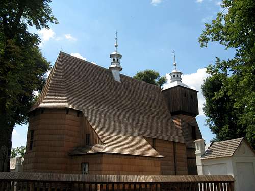
I get out of the minibus and pass by the Edelweiss Guesthouse. I visit the tserkva (wooden church) located at the upper end of the village, then return to the centre of this important Transcarpathian resort. I follow a trail marked with green stripes and cross the bridge over the Black Tysa River. Fortunately, a group of Slovak people led by an Ukrainian priest invite me into the brand new World Heritage Site called Tserkva of Our Lord’s Ascension (Strukivska tserkva), which is part of UNESCO’s transnational property named “Wooden Tserkvas of the Carpathian region in Poland and Ukraine“. This is one of the best preserved tserkvas of the Hutsul type made of spruce timber. Built in 1824. The Slovaks left the batteries for their camera in the charger at Tyachevo. I offer to use their SD card in my camera. After leaving the wooden church, I meet three Czech hikers. I encourage them to visit the church (I hope they succeded in having a look at its valuable interior).
Yasinya - Tserkva of Our Lord's Ascension
I search for the green stripes and walk on, among haystacks, gaining elevation in the sultry sun. Thirst. I have to ask for drinking water at a lone house. The kind locals fill my bottle with cold, refreshing water. Thanksgiving. I go on gaining elevation, heading to the saddle near Svydovetska Bukovinka. A traverse (very old marking). A view back to Petros and Hoverla, the highest summit of Ukraine. I pass by deserted log-cabins and go on via beech woodland. I try to help a bumblebee to get out of a puddle. It flies up right away – what a pleasure. I enter the territory of the Carpathian Biosphere Reserve and observe a pair of Bullfinch. I follow a neverending switchback and reach the resort of Drahobrat, recalling my 2007 visit. The tiny tarn is packed with people and tents, and clumps of berries. I am able to (re)find the popular unmarked path and carry on ascending the most romantic place in the Svydovets: a tarn called Ivor located at the foot of the mountains‘ highest summit – Blyznytsia.
IVOR lake - PEREMYCHKA pass – URDA – valley of KISVA river – KPP LAZESCHI
(distance covered on foot: 15 km)
A romantic morning in the heart of the Svydovets Massif. I take photos of Blyznytsa, its cliffs named Gendarmes and the tarn named Ivor.
The heart of the Svydovets massif
The shepherd dog is having a bath. Gusts of wind. When packing my tent I make a stupid mistake which results in its flying 200 m away. On my way back to the resort of Drahobrat, I pass by a barefooted man from Ivano-Frankivsk (he used to live in Prague), who wishes me: „Šťastnou cestu“. I pick berries when ascending the grassy slope. Peremychka Pass – signboards, strong wind and two crazy motorcyclists approaching from Drahobrat and heading towards Blyznytsa along the main ridge. What a shame!
I decide to lose elevation and go on via an unmarked path to the other, wilder face of the Svydovets Massif. Solitude, tranquillity, and the picturesque scenery with a mountain creek full of clean, clear water. I observe some birds of prey and a viper basking in the sun, right on the trail. Another precious catch. A shepherd’s hut on Polonyna Urda with a flock of sheep, resting lazily.
Valley of Kisva river
I head to a patch of primeval beech forest which is a part of UNESCO World Heritage. I descend towards the Kisva River and find a sign that reads: “KPP Lazeschi – 7 km“. I try to capture the scenery of first-class Carpathian wilderness, admiring a double-trunk beech tree and an uprooted tree trunk lying in a ravine as well. I follow an unmarked path which dissapears in the river. No bridge in sight. I cross the river (several meters wide here, in its upper section). Once, twice, three-times… A Purple Emperor attracted by my jacket. A spring of mineral water. I read another sign announcing the name of the chief ranger. Lying tree trunk occupied by a wood destructive fungi. A thunderstorm. I must move faster via this endless valley. Rain, lightning. I have to take multiple crossings of the rushing river (more than a dozen meters wide in its middle section). Finally, the last one. I am soaked to the skin. A dirt road and a tollgate. I cross the first wooden bridge leading to the checkpoint (KPP Lazeschi) of the Carpathian Biosphere Reserve. Fortunately, the office is open and I am welcome. The staff invite me to stay overnight. I jump at the chance and dry my wet gear by a tile stove. I get a hot meal (mushrooms) and tea. And I’ll have my camera batteries recharged. What comfortable accommodation for only 35 HR (3EUR)/20 hours.
KPP LAZESCHI - KOSIVS‘KA POLYANA
(distance covered by car: 20 km)
KOSIVS‘KA POLYANA - LUH
(distance covered on foot: 6 km)
LUH – SOLOTVINO – TYACHIV
(distance covered by bus: 43 km)
A sunny morning at the log cabin belonging to KPP Lazeschi (a checkpoint of the Carpathian Biosphere Reserve). A spring of mineral water, contemplation, spiritual stuff. Huge mushroom brought to me by a ranger. I take a shot of an amazing aureole at the edge of Kisva pristine woodland. I have to wait for the promised transport (down a 20 km long valley of the Kisva River). In the afternoon two men arrive in a car. One of them asks, “Odkud jsi?“ (Where are you from?). At first I think he is a Czech, but he turns out to be a Ukrainian studying and living in Prague. He comes back to his homeland for holidays. The guys help me a lot as there is hardly anybody who can drive a car to such a distant location. (I am told that the rangers usually ride a motorcycle.) After the first hundred meters of our journey (max.15 km/h), I understand why…
Aureole
A dirt forest road full of rocks, cracks and troughs makes the car jolt unrelentingly. (On the most dangerous section I thought the car just must turn upside down.) I bet the usual EU/US driver would not be keen to put his car in jeopardy like this…We stop to taste ferrous water from a mineral spring. Then we pass by multiple glades to arrive at another spring. Young people are swimming in the Kisva River. We pass the first, lone houses after an hour of this tedious journey. A tarmac road, time to say goodbye and thanks. I part with the 40 km long valley of the Kisva River and walk along the road leading from Kosivs‘ka Polyana to Luh. I shake hands with a very old local man who may remember living in the first Czechoslovak Republic established after World War I. A marshrut to Solotvino. I retrieve my heavy backpack and come back to the bus stop, where I take another minibus, to Tyachevo.
Video TR - Svydovets Massif
DAY 10
DAY 10: 30-07-2013
TRANSCARPATHIA
TYACHIV - UZHHOROD
(distance covered by bus: 138 km)
UZHHOROD - STAVNE
(distance covered by train: 67 km)
STAVNE - BAHNA
(distance covered on foot: 7 km, elevation gain: 500m)
I take a midnight bus going from Chernivtsi to Tyachevo. I arrive at Uzhhorod at 4 a.m. and walk to the nearby railroad station, where I can leave my heavy backpack - 14 HR/24 hours. On second thought, I decide to leave it somewhere on the territory of Uzhanskyi NP. Soon I’m on a passenger train (with wooden seats) heading to Stavne. I am still unsure what to do with my backpack. I ask if I could leave it at the station or nearby pub, but without success. I stumble upon a woman who is a widow. I listen carefully to her life-story. And I jump at the chance to leave my backpack at her home. After our two-hour-long conversation, I follow a trail marked with blue stripes. I cross a bridge over the Uzh River and head towards a wooden shelter. A walk up through beech woodland, then a traverse with an endlessly winding path. I get tired owing to a sleepless night. I am thirsty too. I follow a forest road and go on gaining elevation. I get to a glade full of berries. And an empty log cabin used by the border police….
I stay overnight inside a log cabin and sleep on hay. The next morning I follow the red stripe trail, ascending steadily via tiny glades with berries. I reach the UA/PL border at the summit of Czeremkha. There is a historic border stone dating from 1934 on its top. I stare at the damaged fence. Its rusty barbed wire serves as a reminder of the communist era. What is now Ukraine used to belong to the Soviet Union... And the distinct trenches, remembering the world wars. I search for the military cemetary – maybe it is obscured by the clumps of bushes and overgrown by berries. What a dramatic history…
Video TR - Skhidni Beskydy
Now I find this place peaceful and quiet, affording a spectacular view of my beloved Bieszczady Mts. I’ve never seen them before from this angle. I take precious shots of Tarnica, Szeroki Wierch, Halicz, Rozsypaniec and Kinczyk Bukowski. My thoughts are backed by the so called association memory (memories associated with a given place) and I am able to recollect my first Carpathian adventure, which took place 10 years ago in this very special nook often called the Polish Wild East. I try to capture the lesser spotted eagle soaring over me and the deer crossing the glade as well.This land has been rewilded and now it can be proudly called “The Wolf Mountains…“ (I can confirm that with my memory of an encounter with wolves in 2010).
The Wolf Mountains
After a three-hour stay on Czeremkha, I descend through the easternmost patch of Stuzhytsia primeval beech forest – a UNESCO World Heritage Site. I bushwhack along a narrow corridor among uprooted beech trees. A view back to the green canopy of this pristine woodland stretching along the UA/PL/SK border. When looking in the opposite direction I try to capture the picturesque scenery of rolling, forest-clad hills dotted with a mosaic of meadows and lonely houses – the characteristic landscape of the lower parts of the Skhidni Beskydy.
Stuzhytsia pristine woodland
An urgent need to refill my bottle with water. I have to bushwhack a bit. There used to be a springlet, but in the summer it has run completely dry. Frustration. In addition, I lose my way in the dense thicket of bushes. I decide to slowly gain elevation so as to reach the nearest glade, for better navigation. Now I have to walk down the grassed-over slope, into the valley. I hear the rustle of a brook and find it. A long-awaited relief...
I come back to Stavne and get back my heavy backpack. I catch a minibus to Uzhok village. I am keen to visit its wooden church (Tserkva of the Synaxis of the Archangel Michael) – a recent WHS and a part of transnational property named Wooden Tserkvas of the Carpathian Region in Poland and Ukraine. A local guy shows up and unlocks the door, letting me inside the church, which boasts a valuable 18th-century iconostasis. I say good-bye to one of the best known churches of the Boyko type in the Transcarpathian region.
Uzhok - Tserkva of the Synaxis of the Archangel Michael
I underpass 170m long viaduct (it used to be the longest of its kind in former Czechoslovak Republic) and go to Uzhok train stop. I talk to a railroad man. This section nicknamed the „Transcarpathian Semmering“ with plenty of tunnels and viaducts ranks among the most attractive railroads in the Carpathians. Moreover, it winds through a strictly protected zone (not in terms of nature protection): UA (forbidden zone) /EU‘s boundary. Passing by 39m tall Scherbyn viaduct, I try to film both the beautifully-lit patches of woodland in the Uzhanskyi NP and the strategic Uzhocka pass (NB In 2011, I was told by the UA border police that filming of their border zone is still forbidden). I get out of the train at Syanky. I meet an old man with two women heading to Lviv. Their home-made cheese and vegetables are a very welcome enrichment of my monotonous diet. In return, I can offer a summary of my Carpathian adventures so far and plans for the next days. When resting at Syanky train station, we stare at a bat flying inside the building.
Uzhok viadukt
DAY 12
DAY 12: 01-08-2013
UKRAINE
SYANKY - SAMBIR
(distance covered by train: 90 km)
SAMBIR - DROHOBYCH (return)
(distance covered by buses: 2x33 km)
SAMBIR - KHYRIV
(distance covered by bus: 35 km)
KHYRIV - SMILNITSA
(distance covered by bus: 10 km)
SMILNITSA - border crossing point – KROŚCIENKO
(distance covered on foot: 1 km)
POLAND
KROŚCIENKO – USTRZYKI DOLNE
(distance covered by car: 13 km)
USTRZYKI DOLNE - ZAGÓRZ – RZEPEDŹ
(distance covered by buses: 57 km)
RZEPEDŹ - TURZAŃSK
(distance covered on foot: 2 km)
Midnight. I get woken by an old man: “Schnell, schnell,“ he shouts. I am encouraged to board the train as quickly as possible, because its doors close in a couple of minutes. I take his advice although the train is due to depart at 3 a.m. I try to fall asleep while the train shifts forwards and backwards. A train ticket is incredibly cheap: 11HR/90 km (about 1EUR). Moreover, it can be bought from a conductor – no fine, no extra fee at all. I find this practice (in sharp contrast with the EU railroads) very convenient.
Dawn. I get off the train at Sambir and catch a minibus (“marshrut“) to Drohobych. The marshruts stop wherever you want – the local people normally get in/out as close to their homes as possible. Although there are timetables, if somebody is late the driver can wait a bit. The marshrut is usually packed with passengers, sitting and standing. And the quality of roads is sometimes horrible.
7 a.m. Arrival at Drohobych – one of the oldest towns in Ukraine. According to a local guy, it is not necessary for me to take a city bus, because the wooden church I am heading for is located a stone’s throw from the bus station. But soon I learn that it isn’t that simple. There are at least 8 churches in Drohobych (before the 2nd World War inhabited – as most towns in the area – mainly by Poles and Jews). Finally, after multiple “ask abouts“ and more than an hour‘s walk through the city, I find the Tserkva of Saint George, with a bellfry. This new World Heritage Site is inscribed on the UNESCO list as part of the transnational property named “Wooden Tserkvas of the Carpathian Region in Poland and Ukraine“. At present it is being conserved – what a pity.
Tserkva of Saint George in Drohobych
A roundabout way back to the bus station. One of the dispatchers says, “Take my advice and get on a bus heading towards Khyriv.“ I wait till 9:20 a.m. but there is no such connection. The dispatcher appologizes, “ I am sorry, take a bus to Sambir…“ A similar thing happens at the station in Sambir. I hear, “The next bus to Smylnytsia is due to depart at 10:25 a.m.“ I am thirsty so I go out and buy a quarter of a water melon. When I am back, the bus is gone. I take another bus, which jolts along the road to Khyriv. In Khyriv the dispatcher says: “You have to wait at least three hours for the next bus to Smilnitsa.“ Endless waiting in such a “dead-end town“... Moreover, the marshrut is delayed. But in the end I arrive at Smilnitsa (the last UA village on my itinerary) late in the afternoon. The border police officer says: “Crossing the border on foot is forbiden! You must take a couch.“ I try to hitchhike but without success. The second border guy says: “You are permitted to walk about 800 m to the turnpike.“ The third officer checks my passport. And the fourth arranges transport for me. In a car driven by a Ukrainian, I say good-bye to Ukraine…
We arrive at Krościenko – the Polish border crossing point (and a frontier post of the EU). To my amazement, the “obligatory procedure“ takes just a few minutes and our luggage is left untouched. Just a couple of questions asked out of curiosity… My driver drops me off in Ustrzyki Dolne. Thanks to an hour‘s difference between EET (5 p.m.) and CET (4 p.m.), I catch a bus to Zagórz. Here I change buses, and head to Rzepedź. I help an old woman to load her heavy luggage and in return I‘m advised to get out of the bus at the second stop in Rzepedź. I cross the bridge and turn left. A trio of white storks in their nest. A half-hour walk along the road and finally I stand in front of the Tserkva of Saint Michael the Archangel in Turzańsk. I try to capture this new World Heritage Site (part of Wooden Tserkvas of the Carpathian Region in Poland and Ukraine) when basking in the evening sunshine…
Tserkva of Saint Michael the Archangel in Turzańsk
DAY 13
DAY 13: 02-08-2013
POLAND
TURZAŃSK - RZEPEDŹ
(distance covered on foot: 2 km)
RZEPEDŹ - ZAGÓRZ – BLIZNE
(distance covered by buses: 61 km)
BLIZNE - BRZOZÓW - HACZÓW
(distance covered by buses: 26 km)
HACZÓW - KROSNO - BARWINEK
(distance covered by buses: 51 km)
BARWINEK - DUKLA pass
(distance covered on foot: 2 km)
I get up at 5 a.m. in order to take an early morning shot of the wooden church at Turzańsk. Half an hours‘ walk and I come back to Rzepedź bus stop. I try to capture aforementioned trio of white storks in their nest and a nutcracker sitting on the top of spruce tree as well. Unfortunatelly, the bus is delayed considerably due to roadworks. I have to wait almost 2 hours at Zagórz bus station. 10:30 a.m. – the bus to Rzeszów. The friendly driver tells me where I should get off.
The Wooden Church of All Saints in Blizne. A fair-haired guide is waiting in front of this World Cultural Heritage Site – a part of UNESCO‘s Wooden Churches of Southern Little Poland. I am invited into the interior, which enchants me with its folk art decor and the organ gallery. It is one of the finest and most valuable structures of medieval wooden sacral architecture in Poland.
The Wooden Church of All Saints in Blizne
A pair of Polish bikers listens to the guide’s interpretation of the history of the church. Finally, I am allowed to film the picture tale of the gradual “revelation“ of the miraculous figure of Saint Mary Full of Grace, which is placed in the side altar. I ask the guide: “How do I get to the wooden church in Haczów?“ The Polish bikers show me the location of this site on their paper map of the Dynów hills. They advise me to take a bus to Brzozów (due to depart in a couple of minutes, the guide says). At Brzozów, I have to change the bus for a “marshrut“, or rather Jacek’s minibus.
Video TR
I get off the bus in Haczów. A few minutes‘ walk and I stand in front of the oldest wooden church in Poland, built in 1388. This piece of World Cultural Heritage (together with other wooden churches in this region) is also inscribed on the UNESCO’s list as part of the Wooden Churches of Southern Little Poland. I enter the Church of the Ascension of the Blessed Virgin Mary. There is nobody inside. “What an unforgettable experience to be completely alone in this (AFAIK) largest gothic wooden temple in Europe“ – I write in a guestbook and contribute 2 zloties as entry fee.
Haczów - Church of the Ascension of the Blessed Virgin Mary
I come back to the bus stop. A blondie, who has been living for 8 years in the UK and is on holiday in her homeland, advises me to go to Krosno town (instead of Iskrzynia village, according to plan). In Krosno, the dispatcher says that there is a connection towards the PL/SK border at 3:30 p.m. I change buses, pass by two road accidents and get off in Barwinek – the last Polish settlement before the border. I walk up to Dukla pass on the PL/SK borderline. I have a conversation with some Slovak tourists waiting for a bus. They can‘t believe my (RO/UA/PL) Carpathian adventures. Their bus arrives. A lone trekker from Povážská Bystrica (works in England) gets out. He is planning to follow the “prominent“ red stripe trail (Route of the Slovak National Uprising Heroes). We take a photo of ourselves in front of a sculpture and wish a lot of adventures to each other. (He intends to hike as far as the Low Tatras). I decide to pitch my tent on the edge of a meadow. Hay and a white stork, half a kilometre from Dukla pass…
DUKLA MEMORIAL – OUTLOOK TOWER – KYCHERA – KOMARNIK FIR – JARUHY
(distance covered on foot: 15 km)
I have a look at the memorial (monument) situated half a kilometre away from Dukla pass. It is dedicated to the Czechoslovak corps – a participant of the Carpathian-Dukla operation which took place in 1944. There is a colonnade of 15 busts of the main World War II heroes, featuring marshal Konev and general Svoboda. I pass by the bronze boards and read a few names of the killed soldiers. I head towards the 28m tall pylon with the statue of a Russian hero being thanked by a mother. I climb to the top of the 50m tall outlook-tower (entry fee: 1 EUR). There are spectacular views of both PL and SK parts of this strategic site. I listen to the guide and stare at a military exhibition, showing the Carpathian-Dukla operation in photography. I become enthused by historic shots of a Romanian country woman offering milk to a Russian soldier and of the destroyed tunnel at Łupków pass. I go downstairs (200 steps), read an interesting info about reconstruction of nowadays observatory tower and ask the guard if I can recharge my camera batteries.
Dukla memorial
I follow the red stripe trail winding along the PL/SK boundary as far as the border stone No. 147/4. I leave the waymarked route and descend through beech-fir woodland. I take the forest road leading to Komarnik fir preserve. An extremely hot afternoon. Sweat on my brows. I need a rest. I take off my heavy backpack and put it on beech logs.
His majesty Rosalia longicorn
All of a sudden, I notice a flying beetle. Incredible. His majesty Rosalia Longicorn. I get excited and tense. Will I manage to capture this extraordinary encounter? I switch on my camcorder as quickly as possible, trying to film the “phantom“ which landed on a beech log. I scream loudly, like a child. Rosalia alpina responses and takes off. Fortunately, it lands almost immediately and creeps to and fro. This is a very difficult task for me to film it, but I try to do my best and improve my camerawork. And I succeed. Moreover, I am able to spot the bug’s “friend“. They approach each other and have a short fight. What a curious spectacle. To my surprise, I am able to film this rare event. Then I notice another Rosalia sitting on a leaf. “Thanks a million…“ (to the Carpathian Dragon). I’ve been waiting for this encounter for almost 5 years. I rank the Alpine Longicorn beetle among the TOP 10 of the must-see creatures hiding in the Carpathian wildland.
Video TR
The Jersey Tiger with its camouflage. I have to refill my water bottle at Jaruhy crossroads. I cross a creek on the edge of a romantic glade. A hunting (deer) hide. I can’t resist pitching my tent here. I creep out of the hide and hear something rustle. I see droppings of a small rodent. It is hiding inside the wooden construction. From time to time, it puts out its long tail. It seems to be the Forest dormouse. I sit inside the shed and wait patiently for three hours, hoping to film this circumspect creature, but without success. Meanwhile, I observe and video both a roe deer crossing the glade and a wild pigeon. I realize that these hidden nooks of the Laborec hills (not protected) shelter precious habitats contributing to the Carpathian wildland…
KRAJNÁ POĽANA – SVIDNÍK – PREŠOV – SPIŠSKÉ PODHRADIE
(distance covered by bus: 110 km)
SPIŠSKÉ PODHRADIE – SPIŠSKÝ HRAD
(distance covered on foot: 2 km)
I get up at 4:30 a.m. and climb up the ladder to get into the hide. I wonder if I will succeed in observing that peculiar (aforementioned) rodent. Dawn. A morning illumination of Salašiská glade encompassed by patches of broadleaved woodland. A glimpse of the black woodpecker with its typical song. What a precious catch. I fill my two two-litre bottles with water. Then I pack my tent and start to walk up through the forest, following the yellow stripe trail. I cross another glade which affords nice views of the Laborec Hills.
Príkra - wooden church dating back to 1777
I begin descending to the village of Príkra, which boasts another wooden church dating back to 1777. I stare at the map featuring the wooden churches on both sides of the border between Slovakia and Poland. I continue along the “Carpathian Temples Trail“ to Bodružal, which is famed for the Wooden Tserkva of St. Nicholas – a UNESCO WHS inscribed on the list as part of the “Wooden Churches of the Slovak part of the Carpathian Mountainous Area“. It belongs in the oldest and best preserved wooden churches in Slovakia. I try to photograph this “treasure of the world“ from various angles.
Bodružal - Wooden Tserkva of St. Nicholas
I meet a pair of German holiday-makers. I walk along the road to Krajná Poľana. A Russian sedan arrives. A couple from St.Petersburg. They will give me a lift. They are heading to Bulgaria (the Black Sea). The man has a big ipad. He takes a shot of me and his wife. I part with them wishing them “Щасливой дороги.“
Then I have a conversation with a local gypsy. Good news: He says there is a bus connection to Svidník at 2:20 p.m. White storks in their nest in Ladomírová. I change buses in Svidník and Prešov as well. I get on a bus going to Tatranská Lomnica. Zigzags at Branisko. I get off the bus at Spišské Podhradie and follow the trail marked with yellow stripes. I pass by the railroad station and climb a low stone wall by the sidewalk. It affords a fine view of Spiš Castle basking in the evening sunshine. Souvenir-sellers. I take their advice and climb the opposite hill. What a superb vantage point. I pitch my tent and admire a wonderful panorama of the High Tatras and the silhouette of the castle with the setting sun in the background. Kind of magic…
SPIŠ CASTLE – DREVENÍK – SPIŠ CAPITOL – SIVÁ BRADA
(distance covered on foot: 10 km)
Good morning
I try to capture the scenery of Spiš Castle and the High Tatras on the horizon basking in the morning sunshine. A picnic. I intend to visit one of the largest ensembles of medieval settlements in East Central Europe – a UNESCO World Cultural Heritage. I walk trough the Gothic portal (fortified gate) and go upstairs (accompanied by foreign visitors) in order to reach the middle courtyard. It affords fine views of Spišské Podhradie, Spišská Kapitola and the lower courtyard of Spiš Castle. I marvel at all these architectural units of high artistic and aesthetic value. Then I walk on to the upper part of Spiš Castle, which features Csáky Palace. Next I climb the spiral stairway of wooden and stone steps inside the circular keep. Swarms of ants are flying outside. The top of Spiš Castle commands the best views of the Spiš region (Levoča Hills and Branisko). I go downstairs and enter the museum with a historical exposition featuring unique dark cave discovery, ancient arms, a torture chamber, a knight‘s armour, a medieval kitchen, a castle bedchamber and a village chapel. I stare at both a painting of Spis Castle dating back to 1720 and a model of this medieval settlement. I go to the lower courtyard, where – to my surprise – I learn that the spermophile lives in the vicinity of the castle. I can’t believe it. I walk along the stone sidewalk on the edge of the castle. Suddenly, I notice the head of a small rodent. I switch my camcorder on and utilize the zoom lens in order to film a creature I have never seen before. To my amazement, it does look like a pouched marmot (like the creature in the pictures on the information board). What a stroke of luck!
Video TR
I charge my camcorder batteries and fill my water bottle. Then I follow the interpretive trail winding through Dreveník preserve. It is one of the largest and oldest travertine hills in Slovakia. I pass by its sheer, 50-metre high walls. I hear the voices of some English-speaking rock climbers. The most magnificent crag here is nicknamed “The Nightmare VII“.
Dreveník
A Carpathin bellflower. The shade in the foothills is in stark contrast with the scorching heat on the plateau of Dreveník hill, which offers a nice view of The Church of the Holy Spirit at Zehra – a UNESCO World Heritage Site. I come back and stare at a rock full of cracks. Then I say goodbye to Dreveník and Spiš Castle. I descend to Spišské Podhradie following a trail marked with yellow stripes. Then I gain some elevation in order to have a look at the Spiš Capitol – another fortified settlement associated with Spiš Castle and Levoča town (WHS). I cross a meadow heading towards a unique mineral spring which is part of Sivá Brada (“Grey Beard“) preserve. I try to film this little periodic geyser located on the youngest travertine hill of the Spiš region. I wonder at the process of travertine formation, then I have a conversation with a truck driver, who offers to take me as far as Košice tomorrow. I decide to pitch my tent nearby.
Little periodic geyser
DAY 17
DAY 17: 06-08-2013
SIVÁ BRADA - KOŠICE
(distance covered by truck: 80 km)
ZÁDIEĽ CANYON interpretive trail - DVORNÍKY-VČELÁRE
(distance covered on foot: 10 km)
DVORNÍKY-VČELÁRE - ROŽŇAVA – GOMBASEK cave
(distance covered by bus: 45 km)
Morning fog in the Spiš region. I try to capture the peculiar scenery of beautifully-lit Sivá Brada (“Grey Beard“) travertine hill, the little geyser (aforementioned) and the chapel. I fill two two-litre bottles with mineral water in this territory of EU importance. A pair of white storks flying. It seems the truck driver is late and I have to wait a bit. 8 a.m. – I get in the truck. We go through the 5 km long tunnel dug under Branisko, heading towards Prešov. The driver (who speaks Slovak, but lives only 15 km from my hometown) tells me about the historic clock. I get out of the truck half a kilometre from the railroad and bus station in Košice – the second biggest city in Slovakia. I catch a bus going to Turňa nad Bodvou (9:15 a.m.). A glimpse of Turniansky Castle. I get off the bus in Zádieľ, passing by the tollgate and leaving my heavy backpack in the refreshment room. I study some interesting info about the birds of prey and the Slovak Karst as well (the last stage of my Carpathian adventure).
Video TR
I follow the interpretative trail entering the most spectacular canyon in Slovakia – the Zádieľ Gorge. Sporadically, I have a view-through its shady bottom covered by a green canopy creating an unpenetrable vault, in stark contrast with the fantastic world of white cliffs illuminated by midday sunlight. Blatnica Creek full of rapids and cascades.
Zádiel Gorge
A rest place at the crossroads. I go on ascending to the first lookout, which commands stunning views of the upper part of the Zádieľ Canyon. Then I slowly lose elevation passing by a romantic glade and continue along the edge of the Zádieľ plateau. I study the info about the history and utilization of the plain. I meet a lone man from the Czech Silesia. We dip into a dense pine grove. Suddenly, we find ourselves at a superb vantage point offering an in-depth view of the Zádieľ Canyon. We take photos of the dominant pyramidal crag named Cukrová homoľa (Sugar Loaf) and the central section of the Zádieľ Canyon called Krkavčie skaly (Raven Rocks).
The most spectacular canyon in Slovakia
I volunteer to take a photo of another Silesian guy, who has visited the Bieszczady Mts. Then I follow an unmarked path winding along the edge of the plain. Another lookout affording a breathtaking view of the bottom of the Zádieľ Canyon 300m below my feet. Unfortunately, I lose my way and have to bushwhack a bit. After half an hour I find a waymarked route and walk down the neverending zigzag in the sultry heat. When I come back to the refreshment room, I am invited for a drink by a Slovak tourist, who pays my bill. I put on my heavy backpack and head towards the bus stop in Dvorníky-Včeláre located 2 km away from Zádieľ. A look back to Turniansky Castle and the mouth of the Zádieľ Gorge.
Zádiel Canyon
I get on an afternoon bus, which passes by Hrhov ponds and Dolný Vrch ridge forming the state border between Slovakia and Hungary. Zigzags at Jablonovské pass. The rooftop of the Krásna Horka Castle is being reconstructed. I change buses in Rožňava town and get off in Gombasek. At the old campsite, I pitch my tent by a giant walnut-tree.
GOMBASEK cave – SILICKÁ ĽADNICA – DVOJITÁ PRIEPASŤ (return)
(distance covered on foot: 10 km)
A sunny morning in what once was the Gombasek campsite. The cave staff arrive. I am allowed to keep my tent pitched (for free) at a distance of 100 m away from Gombasek cave. The entry ticket costs 5 euros (adult) + 7 euros (photo/video charge). I have to wait a bit (min.10 persons per visit). I learn about Gombasek cave – a part of the bilateral UNESCO Heritage named “The Caves of Slovak and Aggtelek Karst“.
Interior of Gombasek cave
9 a.m. A female guide welcomes us in the artificial entrance to the cave. Unfortunately, her quick narration makes my camcorder and camera work very difficult. The first dome comes. We traverse the “Gothic Passage“ leading to the “Hall of Nymphs“. A Marble Well. We come back and turn right in order to have a look at other halls (Herényi’s and Roztoznik‘s). We are told about a cave chimney and cave falls, which are not accessible to the public. We listen to a Snow White fairytale when experiencing total cave darkness. After a 40 min stay underground (temperature less than 10°C and almost 100% humidity – in stark contrast with the subtropical weather outside: 40°C in the shade and more than 50°C real feel in the sun) we exit Gombasek cave.
Silická ice cave
I follow a trail marked with yellow stripes. An hour‘s walk and I stand in front of Silická Ľadnica – one of the ice caves of the temperate zone located at the lowest altitude. I feel the cold growing rapidly as I go downstairs so as to have a look at a huge icicle. Contemplation. A rare plant species named Perennial Honesty (Lunaria rediviva) and a roe deer in the broadleaved woodland. I try to film it bushwhacking and I succeed. A Lesser-spotted eagle soaring in the sultry heat. An unmarked path branches off to lead to Dvojitá Priepasť (“Double Pothole“). I come back to the Gombasek campsite and have a chat with the female guides. The evening comes. Two Polish bikers arrive from Hungary, heading to Zakopane. They persuade me to visit this busy Polish mountain resort next year...
GOMBASEK - PLEŠIVEC
(distance covered on foot: 5 km)
PLEŠIVEC - DOMICA cave
(distance covered by bus: 10 km)
DOMICA interpretative trail - KEČOVO hide
(distance covered on foot: 5 km)
I get up early in the morning (along with the two Polish bikers – to my big surprise about 60 years old). I follow the green stripe trail winding along the edge of broadleaved woodland. A squirrel – good catch. The slope of Plešivec plateau is beautifully lit. After an hour’s hike I am in Plešivec, catching a bus to Domica (the best known cave in Slovakia). I learn about the Seven Wonders of Domica. I become absorbed in the attractive exposition showing the tusks of a cave bear, samples of cave formations and the potteries of prehistoric tribes. I study the description of various types of dolines (surface karst phenomena).
Video TR
9 a.m. We enter the interior of one of the most beautiful karst caves in Europe – Domica – a UNESCO WHS and a wetland of international importance. The guide welcomes us in the “Black Man‘s Hut" and shows to the “Passage of Discovery“. We walk on along the bank of the underground Domica Creek, to a cascade of pools named the “Roman Spa“. Then comes the enchanting “Majko’s Chamber“ – dedicated to a famed explorer of Domica cave, who penetrated from its bottom through 15m deep abyss in 1926. We get in a boat and enjoy a 140 m long underground ride through the “Gothic Vault“. We are told that the level of the Styx River fluctuates. I get excited and try hard to capture the most attractive part of the cave. We return, too soon. We get out of the boat and walk to the “Chamber of Indian Pagodas“, where a fairytale entitled “Salt is more precious than gold“ was filmed in the past. Then “Palm Grove“, followed by “Concert Hall“. Finally, we enter the last accessible part of Domica cave which bears a symbolic name: “Primeval Forest“. The rest of the 25 km long transboundary cave system stretches far into the territory of Hungary.
Roman Spa
After almost an hour‘s tour of Domica cave I follow the interpretive trail winding through Domica Lapies (Karren) – a protected territory of European importance. I try to capture a butterfly while listening to a whole lot of cicadas, grasshoppers and locusts giving a special summer concert. I wait a bit in this sultry heat in order to increase the chance of a rare encounter with Aesculapian snake in its favourite habitat, but without success. I take the transboundary interpretive trail connecting the caves of Domica (SK) and Baradla (HU). A German couple are having a picnic nearby. I walk up through oak-hornbeam woodland. After ca 2 km I turn to the right and slowly lose elevation. I pass by a primitive wooden shelter and head to a hunting hide, located 1 km off the SK/HU border. I decide to pitch my tent in the contiguous meadow.
KEČOVO hide – KEČOVO spring – KEČOVO
(distance covered on foot: 3 km)
KEČOVO - PLEŠIVEC – ŠTÍTNIK – HRÁDOK
(distance covered by bus: 38 km)
HRÁDOK – OCHTINSKÁ ARAGONITE CAVE
(distance covered on foot: 2 km)
Video TR
I pass by Kečovo Karren (Lapies) preserve heading to Kečovo spring. I catch a bus to Plešivec (6:30 a.m.) then change buses in Štítnik. 10:30 – I get off the bus in Hrádok pass and walk to Ochtinská Aragonite Cave. I pay 16 euros (more expensive than Domica) and read interesting info.
Marble Hall
Noon. We enter the artificial tunnel 144m long and go downstairs (140 steps) to visit the underground interior of Ochtinská Aragonite Cave. We go through a narrow corridor leading to the “Marble Hall“. The guide shows us three types of marble coloration. We return to the “Stellar Hall“. I take precious shots of the ceiling decorated with exceptional forms of eccentric aragonite – not only a couple of French holiday-makers are captivated. The guide tells me about the latest discovery of an aragonite cave in New Zealand by Czech cavers, which was given a symbolic name “Bohemia“. A loop to the “Oval Passage“. A precipice with a lake and a fascinating aragonite form called “White Hedgehog“ on a „Milk Road“. We pass by the “Enchanted Corridor“ with a protective enclosure. After 30 minutes I say good-bye to Ochtinská Aragonite Cave – one of the world’s top 10 aragonite caves in the world and UNESCO World Natural Heritage.
White Hedgehog
DAY 21
DAY 21: 10-08-2013
OCHTINSKÁ ARAGONITE CAVE – HRÁDOK
(distance covered on foot: 2 km)
HRÁDOK - ROŽŇAVA
(distance covered by bus: 23 km)
ROŽŇAVA - ZVOLEN – ŽILINA – PROSTĚJOV
(distance covered by trains: 485 km)
I spot a black woodpecker flying. I take a bus to Rožňava. When heading to the railroad station I fil my bottle with water taken from an army unit. I pay 27 euros for the train ticket. The Sitno fast train arrives. I take my seat beside a slender old man and listen to his tale of a trek along the border between Slovakia and Poland which took place during the communist era. The romantic section between Lučenec and Zvolen (in line with the
Čiernohronská railroad advertisment), where I change trains (Rozsutec accelerated train). Unfortunately, it isn’t possible to open a window and film the 22 Harmanec tunnels (the last one is almost 5 km long; it used to be No.1 in Czechoslovakia). We pass by the Great and Little Fatra ranges, then Strečno Castle. I change trains in Žilina (Fatra express) and stumble upon a group of Moravian trekkers. They have just done a 4-day trek in the Lúčanská Fatra and are very curious about my 3-week Carpathian adventure (one of them inspects my camera very carefully and he can’t believe that such a lone adventurer lives just 2 km away from his home. In no time, or rather after a 2-hour conversation, we get off the train in our hometown (Prostějov). He encourages me to create a website dealing with my Carpathian adventures:
The best shots of CA 2013 animated - by LukZem
Finally, I am proud to announce that one of my BIG Carpathian dreams has come true:
Travelling through 4 Carpathian countries
Overall distance covered on foot: 230 km
Overall distance covered by other means of transport: 3,300 km
Parents refers to a larger category under which an object falls. For example, theAconcagua mountain page has the 'Aconcagua Group' and the 'Seven Summits' asparents and is a parent itself to many routes, photos, and Trip Reports.

 )
) )
) )
) – BUDAPEST KELETI
 – BRASOV


 (distance covered on foot: 1 km)


")


 Turnul de Aramă, Copper tower
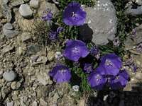 Carpathian Bellflower
 Zăganu cliffs
 Piatra Altarului
Altar Rock
Piatra Altarului
Altar Rock Gâtul Iadului
The Neck of Hell
Gâtul Iadului
The Neck of Hell Peretele Bardos
 Piatra Poienii
 Poiana Alba, White glade
 Hăghimaşul Negru