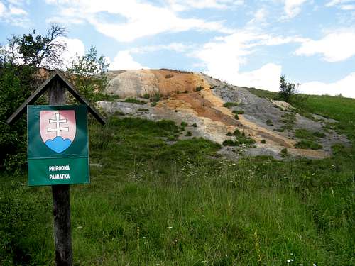
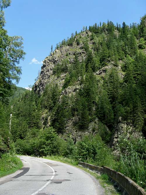
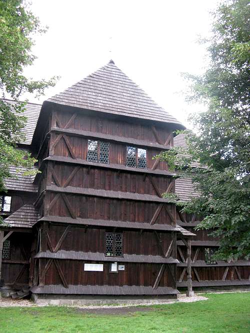
From the Bešeňová travertine hill to the Belianska cave - the only one opened to the public in the Bela Tatras. From the Articular church in Kežmarok - a UNESCO's World Cultural Heritage via Lubovniansky Castle to the ruins of Šariš Castle. Hronsek Wooden Church - a UNESCO's Cultural Heritage and Badín Primeval Forest
From the Zugreni gorges via the Ceahlău Massif with thelegendary conglomerate formations to Mud Volcanoes - being one of the most spectacular Carpathian wonders. Excursions to Prejmer Fortified Church - a UNESCO's World Cultural Heritage, Râşnov Citadel and the famous Dracula's Castle in the Bran resort. From the Dâmbovicioara canyon via the Horezu Monastery - a UNESCO's World Cultural Heritage to the remote Godeanu Mountains.
Let’s set out on an enthralling trip through the most extensive mountainous area on the old continent…
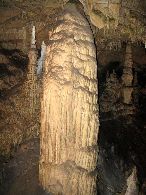
A visit to Belianska cave - the most beautifully decorated cave in the Tatras. This cave was equipped with electric lighting in 1896 as one of the few in the world.
Huge stalagmite
We admire flowstone waterfalls, pagoda-like stalagmites and small lakes during our more than 1 km long underground tour featuring eight domes: Dome of explorers, High dome, Palm hall, Chamber of bandit, Dome of large limestone waterfalls, Gallery, Music hall, White dome.
ZAKOPANE – MUROWANIEC - ZAWRAT - KOZIA PRZELECZ - SIKLAWA - MORSKIE OKO - PALENICA BIALCZANSKA (distance covered on foot: 33 km)
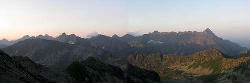
A captivating exhibition showing historic snapshots of the High Tatras. An extremely arduous overnight ascent from Zakopane to Zawrat pass. Morning panorama of the north faces of the Slovak part of the High Tatras.
Stitched panorama of the High Tatras
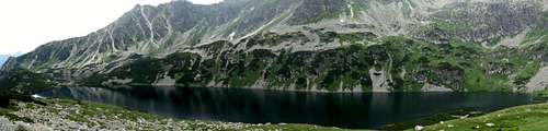
The Eagle Path - perhaps the most difficult hiking trail in the Carpathians. Waymarked with red stripes, this trail is one-way between Zawrat Pass and Kozi Wierch. Numerous exposed sections assisted by chains. Reaching Kozia Przełęcz which ranks first of all the cols in fatal accidents. The decision to descend via the yellow striped trail to the Valley of the Five Polish Tarns. A welcome rest enriched with the observation of chamois. Down the blue striped trail along the Great Polish Tarn - the deepest (80m) and the longest (1km) lake in the High Tatras.
Stitched panorama of Big Polish Tarn
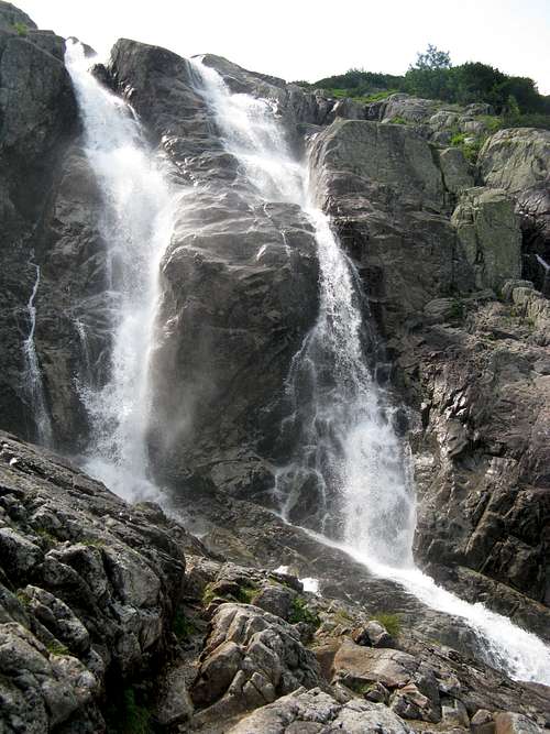
A short look at nearby Siklawa - the most abundant and the highest (70m) waterfall in the Polish Tatras.
Siklawa
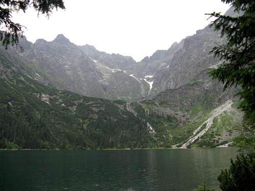
A lenghty descent towards Morskie Oko - the largest (35 ha) tarn of the Tatras as well as the entire Carpathian arc. A 3 km long circuit with a look at Czernostawianska Siklawa.
Morskie Oko
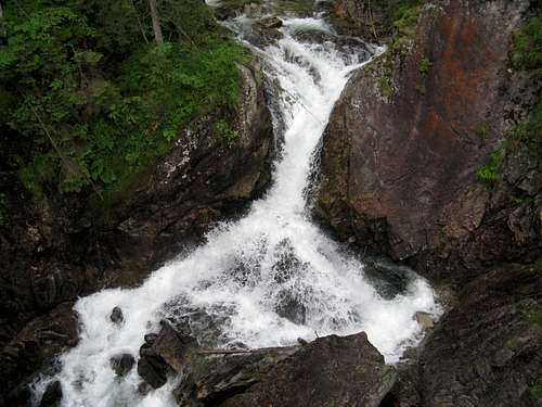
The system of three cascades (120m) named Wodogrzmoty Mickiewicza surrounded by arola pristine woodland.
Mickiewicz cascades
The endless valley of the Bialka river. Finally, I reach Palenica Bialczanska after almost 20 hours of hiking in the Polish Tatras.
A visit to the Lubovniansky Castle with a large complex of interesting expositions. The system of internal walls allocates four
courtyards, three palaces, two bastions and gates as well as one tower. We have a look at the following components: Baroque bastion, Renaissance tower with Boner's gate, Baroque palace, The western renaissance bastion, Baroque chapel, Renaissance palace and Gothic tower.
Lubovniansky Castle
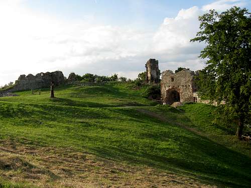
Built in 1245 on anandesite hill, Šariš Castle belongs in the largest medieval fortresses of Slovakia (4,5 ha).
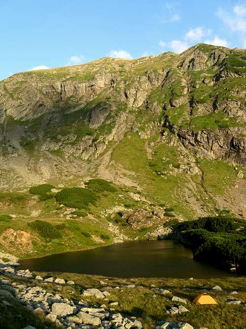
SYNEWYR – OZERTSE (camping) - V.GROPA – NEHROVETS – HORB (return) (distance covered on foot: 30 km, elevation gain:1 000 m)
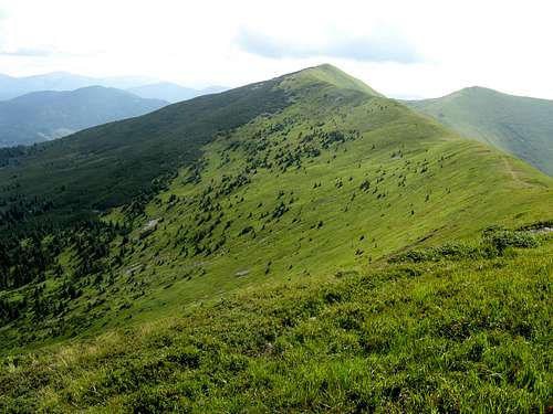
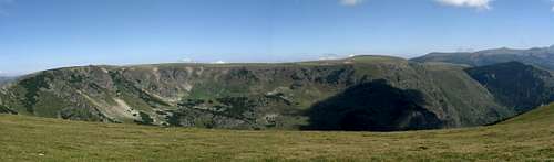
Located in the northern part of Transcarpathia, Polonyna Pishkonya has about 7 km long main ridge oriented NW–SE, but the eastern ridge runs SSW, thus forming a huge arc rising above the valley of the Terebla river.
Video TR
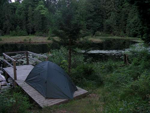
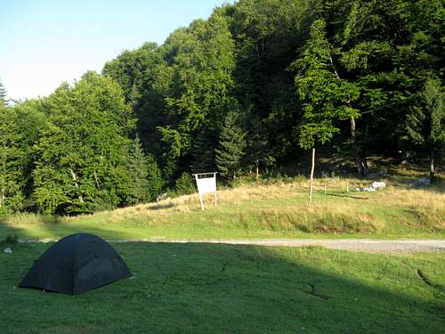
I follow the red striped trail winding along the Terebla river. The checkpoint of Synevyr National Park and springs of clear water. I pitch my tent on the shore of Ozertse tarn.
Campsite on the shore of Ozerce
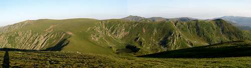
An early morning ascent at timberline with a catch of nutcracker. I reach the summit post of Pishkonya at sunrise. The main ridge trail towards the first summit of Mala Gropa with a cross. A look downhill to Kolochava village. I climb the Jasenovec and Velyka Gropa summits. W face of the highest summit of Polonyna Pishkonya named Nehrovets (1709m).
Nehrovets - the highpoint of Pishkonya
Fine views of the Gorgany in the north. A tiny cirque in the NW side of Nehrovec, with a small tarn. Carnation and aconite species of the mountain flora. I reach the last summit of Pishkonya called Horb. It is situated about 1 km east of Nehrovec and we can find tiny tarns on its NE spur. A time-lapse shot of light and shade enveloping the Hrebin ridge. On my way back I observe a raven and a frog as well. I say goodbye to Ozertse and continue losing elevation. The interpretative trail winding through a patch of pristine woodland. Crossing the bridge by the former museum of rafting. I follow the yellow striped trail along the Ozerianka river, passing by one of the bunkers of Arpad's line. I come back to the directorate of Synevyr NP with information boards.
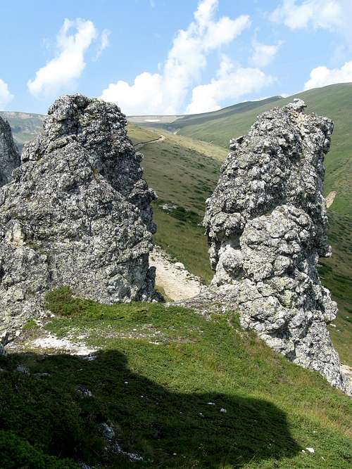
Zugreni Gorges are located in the northern part of the Bistriţa Mountains about 20 km east off Vatra Dornei resort. This natural preserve was established in 1973. It protects a 3 km long and 200 m wide canyon with meanders of the Bistriţa river surrounded by steep cliffs up to 300 m tall.
Video TR
I pitch my tent near Zugreni hut situated in the center of the namesake gorges right on the bank of the Bistriţa river.
Romantic Campsite
A board at the beginning of the Zugreni gorges. The first cliff called Colţul Acrii. A huge 180° meander of the Bistriţa river. A rest place with the signpost pointing to the Rarău–Giumalău Mountains. I pass by the crag named Piatra lui Osman. A colourful alpine plant. A look back to Zugreni hut with the Ţepuşelor massif in the background. Steep slopes on the opposite bank of the Bistriţa river. Captivating rock outcrops called Râpa Scara.
Râpa Scara
A 120° meander of Bistriţa river with cliffs named Grindul Puşcaţei. A Carpathian bellflower. The last cliffy wall called Stânca Coifului. The last meander and a rest place. A board marking the end of Zugreni gorges.
Also nicknamed as the Olympos of Moldova, the Ceahlău Massif represents one of the most spectacular mountain units in the Eastern Carpathains.
Stitched panorama
I cross the viaduct with fascinating views of 23 m tall Piatra Teiului surrounded by the waters of Izvorul Muntelui reservoir - 35 km long being one of the largest in Romania. I arrive at well known mountain resort named Durău - a home for an orthodox monastery. The entrance to Ceahlău National Park. I follow red cross trail and start one of the most arduous ascents I have ever experienced via Cascada Duruitoarea - one of the most impressive waterfalls in Romania - with wooden ladders enabling access over the exposed sections. I go on ascending the steep slope offering first views of Piatra Ciobanului.
Piatra Teiului
Cascada Duruitoarea
Piatra Ciobanului
I reaching the edge of a plateau in the central part of the Ceahlău Massif, passing by strictly protected scientific reserve and heading towards another peculiar rock formation called Piatra Lăcrimată, resembling weeping human face. A wooden cross with Toaca - Piatra Ciobanului massif in the background. I pitch my tent at the only designated campsite in the Ceahlău massif, located at Piatra Lata din Ghedeon. I have two-hour long conversation with a lone Carpathian soul (CZ).
Piatra Lăcrimată
Toaca - Piatra Ciobanului
Campsite
The next day I climb the second highest peak named Toaca with meteo station on its top. I stare at Panaghia - the most emblematic rock tower situated half a kilometre NE. I lose elevation in order to have a look at spectacular needle - Cuşma Dorobanţului - resembling an armed soldier with a cap.
Toaca
Panaghia
Cuşma Dorobanţului
On my way back to Dochia hut, I have an encounter with a viper seen at red striped trail. Sunlit parts of unusual rock formations named Castelul, Faraonul, Vulturul lui Traian and Santinela. Slowly losing elevation to Detunatele - two crags named Cetăţuia si Călugarii. I follow an interpretative trail, shot an edelweiss and learn about the Ceahlău conglomerate. I reach Poliţa cu crini - a characteristic ledge marked by belts of 30 m tall larch trees.
Detunatele
Edelweiss
Poliţa cu crini
In the evening I have a look at massive block called Gardul Stănilelor, wooden church in the heart of the Ceahlău Massif and substantial spring named Izvorul Rece.
Clăile lui Miron
Ocolaşul Mare
Ocolaşul Mic
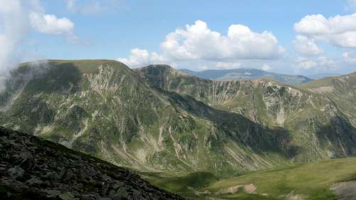
Sunrise over Izvorul Muntelui reservoir. A traverse of Ocolaşul Mare - the highest point, surrounded by cliffs on three sides which boast so called Coloana Dorică, being in stark contrast to table-like grassy N face. I have a conversation with three RO hikers and we are lucky to observe a herd of chamois. I pass by twin-peaked rock towers named Clăile lui Miron. A steep descent to Poiana Maicilor affording the best view of Ocolaşul Mic - a spectacular gallery of limestone and conglomerate cliffs. I say goodbye to the Ceahlău Massif considered to be the homeland of dacian god Zamolxis and finally reach Izvorul Muntelui hut.
An unforgettable visit of a real Carpathian wonders.
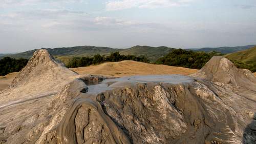
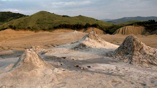
Lunar landscape
Small Paclele (Vulcanii Noroioşi de la Pâclele Mici) are located at 341 m altitude with an area of 16,5 ha. This geologic preserve shelters the most distinctive forms of mud volcanoes with larger cones. Their height varies between 2 and 6 meters. Although the edges of craters seem solid, they are surrounded by slowly moving flow of mud. Due to this fact, these craters often join together forming huge vents of volcanoes sporadically reaching 3 meters diameter.
Mud Volcanoes
Bubble
Great Paclele (Vulcanii Noroioşi de la Pâclele Mari) are situated 2 km NE off Small Paclele. Their altitude is 322 m and area 22 ha. The name of this nature reserve originates from the three main volcanoes and volcanic plateau in the center.
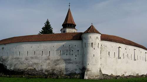
A visit of Prejmer Fortified Church - a UNESCO World Cultural Heritage and one of the most important medieval historical monuments in Transylvania. It has the most fortified walls of any of the fortified churches of Transylvania. The height of ring walls is between 12 – 14 metres, with thickness of up to 5 metres.
Prejmer Fortified Church
The construction of the Church of the Holy Cross began in 1218 by the Order of the Teutonic Knights. Inside the fortress complex, there are over 270 rooms for refuge and storage of provisions, making it one of the most advanced systems of its kind. It preserves ethnological and historical values illustrating the life of multi-ethic community in permanent exhibition.
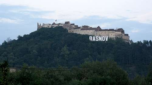
Situated in the vicinity of Brasov between Bucegi and Piatra Craiului mountain ranges, Râşnov Fortress is one of the best preserved peasant citadels in Transylvania. This historical monument and landmark of Romania is located at the rocky hill towering more than 200 meters above the town of Râşnov.
Video
Râşnov citadel is composed of two courtyards. The exterior courtyard is located in front of the eastern wall, edged by a fortified wall and fitted with square tower. The walls are 5 meters tall and the widest part is constituted by the south wall which is about 1,5 meters thick. The interior courtyard represents the inhabitable area having better protection. The strongest fortifications are found in the eastern side of the citadel. Fortified element defending the gate – barbican – was constructed in the 16th century. It belongs in the smallest of its kind in Transylvania.
Râşnov Fortress
Râşnov fortress is a national monument overlapped on a settlement of Neolitic and Bronze Age and further on over Cumidava Dacian fortress. Strategically situated by trading route connecting Transylvania and Walachia, this citadel was designed as a place of refuge over the extended periods of time. Nowadays this ancient fortress has been restored to its former glory.
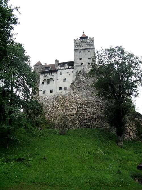
Surrounded by an aura of mystery and legend the 60m tall Bran Castle owes its worldwide fame to the myth created around Bram Stoker’s Dracula.
I enter the Guards room and admire documentary exhibition including the history of Bran Castle, a billboard with portraits of Transylvanian leaders and reproductions of vintage photos of Princess Ileana and its children – Dominic Habsburg-Lothringen, Maria-Magdalena Holzhausen and Elisabeth Sandhofer. The first floor lobby follows. During the interwar period it was arranged as the apartment of Queen Mary of Romania. Nowadays we can see pieces of furniture from 18-19th centuries, tin box decorated in brass and artistic paintings as well.
The next room was arranged as The bedroom of Queen Mary of Romaniaduring the interwar period. From 1938 until the end of 1947 it belonged to Princess Ileana of Romania.
I pass through the Crossing room and enter the Room of the Castellans. There are exposed panels containing informations about castellans, the oath of the chief magistrate, a table in late renaissance style with seats from the 19th century, a bronze sculpture made by Princess Ileana of Romania with a portrait of judge and castellan Lucas Hirscher. Big salon follows with a set in Baroque style, a gaming board, traditional carpets from Wallachia and a Romanin Icon. Then we enter the Secret staircase and go on ascending the stone steps which connect the first and the third floor. We reach the Music hall with an upright piano made in Dresden and library. The interior is decorated in eclectic style reminiscent of the bygone atmosphere. The fireplace is decorated with pieces of folk pottery and a metal vessel. Ring a bell and an angel gets its wings-a memory of an encounter with angels when Princess Ileana was 7 years old.
Video
The Loggia was arranged as summer dining room during the interwar period.
The Terrace was built in the old attic of the fortress during the restoration works. It affords fine view of the old Customs House and the traditional commercial road winding below Bran Castle. We come back to the interior entering the Game room and admire a beautiful game set, which is exposed here. The room of Prince Nicolas of Romania on the fourth floor follows. In the place which used to be the salon, the arrangement of the museum groups pieces from the 18th-20th centuries.
Bran Castle is among several representative locations in Romania, which are linked to the famous Dracula’s legend. The Dracula character was created in 1897 by the Irish writer Bram Stoker in his novel based on the life of the best known Romanian personality named Vlad Tepes/The Impaler. This Prince of Wallachia was given such a nickname due to his cruel methods used in the execution of prisoners. The name that made him even more famous was Dracula.
Bran Castle
We enter the Second floor hall. After 1920 it was arranged as an apartment for King Ferdinand I of Romania. Nowadays documentary exhibition includes a panel with his biography. Bedroom of King Ferdinand I of Romania follows. There is both the tile stove dating from 1762 and the glass-case with the crown and ceremonial scepter. Then we have a look at Living room with a set of dining in neorenaissance style and decorative pieces in cast bronze.
Exhibition in the Hall of Costumes includes two Romanian emblems and popular costumes of Princess Ileana, Vlad Tepes and Mihai Viteazul. The room of the arms follows. We can admire shields decorated with the emblem of Transylvania and two complete armors with helmets and a breasplate. The defense corridor used to connect the defense towers and to facilitate the access of the garrison in case of assault to shooting openings oriented towards road.
There is possibility to visit the Cinema room where eight minute movies with Queen Mary and the royal family are played back. Finally, we have a look at Elevator plant and Engine room.
Dâmbovicioara canyon is 2 km long and can be found in the southern part of the Piatra Craiului mountains. This fabulous gorge is carved in the formations made of sedimentary rocks, limestones and sandstones. Water erosion created authentic ravine with 200 m tall vertical walls, bizare towers, sharp cliffs and underground karst elements.
Vertical wall
Basking in the morning sunshine
Karstic corner
Located 1 km north of namesake village in the karstic zone of Rucăr – Bran corridor, being one of the most impressive of its kind in Romania, Dâmbovicioara cave is formed in jurassic limestones of the Piatra Craiului massif. This cave is easily accessible to a public through 250 m long passage with galleries up to 4 metres wide and 5 meters high. About 10 m tall chimney connects its interior with the exterior, providing suitable microclimatic conditions with moderate humidity and temperature varying between 10 – 12°C. It contains remains of a cave bear and formations with strange names like Eagle's wing, Head of a snake or Leopard's skin.
Entrance to Dâmbovicioara cave
La Galgoaie
Interior
There is a fine cascade called La Galgoaie located at the confluence of Dâmbovicioara creek with Muierii valley. One of the curiosities of this area is restored water mill.
Video
Dâmbovicioara canyon presents picturesque corner and significant component in famous karstic zone which boasts the largest complex of gorges in Romania.
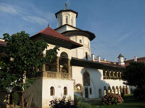
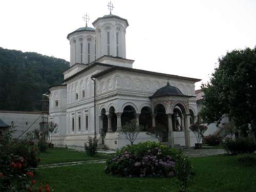
The monastery of Horezu is the most important monastic site in Wallachia. It is considered to be a masterpiece of „Brancoveanu art“ well known for its architectural purity and balance, the richness of its sculpted detail and its painted decorative works.
Video
The name of the monastery comes from „huhurez“ - eagle owls. The legend has it, that the workers were forced to construct it only overnight, when the eagle owls are active.
Horezu Monastery
Horezu monastery was founded in 1690 by Prince Constantin Brancoveanu. In the beginning, the monastery of Horezu was designed only for monks, but in 1872 it became a nun monastery. Since 1993 it has been included in the UNESCO's World Cultural Heritage.
The Big Church
The entire monastic complex covers more than 3 ha. The authenticity of the architecture, paintings, carved stone and wooden decorations in Horezu makes this exquisite culturul heritage the landmark of the Brancovean style. Being restored during communist period, Horezu Monastery is one of favourite pilgrimage sites in Romania.
A 6-day trek in remote Godeanu Mountains started in Jiu-Cerna pass with a rare catch of Ural owl.
Jiu-Cerna pass
1.day: Pasul Jiu-Cerna - Plaiul Sturul - Paltina - Scurtul - Gârdomanuldistance covered on foot: 8 km, elevation gain: 1 000 m
An arduous ascent via beech woodland to timberline. The first views of the eastern part of the Godeanu Mountains.
Vf.Paltina
Vf.Sturu-Paltina - Vf.Scurtul - Vf.Gârdomanul
Vf.Scurtul
Scenery of wilderness in Soarbele valley separating the mountains of Godeanu from Retezat Mic. I climb Sturul peak and reach the main ridge trail (red stripes). Misty weather and precarious orientation. Moreover, I hear the shepherds dogs (a dozen of them). A decision to wait patiently (about half an hour) until the flock of sheep dissapear. Rocky terrain and frightened horses. A traverse of NW faces of Paltina and Scurtul summits. I pitch my tent near Gârdomanul massif.
2.day: Gârdomanul - Galbena - Lacul Scărişoaradistance covered on foot: 6 km
Morning panorama of the eastern face of central and western section of the main ridge seen from Gârdomanul summit. A small tarn sitting at the foothills of Galbena peak and views of distant range of the Retezat Mountains with its highest peak named Peleaga. A traverse of Gârdomanul peak.
Vf.Galbena
Morning panorama
Vf.Gârdomanul
I climb an unnamed summit affording spectacular views of Borăscu plateau with dramatic glacial cirque at the valley head of Galbena de Nord creek.
Borăscu plateau
Time-lapsed shot of cloud moving over the rocky outcrop. I reach Stâna Mare summit and experience a collision of two flocks of sheep. Moreover, a couple of shepherds dogs are approaching me and lie down on the grass at a distance of 5 meters. They are very cute and I am allowed to coudle with one of them:D After an hour pause I continue ascending the Galbena peak. The weather changed rapidly and I find myself trapped in mist, resulting in another forced half an hour break. Drops of rain and lightnings make me to dislocate as quickly as possible. A traverse of Micuşa massif with shrubs of rhododendrons and carpets of aconites. A thunderstorm when losing elevation via an endles path towards Scărişoara lake.
3.day: Lacul Scărişoara - Micuşa - Piatra Scărişoarei - Saua Mâtuluidistance covered on foot: 5 km
A morning ascent to Micuşa summit affording fine views of glacial cirque and Scărişoara lake with Gugu peak in the background.
Central part
When traversing Piatra Scărişoarei in misty weather, suddenly I find myself enveloped by another flock of 300 sheep. An impressive scenery of the most important Moraru - Gugu spur.
Moraru peak
I reach strategic pass named Saua Mâtului and spontaneously decide to pitch my tent here. I hear voices of mountain rescue team marking the main ridge red striped trail. I show them my online maps of the Godeanu Mountains and they respond by writing a contact and welcome info about the nearest source of water. Time-lapsed shots of rushing clouds coming from south oriented valleys.
4.day: Saua Mâtului - Lacul Godeanu (back) - Piatra Scărişoarei - Bisericile din Bulzdistance covered on foot: 16 km
I follow the main ridge trail towards SW. A flock of sheep in the saddle. A look at rocky and grassy face of Vf.Godeanu. Namesake tarn sitting at its eastern foothill. I come back via tiny pass affording fine views of both Cârnea valley (where used to be the largest glacier) and Tarcu Mountains.
Vf.Godeanu
Vf.Micuşa
Vf.Piatra Scărişoarei
Trio of RO geographers with excellent knowledge of surrounding mountains and peaks. A look back at Vf.Micuşa and traverse of Vf.Piatra Scărişoarei with rocky s face. Protracted descent towards fairy conglomerate formations called Bisericile din Bulz. Exhaustive return to Mâtului saddle and a shot of opposite Oslea massif basking in the evening sunshine.
Bisericile din Bulz
5.day: Saua Mâtului - Moraru - Gugu - Lacul Gugudistance covered on foot: 5 km
Saying goodbye to strategic pass. Strong wind and mist resulting in precarious orientation. I climb the second highest peak named Moraru, having in-depth look at namesake tarn. A traverse of Scarită summit and the beginning of tedious ascent to the highest point of the Godeanu Mountains. I reach the top of Gugu peak, affording spectacular views of the main ridge of the Tarcu Mountains and Corhale - Prislop ridge as well. Wild valley of Ses creek. A spontaneous decision to descent to Lacul Gugu and pitch a tent at this mysterious corner.
Vf.Gugu
Lacul Gugu
6.day: Lacul Gugu - Gugu refuge - Gura Apeidistance covered on foot: 8 km
Beautifully-lit glacial cirque of Gugu peak. A catch of both four chamois grazing under Gugu tarn and lesser spotted eagle soaring over me.
Kogaionon
Saying good bye to this sacred mountain. I pick tasty blueberries and continue losing elevation through captivating wilderness full of engravings of wild boars. I hear the rustle of Branul creek with its cascading waters more than a hundred meters below my feet. A traverse of Branul massif with a spring of fresh water. An information board dealing with flora and fauna of the Godeanu mountains. Suddenly, I find myself at Gugu refuge and read an interesting legend about Gugu summit.
Gugu refuge
A steep descent via pristine spruce woodland to the valley of Lapusnicul creek. I have to bushwhack a bit and finally reach dirt road winding along Gura Apei reservoir.
Mures riverside
A short visit of Lunca Muresului NP. Information boards dealing with vegetation and very rare catch of the European bee-eater. Bezdin monastery founded in 1520. Destroyed observation tower Libus András and an insight into the interior of floodplain forest. Intrusive horseflies, the first hide and a transfer to the second hide. Premature exit of this lowland stretching along Mures river near RO/HU border.
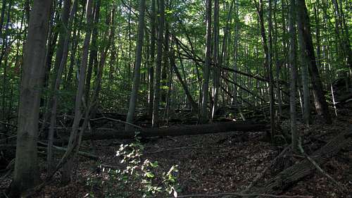
An insight into the interior of Badín primeval forest nature reserve established in 1913. It boasts 300 years old beech trees almost 50 m tall and 150 cm in diameter.
Badín pristine woodland
Summary
Travelling through 4 Carpathian countries
Overall distance covered on foot: 220 km
Overall distance covered by other means of transport: 3,100 km

 )
) )
) )
) )
)


 Piatra Teiului
 Cascada Duruitoarea
 Piatra Ciobanului
 Piatra Lăcrimată
 Toaca - Piatra Ciobanului
 Campsite
 Toaca
Toaca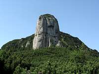 Panaghia
 Cuşma Dorobanţului
 Detunatele
 Edelweiss
 Poliţa cu crini
 Clăile lui Miron
 Ocolaşul Mare
 Ocolaşul Mic
 Mud Volcanoes
 Bubble
 Vertical wall
 Basking in the morning sunshine
 Karstic corner
 Entrance to Dâmbovicioara cave
 La Galgoaie
 Interior
 Vf.Paltina
 Vf.Sturu-Paltina - Vf.Scurtul - Vf.Gârdomanul
 Vf.Scurtul
 Vf.Galbena
 Morning panorama
 Vf.Gârdomanul
 Vf.Godeanu
 Vf.Micuşa
 Vf.Piatra Scărişoarei
 Vf.Gugu
 Lacul Gugu