
-
 21181 Hits
-
 93.81% Score
-
 44 Votes
|
|
Area/Range |
|---|---|
|
|
49.24000°N / 20.22000°E |
|
|
Hiking, Mountaineering, Bouldering, Ice Climbing, Mixed, Scrambling, Skiing |
|
|
Spring, Summer, Fall, Winter |
|
|
7060 ft / 2152 m |
|
|
Forgotten mountains
Belianské Tatry (sk) - Tatry Bielskie (pl) - Beler Kalkalpen (de) - Bélai-havasok (hu)
!!!I´M WORKING ON THE PAGE!!! IF YOU ARE INTERESTED IN PARTICIPATION ON THE CREATING OF THE PAGE, FEEL FREE TO ASK ME FOR EDITOR RIGHTS!!!
THANKS TO THE SP MEMBER AND EDITOR OF THE PAGE GORZI THIS PAGE WAS ENRICHED BY A GREAT DEAL OF INFORMATION. THANK YOU!!!
THANKS ARE DIRECTED ALSO TOWARDS SP MEMBER PETER BUDAI FOR ADDING VERY USEFUL MATERIAL AS WELL AS FOR CORRECTING SOME MISTAKES IN HTML CODE OF THE PAGE.
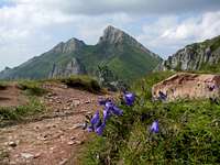
This small range is sometimes considered to be a part of the range Vysoké Tatry /High Tatras/, from which it is separated by Kopské sedlo (pass). Its limestone main ridge is 14 kilometres long and not accessible by hikers or climbers because of protecting of chamois and scarce mountain flora. Its highest point is Havran (2152 m) and the nicest one is Ždiarska vidla/Placliva skala (2148 m).
 Havran and Ždiarska vidla Havran and Ždiarska vidlafrom Javorova valley |
 Ždiarska vidla (2148 m) Ždiarska vidla (2148 m) |
 Muráň (1890 m) Muráň (1890 m) |
Overview
Belianské Tatry - this 14 km long limestone and dolomite ridge (covering an area of 67 km2) belongs to Eastern Tatras (High Tatras and Belianské Tatras). The mountains were named after the city of Spišská Belá.
The main ridge of Belianské Tatry runs almost parallel to the main ridge of High Tatras. The beginning of this ridge is on Kobylí vrch (1108 m) and the ridge ends in Rogová (1166 m) above Tatranská Javorina:
Kobylí vrch (1109 m) - Kobylé sedlo (1090 m) - Fajxová (1488 m) - Fajxove sedlo (1480 m) - Kozí chrbát - Skalné vrata (1620 m) - Bujačí vrch (1947 m) - Bujačie sedlo (1903 m) - Holica (1981 m) - Košiare (2012 m) - Predné Jatky (1950 m) - Prostredné Jatky (1984 m) - Zadné Jatky (2020 m) - Šialené sedlo (1936 m) - Hlúpy (2061 m) - Široké sedlo (1825 m) - Ždiarska vidla (2142 m) - Tristárské sedlo (1969 m) - Havran (2152 m) - Havranie sedlo (1932 m) - Nový (1999 m) - Nové sedlo (1825 m) - Muráň (1890 m) - Muránska veža - Malý Muráň - Muránske sedlo (1378 m) - Kôň (1356 m) - Rogová (1166 m).
Belianské Tatry are divided by pass Široké sedlo into two parts: western - with the highest point Havran (2152 m), and lower eastern part (Hlúpy 2061 m).
 Belianské Tatry viewed from Jahňačí štít (western part: left, eastern part: right)
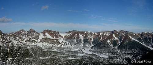 Belianské Tatry viewed from Veľká Svišťovka
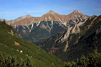
These mountains are rich carst area. You can find here a lot of caves, but only one - Belianska jaskyňa cave on the slopes of Kobylí vrch - is open for public. The other caves: Tristárská jaskyňa (500 m long), Havrania priepasť (45 m deep), and Havrania diera (120 m long) in the area of the highest peak Havran. More in the section Under the limestone surface.
First visitors of this terrain were probably the shepherds in the 14th century. In the 17th century there have emerged mining activity (iron and copper ore).
The northern parts of the Belianské Tatras are home to the largest population of the Tatra chamois, which is endemic to the Tatras. The typical flower of the mountains is Edelweiss.
The northern slopes are drained by Biela Stream and its tributaries (Rígeľský potok, Tokárenský potok, Babí potok). Tributaries of Javorinka are draining a part of northern slopes west of Havran (Nový potok) and part of southern slopes west of Hlúpy so called Zadné Meďodoly (Štefanka, Meďodolský potok). Eastern part of southern slopes, so called Predné Meďodoly are drained by Napájedlový potok, feeder of Kežmarská Biela voda. There are no lakes nor waterfalls.
 Ždiarska vidla and Havran Ždiarska vidla and Havranfrom Ždiar |
 Belianské Tatras ridge Belianské Tatras ridgefrom Zelena Javorova valley |
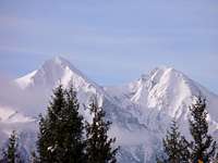 Ždiarska vidla and Havran Ždiarska vidla and Havranfrom Jezersko |
Highest points
Havran - 2152 m, the highest point of Belianské Tatry, and highest limestone mountains of the whole Tatras. It is located in the western part of the main ridge of Belianské Tatry. By the Havranie sedlo it is separated from Nový (west) and by Tristárské sedlo from Ždiarská vidla (east). Havran is rising up over Havrania dolina Valley (north-west), Tristárský žlab (north-east) and Zadne Meďodoly (south). About 250 m in the north direction from summit, there is Vyšná Havrania strážnica. The name of this mountain means >>The Raven<<. Havran was called Panská vidla too, in the memory of the owner of this area, the prince Christian Hohenlohe.
The easiest way leads from Zadné Meďodoly. It takes 2 hours, but it is forbidden. The trail led from Javorina to Kopské sedlo and to Polana pod Muráňom. From there we are going to Havranie sedlo, and from there 30 minutes to the summit of Havran. Another way: from Podspády through Havrania dolina - 2 hours 30 minutes.
Ždiarska vidla - 2142 m
 Havran (2152 m) and Ždiarska vidla (2142 m) in main ridge of Belian Tatras
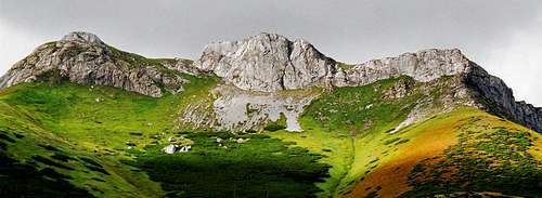 Predné Jatky (1950 m) and Košiare (2012 m) in main ridge of Belian Tatras
Hlúpy - 2061 m
Zadné Jatky - 2020 m
Košiare - 2012 m
Nový - 1999-2009 m
Holica - 1981 m
Prostredné Jatky - 1980 m
Bujačí vrch - 1961 m, mountain in the eastern part of Belianské Tatry, between Jatky and Kozí chrbát ridge. It has two summits: western, higher (1960 m) and eastern (1946 m). The former Tatranská magistrála has lead over the lower summit. The name is derrived from folk word bujak = bull.
Muráň - 1890 m, first known ascents: István (Štefan) Berzeviczy in 1717, Feliks Berdau in 1854, Franz Dénes in 1863, Ludwik and Tytus Chałubiński with friends in 1878. It is named after its shape, this mountain looks (from all its sides) like a wall (in Slovak: múr). From the summit leads two ridges: north-western and northern, which ends after some 400 - 450 m with a vertical walls. Between those ridges, there is located a small pasture, Jahňacia zahrada (Sheeps yard); 1625 m -1850 m. Shepherds from Jurgov, Čierna Hora and Repiska bring here their sheeps, and they stay here all the summer.
Getting There
Approach directions for Belianské Tatry mostly overlap with those of its western neighbour, the High Tatras. From Slovakia, the town of Poprad is the main point of access.
From Poland: come via Tatrzańska Bukowina (rather than Zakopane, which is for the High Tatras).
By public bus: still the same old way: Kraków - Zakopane - Lysa Polana - Zdiar.
By car: (thanks to the Schengen pact): Kraków - Nowy Targ - Jurgów - Podspady - Zdiar.
Red Tape
 Botanical garden
 Carpathian chamois
Since 1978 is this area closed for public by TANAP. The main reason is protection of valuable flora and fauna (chamois). In 1993 TANAP has opened one interpretitive trail: Monková dolina Valley - Kopské sedlo Saddle. Today, the whole area is a national nature reserve covering 54.08 km2, which is part of Tatra National Park (TANAP).
Under the limestone surface
Belianska jaskyňa / Belianska cave
The Belianska cave is located on the northern slope of the Kobylí Hill (1109 m) in the eastern edge of the Belianské Tatras Mts. Its original entrance was at the height of 972 m, the current entrance is at the height of 890 m. The cave is 3641 meters long and 160 meters deep. Its main attractions are the flowstone waterfalls (High Dome, SNP Dome, Waterfall Dome, Musical Hall) and pagoda stalagmites (Palm Hall).
The cave must have been known to gold miners a long time ago, the first signs of human presence date from the 18th century (inscription on the wall: "Michael Scholtz 1713"). Its entrance was re-discovered by two gold miners (named Gulden and Fabry), but wasn't explored and got forgotten again. The first "official" explorers were Julius Husz and Johan Britz in July 1881, who baptised it the "Cave of Lakes". A report of its first scientific survey expedition is available here ("A Tóbarlang a Kínos-völgyben" - pp665, in Hungarian). Further discoveries were made by A. Kaltstein, I. Verbovszky, S. Weber and J Britz in 1882.
Belianská jaskyňa was opened for public 6.8.1882. There is no other cave open to the public in High Tatras and Western Tatras. Today, an educational trail leads to the cave entrance (which is a man-made tunnel which was blasted in 1885) at the elevation of 890 m from the village Tatranska Kotlina (760 m). The trail is 1,000 m long, and you need to overcome 122 m of altitude.
Is the cave opened today? See the link in your language: everyday info is available in English, German, Hungarian, Polish, and of course Slovak. Admission fees apply (taken from the page of Slovak Caves Administration):
| Adults | 7 € |
|---|---|
| Students and Retired (with valid ID card) | 6 € |
| Children (6 to 15 years) and Disabled | 3.50 € |
| Camera | 10 € |
| Videorecorder | 10 € |
| Non regular entrance | 50 € |
Further caves
| Ľadová Pivnica | On the northeastern slopes of Bujačí vrch; above Alabastrová jaskyňa cave. Entrance with triangle shape (8 m high). 60 m long, 18 m deep. |
| Muránska jaskyňa | On the slopes of Muráň. |
| Jaskyňa v Škaredom žlabe | Below the summit of Nový. |
| Vrchná (Upper), Prostredná (Middle) and Spodná (Lower) jaskyňa | Below Nový vrch. |
| Alabastrová jaskyňa | On the northeastern slopes of Bujačí vrch at the height of 1390 m. Length: 300 m. |
| Kamzičia jaskyňa | Below Zadné Jatky (approximately 20 m below the summit); it is almost horizontal 47 m long tunnel. |
| Tristárská jaskyňa | In the area of Havran, 201 m deep |
| Havrania priepasť | In the area of Havran. |
| Havrania Diera | 110 m long, in the area of Havran. |
| Nová éra | 121 m deep. |
| Sedlákova diera | 309 m long. |
Routes
 On the trail...
Interpretitive trail: Monkova dolina - Kopské sedlo (see this SP album)
Ždiar (896 m) - green marked path - Monkova dolina Valley - Široké sedlo (1826 m) - Kopské sedlo (1750 m) - blue marked path - Zadné Meďodoly Valley - Tatranská Javorina (1000 m). 6 h 30 min
After the closure of Belianské Tatry, Monková dolina is the only one accessible part of these mountains (since 1993). This trail is closed in the period of 1.11. to 15.6. The keeper of this trail is Urbariát Ždiar (association of landowners in Ždiar).
At the entrance to the Monkova dolina you have to pay a fee (50 SKK) and you receive a brochure about the trail.
Huts
 Chata Plesnivec
The only hut in operation in Belianské Tatry is Chata Plesnivec hut in the Dolina Siedmich prameňov Valley, on the south-eastern slopes of Bujačí vrch.
Tel: +421-905-256722
Prices: 220 SKK per night
Access : from Tatranská Kotlina - green marked path (1 h 30 min)
from Chata pri Zelenom plese hut - 2 hours
from Tatranská Javorina - 4 h 30 min
yatsek - Oct 30, 2008 2:50 pm - Hasn't voted
driving from Krakow, PolandBy bus: still the same old way: Kraków - Zakopane - Lysa Polana - Zdiar ... But by car (thanks to the Schengen pact): Kraków - Nowy Targ - Jurgów - Podspady - Zdiar So you actually don't drive through Bukowina but you do drive through Białka Tatrzańska
Tomas Kristofory - Nov 4, 2008 8:18 am - Hasn't voted
Re: driving from Krakow, PolandI included it into the text. Thanks for the correct info how to drive from Poland.