
-
 5012 Hits
-
 83.69% Score
-
 17 Votes
|
|
Mountain/Rock |
|---|---|
|
|
43.41430°N / 103.4675°W |
|
|
Fall River |
|
|
Hiking |
|
|
4120 ft / 1256 m |
|
|
Overview
Catholicon Mountain is located at the north end of the Seven Sisters Range in the southern Black Hills of South Dakota. The small city of Hot Springs is situated at the northwest corner of the mountain, with the Fall River flowing along the northern base. Catholicon Mountain and the rest of the Seven Sisters Range create a scenic skyline to the south of Hot Springs. Though it rises about 750 feet from the river, the mountain is unranked because it is at the low end of the overall slope of the Seven Sisters Range. All the land on the mountain is private and the forest is managed by the National Forest Service. It is an interesting mountain to view, since the profiles change significantly as one circles the mountain. From the north-northeast, the mountain has its most gentle profile, while the view from the west-northwest reveals its steepest slope.
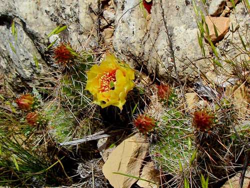 Cactus blossom on Catholicon Mountain
Hiking and scrambling have a long history on Catholicon Mountain, even though it is on private land. Many area residents have climbed to the summit since Hot Springs became a town in 1882 (first called Minnekahta). Unfortunately, the occasional beer cans found on the slopes attest to its popularity with those who do not practice “leave no trace”. Despite Catholicon’s close proximity to Hot Springs, deer are seen in abundance here, along with turkey vultures. Area residents routinely report sightings of mountain lions, possibly from a known lion den a few miles north in Spring Canyon. There are rattlesnakes in the area, but they are not often seen here. At the summit, there is a fire ring. With the great concern about forest fires around here, it is amazing that anyone ever got away with this. Though thickly forested, the summit still presents a great panorama of the area, with several other area summits in clear view, including Battle Mountain and Friendshuh Mountain to the north-northeast, and the Seven Sisters highpoint and Devil’s Slide Mountain to the south-southwest.
 Fall River Falls
Ponderosa pines are the dominant trees on the mountain, with cottonwoods common along the river. There is also an abundance of cactus and yucca plants on the mountain. For hikers who want a little additional fun after a climb, a dip in the Fall River can be very soothing. Most of the thermal springs in the river range from 87 to 97 degrees, which keeps the water temperature always in the 87 to 89 degree range, even in the winter. Not all areas of the river have public access, but the private areas are normally well-marked. You will definitely want to stay away from the pool below Fall River Falls, a few miles downstream from Catholicon Mountain. Multiple drownings have occurred there over the years, prompting local officials to post the area as closed.
History
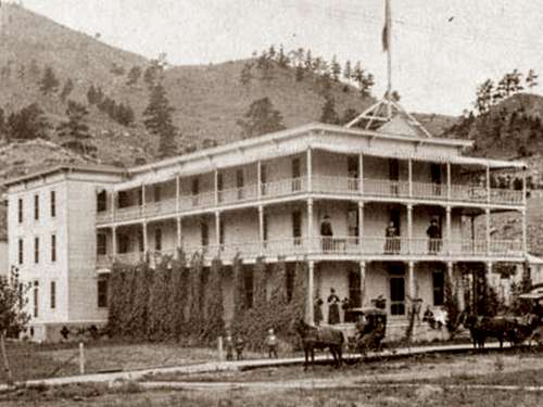 Catholicon Springs Hotel
Long ago, Catholicon Spring flowed out of the foot of the mountain into the Fall River. The old Catholicon Hotel was built next to the spring in the late 1800’s. Eventually, the thermal spring dried up, the hotel closed and was torn down. The mountain and spring were probably named Catholicon because one meaning for catholicon is a “universal remedy”. In the late 1800’s mineral springs were being promoted as “cure-alls” for health problems. The 1895 Medical Herald, Vol. 14, in describing the Catholicon Hotel and sanitarium, reported “The Catholicon Spring unquestionably enjoys the widest reputation for remarkable cures in the vicinity. It rises within a few feet of the hotel building, and it’s perfectly clear waters are accessible to all. It flows out the foot of Catholicon Mountain, which rises 1,400 feet above, is abundant for all uses of the hotel and bath house.” Of course, the mountain does not rise 1,400 feet, but like so many 1800’s advertisements for this area, things got embellished sometimes. The same could be said for all the “cure-all” claims that used to be made for the thermal mineral waters that come from nearly 200 springs in the Fall River valley. The photo at left shows the old Catholicon Spring Hotel & Resort, built next to the Catholicon Spring. Before the spring dried up, it was re-named Hiawatha Spring. One noteworthy feature in the photo is the lack of trees on Catholicon Mountain in the late 1800’s. This would be consistent with the many historical accounts of the Black Hills that tell of mountains only sparsely covered with trees. Better forest fire control plus landowner concerns about logging have led to a different look for the Black Hills since then.
Getting There
Catholicon Mountain is at the southwest edge of Hot Springs, South Dakota. Hot Springs is about 55 miles southwest of Rapid City, at the junction of highways 385, 71, and 18. One good point of access is probably in the area around the south end of South 6th Street, in the area known as “the Catholicon Addition”, where there is some curbside parking options. The Allen Ranch provides another good point of access. There are other points of access, which all will depend on where you choose to start your off-trail scramble.
Route Options
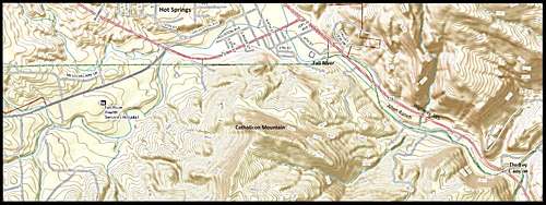 Catholicon Mountain Area Map
As previously mentioned, the whole mountain is privately-owned, and with no trails. Hikers will have to map out their own off-trail route. It would seem reasonable that the best policy for hiking private land is always to obtain landowner permission before planning your hike. However, this view flies in the face of the long-standing local tradition of climbing the mountain when and where anyone wants. Since I have not exhaustively explored all route options, I cannot say for a certainty that the whole mountain is not posted “no trespassing”. But I could not find any such postings in any of the areas I did explore. Further complicating the “obtain permission first” policy is the lack of response from the landowners, or even to locate them. You can always access the latest available official data on who owns the land you wish to access in Fall River County, at this link: Fall River County Online Landowner Map. Googling the various owners will help turn up the latest contact info for at least some of them.
 Fall River Winter
 Fraternity of Ducks
The reason you might have problems communicating with some of the owners, is the fact that some of the land is owned by obscure corporations like the Paha Sapa Foundation and Mountain High Limited. The access on the northeast side, which is the steepest slope on the mountain, is owned by the same family that operates a campground along the river, so normally you can get an answer there. However you decide to set up your hike will certainly depend on where you are able to begin your ascent. The Allen Ranch (see camping info below) probably offers the most certain access to Catholicon Mountain. You can access the Seven Sisters Range North Route from the Allen Ranch, which gives you an option to hike in from the saddle on the south side. Check out the link above or the link in the left column.
When to Climb
 The View Northwest
Snow over a thick bed of loose pine needles on a steep slope never makes for good footing. So winter hiking here is probably not a good idea. The rest of the year is good, though summer lightning and the various hunting seasons would all provide good reasons to plan your hike carefully. The sides of the mountain facing Hot Springs and the highways will not likely have hunters. The back side of the mountain could be a different matter. The local game warden is D.J. Schroeder, who can be reached by phone at: (605) 745-6100. For the latest area weather forecast and conditions, click on the link below: Catholicon Mountain – Hot Springs Area Weather
Red Tape
Since this is all privately-owned land, whatever red tape you will encounter will depend on whose land you are allowed to hike on. Please bear in mind that even though this is private land, the forest is still managed by the National Forest Service, and they have some very great concerns about campfires and fireworks. Discharging firearms this close to Hot Springs could very likely bring you a quick visit from the local police and/or sheriff’s departments.
Camping
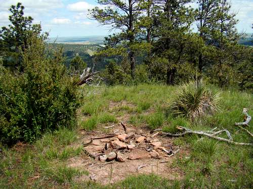 Illegal Fire Ring at the Catholicon Summit
The nearest campground, the Allen Ranch, is right at the foot of the north side of the mountain, along the Fall River. You can contact them by phone at: (605) 745-1890 or you can access their website by clicking here:
The Hot Springs Chamber of Commerce also maintains a current list of campgrounds and lodging in the area, including camping at nearby Angostura Lake. You can reach the chamber by phone at: (605) 745-4140 or you can access their website by clicking here:
Hot Springs Area Camping & Lodging
There is also a campground at Wind Cave National Park north of Hot Springs. You can reach their office by phone at: (605) 745-4600. You can access their website by clicking here:
Wind Cave National Park Campground
Forest Service Information
Hot Springs District Forest Service Office
1801 Highway 18
Hot Springs, SD 57747
(605) 745-4107
Maps
Catholicon Mountain lies in the Hot Springs Quad. The Black Hills South map, published by National Geographic, is an excellent map for the area, as is the Black Hills National Forest Map, sold at forest service offices in the area. If you are exploring any of the national forest lands in the area, the national forest service office in Hot Springs offers a free Motor Vehicle Use Map for the Black Hills National Forest.