
-
 14945 Hits
-
 85.36% Score
-
 20 Votes
|
|
Mountain/Rock |
|---|---|
|
|
47.90381°N / 112.74683°W |
|
|
Scrambling |
|
|
Summer |
|
|
7542 ft / 2299 m |
|
|
Overview
The namesake of the Cave Mountain Recreation Area, Cave Mountain, despite its small stature relative to other nearby peaks, nevertheless packs a lot of punch. It is only two miles to the summit, one of them by trail, but that second mile, which is very steep, features easy bushwhacking, enjoyable scrambling, and dizzying ridge walking. The open summit provides excellent views of the highest peaks of the Sawtooth Range, a subsection of Montana's spectacular and rugged Rocky Mountain Front, considered by many Montanans to be truly Montana's "last best place." Montana itself is sometimes called that, and the Front easily is among the greatest areas of the state.
It's my assumption that Cave Mountain is named for a cave on or near the peak, but such a cave is not marked on the USGS Cave Mountain quad, and I do not know where it exists.
Please note: Cave Mountain's summit is not the one you see as you turn into the Cave Mountain Recreation Area, and it is not the top of the cliffs immediately to the right at the start of the trail. You could reach the summit via those locations, but doing so would be much longer and would require more, and harder, bushwhacking.
Getting There and Route Information
Driving Directions
About five miles north of Choteau, look for a west-heading road with signs indicating fishing and access to the Teton Pass Winter Sports Area. Take this road. 17 miles along, a road will branch left, cross the river, and become gravel. DO NOT take this road. Instead, stay straight (a sign will say you are on 144); the road will soon turn to gravel (well-maintained and probably passable even to a Corvette), enter the mountains, and take you through some gorgeous mountain scenery that almost no one outside Montana knows is there. The Cave Mountain Recreation Area is about 5.5 miles from the fork. Turn there and follow signs to the Middle Fork Teton (Route Creek Pass) Trailhead.
The Climb
The trailhead sign notes several destinations, but not Route Creek Pass. However, it is the only trail here, so there should be no confusion. For reference, users can note that the sign says the Bob Marshall Wilderness (you enter it at Route Creek Pass) is 6 miles away (actually more like 5.4).
Note: the version of the Cave Mountain quad found on TopoQuest.com does not accurately show the location of the trail. It has it starting in the wrong place and also shows the trail following the south side of the West Fork for a bit. The trail was rerouted in recent years, and it actually begins at the 5200' contour and stays entirely on the north side of the West Fork. It is accurately depicted in the version of the Cave Mountain quad that people can purchase directly from USGS. The map shown at the bottom of this page is accurate as well.
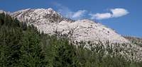
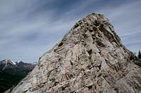
You will hike approximately one mile along the trail before leaving it, gaining only 200' as you go. As you near that mile, you will see the rocky summit ridge of Cave Mountain through the trees (see below); you leave the trail as you reach the south-southwest side of that ridge. A useful reference point is a drainage (most likely dry) that you cross at 0.8 mi. This drains a bowl on the eastern side of the summit ridge, and once you cross this drainage, it is time to start paying attention for the best bushwhacking route to gain the ridge.

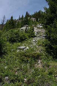
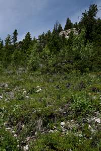
After crossing 5400', leave the trail and head north through some brush for a short distance and start going up steep slopes, aiming for the obvious ridge above but sticking to the S-SW side as much as possible. The photos below show how things look where you leave the trail.
 |
 |
 |
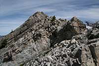
From the trail to the summit, you will gain a little over 2100' in a mile. Much of this is a fun scramble. Once you leave the brushy areas behind and gain the rocky ridge, the route becomes quite enjoyable. As you near what appears to be a pinnacle that is the highpoint (second picture below), you may realize that it will be substantially lower than the 7542 ' summit, and you might start wondering if you are on the wrong ridge and if the correct one is the next one to the west, which looks to top out at about the right height.
 |
 |
 |
All is fine. Once you crest that "pinnacle," you'll see that there's more to go, and once a little higher than that, you will behold the delightful surprise this peak has in store for you-- a long (relative to the route) knife-edge ridge with terrific exposure on the east side and so steep on the west side that sticking to the crest is going to look like the best, if also the scariest, option.
 |
 |
 |
Sticking on or as close as possible to the crest is indeed enjoyable even though it is possible to stay lower and avoid the exposure. Along the crest, expect several spots of Class 3 or 4 terrain, especially where you have to negotiate breaks in the ridge.
 |
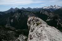 |
Finally, you reach the summit, where the views are superb in every direction. Please peruse this page's image gallery for examples of some of the views.

Red Tape
You are in bear country and one of the best places in the world to encounter grizzlies. Know proper techniques for food storage, and know how to behave if you encounter any bear. Carrying pepper spray is a good idea, but make sure you have tested it and know how to use it. Above all, don't do anything stupid to or around the bears. Don't become a statistic and/or one of those idiots responsible for yet another dead bear.Camping and Lodging
There is a campground at Cave Mountain Recreation Area; the fee is $6 per night. There are water pumps there, but I have never stayed there and do not know if they work. You can also backpack in, sleep in your car at the trailhead, or use a dispersed camping site nearby (free, and fewer flies).You could also stay at a motel in Choteau. It should take you 45-60 minutes to drive from there to the trailhead.
Topo Map
