-
 13729 Hits
-
 83.69% Score
-
 17 Votes
|
|
Mountain/Rock |
|---|---|
|
|
47.88837°N / 112.8395°W |
|
|
Hiking, Scrambling |
|
|
Summer |
|
|
8416 ft / 2565 m |
|
|

Overview
Teton Peak is another of a handful of named alpine peaks in the Sawtooth Range of Montana’s Rocky Mountain Front and is on the edge of the great Bob Marshall Wilderness. At 8416’, it is not close to being one of the highest in the range, but something recommending it, other than the facts that it is there and the summit views are, of course, outstanding, is that it is one of the more remote peaks in the range that can be climbed in a single day. The easiest route to the summit is 15 miles round-trip, with 11 of those miles on a maintained trail. Situated near the center of the range, the peak has summit views that include just about every other major peak in the Sawtooth Range.
Rumor has it that a lonely, homesick Frenchman named the Teton Range in Wyoming for some of the peaks’ resemblance to a part of the female anatomy with which men are known to have a fascination, using the French term or a derivative of it. Perhaps that same man named Teton Peak in Montana, or perhaps someone else had the same idea. In any event, the peak’s pyramid shape is striking, and it even somewhat resembles the Middle or Grand Teton from certain angles.
Something interesting, and encouraging, about a climb of Teton Peak is a significant mistake on the USGS Mount Wright quad, which shows the peak and the route to it. From Route Creek Pass south of the peak, a ridgeline leading to Teton Peak first ascends two unnamed summits marked only as Point 7982 and Point 8779. Following the ridgeline to the peak and back to the pass means a total elevation gain of 3300’ over about two miles. However, Point 8779 is incorrectly labeled, and its actual elevation is about 8175’ (reading the contour lines on a topo map verifies this). That, plus a goat trail that stays a little beneath the ridgeline of Point 7982, cuts 1400’ of round-trip elevation gain and makes the total climb a much friendlier 1900’. I was actually leaning against climbing Teton Peak because of that expected elevation gain over such a short distance for what really is not one of the signature peaks of the range, but I noticed the day before while climbing Old Baldy that there was no way Point 8779 was higher than Teton Peak. Encouraged, I put Teton back into my plans and wound up being very glad I did.
 A look at the route...
Route Information
The pictures in this section show the route progression in order.
Route Creek Pass is itself an excellent destination, and the climb to Teton Peak along the ridgeline north of the pass offers sweeping mountain views in all directions every step of the way. At about 15 miles RT with 4000’ of elevation gain, this route makes for a long day. The off-trail portion of the route can be all Class 2, but there are chances for a little Class 2+ and Class 3 along the final ridgeline to Teton Peak’s summit.
Climbers might consider backpacking in and camping in the vicinity of Route Creek Pass instead. An advantage to this aside from breaking up the climb is that it also offers the possibility of climbing Old Baldy, which is along the ridgeline to the south. That is what I did, climbing Old Baldy in the late afternoon and climbing Teton Peak the next morning. Be forewarned, though, that Route Creek Pass is a terrible place to camp; it is rocky, and there are no flat spots. The nearest flat spots (still rocky) are reached by climbing a few hundred feet above the pass along one of the ridgelines north or south. There are also no trees for hanging food, so it is best to have a bearproof canister for storage of food and other items that emit odors.
The trail to Route Creek Pass follows the South Fork Middle Fork Teton River (yes, that is the name) for 5.5 miles from the trailhead, climbing 2100’. That sounds pretty gentle. But wait. For 4 miles, the trail only climbs 1000’. After a stream crossing at 4 miles in, the real climbing begins, and the last three-fourths mile is especially steep; given that you will probably be hot, tired, and thirsty by then, you will likely be hating every ounce in your pack. Excellent scenery for the last 2 miles helps compensate for the strain.
This trail was rebuilt a few years ago, but the old trail, which stays lower and closer to the river, is still there. It doesn’t make much sense to use the older trail unless you absolutely cannot tolerate sharing trails with horses; Route Creek Pass is an important gateway into the heart of the Bob Marshall Wilderness, and horsepackers use the trail regularly (so expect mud and manure).
When you reach the pass, a tall, triangular peak rises just to the northwest. That is not Teton Peak; it is the mislabeled Point 8779. Teton Peak is not visible from the pass, and it does not come into view until you are a few hundred feet up the ridgeline to Point 7982.
 Point 8779 from Route Creek Pass
 Point 8779 and Teton Peak
From the pass, hike up the ridgeline to the north. Look for the aforementioned goat trail running below Point 7982; using it saves you about 100’ of climbing each way, and side-hilling on the talus without the goat trail is probably more tedious than just going over the peak. You will reach a 7810’ saddle between Points 8779 and 7982, where you will give up any plans of contouring across the mountainside instead of having to climb Point 8779 (remember that it is really more like 8175’); sheer cliffs will thwart any such attempts.
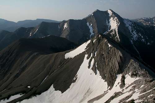
 Teton Peak from the saddlePoint 8779 from the saddle
So climb Point 8779 and then descend to a 7952’ saddle below Teton Peak. Hike, clamber, or scramble to the top and enjoy the solitude and the spectacular views.
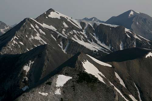
 Teton Peak from the descent of Point 8779
 Last part
The USGS Cave Mountain, Mount Wright, and Our Lake quads show the trail to Route Creek Pass. Unless you want to have all those maps to figure out where you are at any given time, it really is only necessary to use the Mount Wright quad if Teton Peak is your sole destination. That map shows the ridgeline from just north of Route Creek Pass to Teton Peak.
Getting There
About five miles north of Choteau, look for a west-heading road with signs indicating fishing and access to the Teton Pass Winter Sports Area. Take this road. 17 miles along, a road will branch left, cross the river, and become gravel. DO NOT take this road. Instead, stay straight (a sign will say you are on 144); the road will soon turn to gravel (well-maintained and probably passable even to a Corvette), enter the mountains, and take you through some gorgeous mountain scenery that almost no one outside Montana knows is there. The Cave Mountain Recreation Area is about 5.5 miles from the fork. Turn there and follow signs to the Middle Fork Teton (Route Creek Pass) Trailhead.
Red Tape
You are in bear country and one of the best places in the world to encounter grizzlies. Know proper techniques for food storage, and know how to behave if you encounter any bear. Carrying pepper spray is a good idea, but make sure you have tested it and know how to use it. Above all, don't do anything stupid to or around the bears. Don't become a statistic and/or one of those idiots responsible for yet another dead bear.
Camping and Lodging
There is a campground at Cave Mountain Recreation Area; the fee is $6 per night. There are water pumps there, but I have never stayed there and do not know if they work. You can also backpack in, sleep in your car at the trailhead, or use a dispersed camping site nearby (free, and fewer flies).
You could also stay at a motel in Choteau. It should take you 45-60 minutes to drive from there to the trailhead.
Some Summit Views
In this page's gallery there are several pictures showing summit views; these are my personal favorites.