
-
 8823 Hits
-
 84.82% Score
-
 19 Votes
|
|
Mountain/Rock |
|---|---|
|
|
48.01915°N / 112.89618°W |
|
|
Mountaineering, Scrambling |
|
|
Summer |
|
|
8461 ft / 2579 m |
|
|

Overview
Governments can designate land as wilderness, and it is good that they do, but a wilderness designation does not necessarily mean that the land is truly wild. Is man insignificant here? Has he left little or no mark? If something goes really wrong, are you in serious trouble? Is the original ecosystem, here meant as the ecosystem that existed before man arrived, intact. Do animals usually only seen in documentaries roam freely? Does one feel a connection to the heart of the wild world?
In most of Montana's Bob Marshall Wilderness, that answer is an emphatic "Yes!" America, while humans still exist, will never again be as wild as the remote mountain fastnesses of central Asia or the dark deeps of the Amazon Basin, but the vast roadless area that is "The Bob" is about as close as one can get, in the Lower 48, to the America that existed when the first white settlers arrived, and it is even a glimpse of the America that sprawled and thrived before the first humans arrived, period.
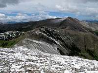
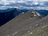
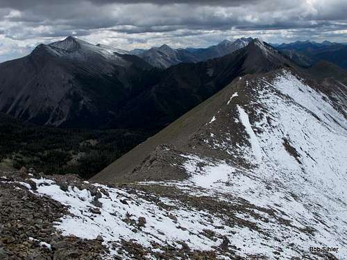
Atop Corrugate Ridge, which also happens to be situated on the great Continental Divide, sometimes called the Spine of America, one gets a taste of all that. About four miles long, the ridge has distinct peaks at its northern and southern ends (the southern peak is the higher one), and the views in all directions encompass a sea of mountains, the majority of which have no names. Some don't even have elevation points marked on a map. After leaving the trailhead, you are more likely to see a bear or a moose than you are another human. If you are really lucky, you will hear or even see a wolf. Within minutes, you cross an invisible line into the wild world. Knowing you are where a grizzly bear might come into your tent and maul you changes everything, but for true wilderness enthusiasts, that is a change for the better. The Great Bear must be respected and, yes, even feared, but for those who can admire it as well and feel the effect its presence has on the land, the world is so much more alive and filled with soul-changing potential.
So let's head out there.
Getting There
About four miles north of the Rocky Mountain Ranger Station in Choteau, look for a road indicating fishing and skiing access and heading west. Take this road. Nearly 17 miles along, a road will branch left, cross the river, and become gravel. DO NOT take this road. Instead, stay straight, and the road will soon turn to gravel (well-maintained and probably passable even to a Corvette), enter the mountains, and take you through some gorgeous mountain scenery that almost no one outside Montana knows is there. About 20 miles from the fork mentioned, the road crosses the North Fork Teton River and ends at a place called the West Fork Cabin Complex. There is ample parking on the other side of the river. The trail you want begins on the eastern side of the river and heads north.
Route Information
Easiest Route
Although this route is the easiest, it is also the longest. It is the best route to use if you are interested in the northern peak only or hitting both peaks from a base camp. Although it's possible for a very strong hiker to do both peaks in a day, you more likely will want to backpack in. Round-trip distance is 20-24 miles, and elevation gain, to attain both peaks, is about 3000'. Even though most of the route is a hike, there will be some Class 3 scrambling to attain the northern summit and probably some Class 3 to get to the southern one.
Start hiking up the gentle North Fork Teton River Trail. About a mile in, you cross the river (only knee-deep and easy in August 2012, but it could be dangerous earlier in the summer or in the spring), also officially crossing into the Bob Marshall Wilderness. At 2.6 mi. you cross it again, and at 2.7 mi, there is a junction with the Bruce Creek Trail. My copy of Erik Molvar's Hiking Montana's Bob Marshall Wilderness says the junction is poorly marked, but I found an old yet perfectly legible sign there in August 2012.
Turn left to follow Bruce Creek now. In just 0.1 mi you cross the North Fork yet again. For 2.7 pretty dull miles, you hike through dense forest, gradually gaining elevation, to a crossing of Bruce Creek (5.5 mi from the TH). Shortly after that the trail begins climbing more earnestly and views start opening up. Especially impressive the higher you get are Mount Wright to the south and the cliffs of Corrugate Ridge to the west.

7.3 miles from the TH, you cross the headwaters of Bruce Creek and start heading up some switchbacks to a 7730' pass crossing into the drainage of Nanny Creek (7730' is dense undergrowth in the Colorado Rockies but is above treeline up here). You reach that pass at 8.5 mi. From that pass, you can head west over some small summits and follow the ridge to the northern summit.
Instead, at the crossing of Bruce Creek's headwaters, leave the trail and follow the drainage and ultimately hike up to a saddle east of the northern summit. Then scramble (Class 3) to the crest of the ridge and hike the short remaining distance to the summit.
 |
 |
I have not been to the southern summit yet. From below, one can see a notch on the ridge that looks potentially difficult to negotiate. From the northern summit and the climb up it, though, it is easy to see that the route to the southern summit, which is about two miles from the northern one, is fairly easy to manage and should have nothing worse than Class 3 in spots.
 |
 |
Straight to the South Summit
In theory, after the crossing of Bruce Creek at 5.5 miles, you could leave the trail, work up a subsidiary drainage, and then clamber/scramble to the ridge's crest not far from the south summit. This would probably be the shortest way to the south summit, but not the easiest, for it appears you would have some nasty bushwhacking to deal with. I'd only recommend this route if you are focused on the south summit and nothing else.
Via Mount Wright
If you're in really good shape and want the south summit as a day trip, try this route. You will have to go over Mount Wright, descend to a saddle, and then climb directly to the south summit. One-way distance is about 7 miles, but it entails a drop of about 1300' to the saddle and then a climb of almost 1000' to the summit. Total elevation gain for the day will be around 5500'. Please see the Wright page for more details about where to start.
 Wright, Corrugate, and the connecting ridge
Alternately, one could stay on the West Fork Trail instead of veering off for Wright, hike to Teton Pass, and then cross the bump just east of the pass and ascend the south summit that way. Such a route would be longer than going via Wright but would feature much less elevation gain.
Red Tape
Nothing official I know of. Read posted wilderness regulations.
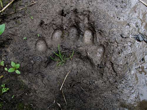
Remember, though, that you are in bear country and prime grizzly habitat. Know proper techniques for food storage, and know how to behave if you encounter any bear. Carrying pepper spray is a good idea, but make sure you have tested it and know how to use it. Above all, don't do anything stupid to or around the bears. Don't become a statistic and/or one of those idiots responsible for yet another dead bear.
Camping
Almost anyone doing this climb is going to backpack in, but if you must go for it in a day, there is a campground about fifteen miles back along the way (Cave Mountain Recreation Area), and there are numerous opportunities for dispersed camping, including at the road's end.
You could also stay at a motel in Choteau. It should take you 60-90 minutes to drive from there to the trailhead.