
-
 5608 Hits
-
 82.48% Score
-
 15 Votes
|
|
Mountain/Rock |
|---|---|
|
|
15.24808°S / 72.80914°W |
|
|
La Union |
|
|
Hiking, Mountaineering |
|
|
Spring, Summer, Fall, Winter |
|
|
16924 ft / 5158 m |
|
|
Overview
 Sunset - Moonrise
 Ridge to Cerro Lucmani
Huambo Crater is an extinct volcano located on the side of Cotahuasi Canyon, just above the village of Cotahuasi. It is open on the west side looking down into the canyon, and on the rim on east side is Cerro Lucmani, which looks like the point on the crown that the crater forms. To the north, separated by a narrow ridge, is another open crater, similar but smaller and without a peak on its rim. Beyond Cerro Lucmani on the high plain is Cerro Saraccoto, which is shown as 5,209 meters (17,090') on the map.
Although not a high mountain by Andean standards, Lucmani makes a great training hike for the 6,000 meter peaks in the area. Also if you start hiking from Cotahuasi, there is an elevation gain of 8,124 feet, which makes it a serious day hike.
Climbing
 Nathan on a Crux Move on the Traverse
 Starting Across the Crater
 Jerry Reaching the High Plain, Solimana in the Background
 Summit View From the High Plain
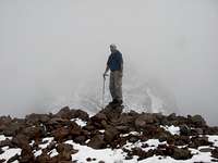 Jerry on the Summit, Cerro Saraccoto in the Background
 Looking For Our Route Down in the Fog
The most scenic route to the summit is to head up to the rim on the left side of the crater, follow the narrow ridge between the two craters to the high plain, and then follow along the rim of Huambo Crater to the top of Lucmani. There is a slight use path in some places here. Once on the high plain, it is an easy hike tecnically, with a final climb to the summit.
If you enjoy exposure and 4th class scrambling, go north and follow the ridge to where the rim starts and follow the rim all the way. If you want a shorter route with less scrambling, there is a large ridge farther to the right that is easy to follow up and reaches the ridge on the rim closer to the summit. It is a good idea to pick a descent route, and mark it on the way up in case the clouds come in before your return. There are many routes down the scree that make a quick descent.
To get the maximum elevation gain, start at the plaza in Cotahuasi and follow the street up towards the crater (you can't actually see Huambo but you can see the crater next to it on the left). After passing through the arch at the entrance to the city, the road turns right. There will be a building on your left, at the end of the building, there is a trail that goes to the left, following a small stream bed. After about 100 feet, follow the broad trail that climbs up to the right. The trail goes through the small village of Reparte and then follows the road around a curve before going off to the left to the village of Cachana. From Cachana the trail crosses the road two more times, as the road switchbacks up the canyon. At the second road crossing the large trail ends. Follow the road to the left for a short distance and there will be a small trail going up to the right, just where the road starts going along the canyon wall.
From here the trail goes up steeply, to the left of a high waterfalls, and then goes to the right to climb up to Huambo Crater. It is very difficult to follow the trail here as there isn't one main trail anymore, you just need to aim for the opening above the falls, using the best trail climbing up to the right. At one point you will come to an irrigation canal, follow this to the right and you will find a good trail going around to the crater, where you will finally be able to see the mountain peak on the rim of the crater. It is about a 11 to 14 hour hike from the village, and a 6 to 8 hour hike from the high trailhead on the road.
It is also possible to go across the floor of the crater, directly towards the peak, and climb up the steep scree covered wall of the crater to the summit. However the crater floor is not flat and there is no good trail here either, just a maze of animal trails going up and down the hills and gullies in the crater. The crater wall is much steeper near the peak as well, making for a more difficult climb.
Getting There, When to Climb
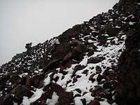 Getting Steeper, Snowing Harder
 The Summit in the Clouds
Cotahuasi is located about 379 Km (235 miles) from Arequipa, it normally takes 9 to 10 hours by private vehicle and 10 to 12 hours by bus, but can be more during the rainy season. Currently Reyna and Alex are the only buses serving Cotahuasi from Arequipa, see the Cotahuasi Canyon page for more details. There is limited combi service to a couple of villages above the canyon but it is not a daily schedule. Check in the village for the days and time. Also feel free to check with me for any additional information.
Lucmani can be climbed any time of the year, but during the rainy season (Dec. to March), there will be a high chance of clouds, rain and snow in the afternoon, including thunderstorms. During the rest of the year the weather should be dry but the days will be a little shorter as well, with about 12 hours of daylight during the shortest days. My favorite time is during the full moon, on the return hike reaching the bottom of the crater at dark and going back down to the village in the moonlight.
Red Tape, Camping
 Crossing a Small Stream Near the Trailhead
There are no restrictions, and no permits needed. The crater is grazing land for cattle and some sheep, and there are a few scattered houses, so be respectful of the fact that you are a visitor there. I'm not sure if it is private property or not but no one has ever objected to me hiking there.
You could camp many places in the crater if desired. There are a couple of nice streams flowing in the crater floor, but also lots of animals grazing, so the water should be treated.