
-
 17400 Hits
-
 88.61% Score
-
 27 Votes
|
|
Mountain/Rock |
|---|---|
|
|
15.72055°S / 71.86005°W |
|
|
Mountaineering |
|
|
Spring, Fall, Winter |
|
|
19767 ft / 6025 m |
|
|
Overview
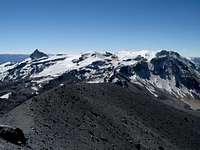 Hualca Hualca Summit From the Summit of Sabancaya
 Ampato and Sabancaya Summits From Hualca Hualca
Hualca Hualca at 6,025 meters - 19,767 feet, is the largest of the three mountains that make up the Ampato group, but Ampato is higher at 6,288 meters - 20,630 feet. The third member of the group is Volcán Sabancaya, 5,976 meters -19,606 feet. They are located in the Andes of southern Peru, about 60 miles northwest of Arequipa and are in the Cordillera Occidental. According to Jill Neate's book, “Mountaineering in the Andes”, both Ampato and Sabancaya had their first modern ascents in 1966, but no mention is made of Hualca Hualca. It has a large uneven summit plateau area with many small sub peaks on it, including one impressive rock tower.
 Coropuna and Solimana From Hualca Hualca
Getting There
 Park On the Right Here
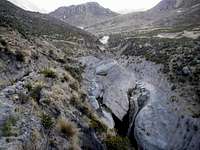 The Puff of Steam Is the Geyser
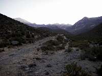
The easiest and closest approach to climb Hualca Hualca is from the Colca Canyon village of Pinchollo. From Arequipa take the road to Chivay until you just enter the city, at the police check station. Turn left and go to Pinchollo, which is towards Cabanaconde. The road starts out as pavement but soon turns into gravel at Yanque. Go a little past Pinchollo, just outside of the village there is a sign on the left for a geyser. Follow this road (it's very rough; high clearance vehicle recommended but may not be necessary if you are very careful) for about 6.4 Km, which is a couple of kilometers before the geyser. At this point there is a large and deep gully in the middle of the road making it impassable (at about 13,600 ft.). Just before here is a flat, wider spot along the road where you can park.
The Route
 Cross This About 5 Minutes Before the End of the Road
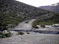 Don't Go This Way
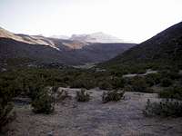 Go This Way, Up the Valley
 Going Up the Ridge
 On the Way UP
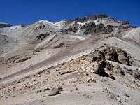 Near the Top of the Ridge
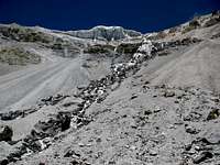 Looking Up To the Glacier
 On the Ridge To the Summit
There is some confusion about which peak is the actual summit. I was told it was the center peak. From the center peak, both the left and the right peaks look higher. We went on to the peak on the left (as viewed on the climb up) and it was higher than the center peak. By that time it was too far and too late to go back and check the peak on the right.
We came down the loose sand between the center and left peaks. There were some places with hard snow or ice under the sand which made the steep part of the descent sketchy at times. Below the sand we followed the valley around to the right of the ridge that we went up. I was told that you could also descend the sand on the other side of the center peak but we did not check that out. From the camping area, the descent is the same as the ascent.
Lodging and Camping
 Treat the Water!
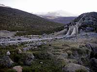
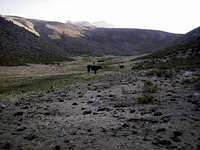
There is limited lodging in Pinchollo, I think there was a hostel on the plaza, but we didn't stop to look at it. You could camp at the end of the drivable road, at the parking area (it is not a parking lot, just a flat spot where you can pull off the road), but it's better to camp higher if you want to summit and return to the vehicle in one day. From the ridge at the top of the broad valley, look towards the ridge where the route starts, on the other side of a bowl. At about the same level you are at, is a rocky area with a couple of rock walls, at about 15,500 feet. There is also a stream near here which has clean (not muddy like the earlier canal) water. There are lots of animals grazing in the area, so as always in Peru, treat or boil the water. This is also a good place to leave your extra gear during the summit climb.
Cautions
 Watch Out For Water Holes!
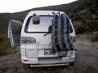 The Guy Watching My Van Gathered This Bag of Dung For Fuel
It is always a bit of a risk to leave your vehicle unattended in Peru. Because the parking area is in an area where there are herders and shepherds, we hired a man from Pinchollo to stay with the car to watch it. We had to pay 50 soles, plus buy his food, which seemed about twice the price it should have been (The day labor rate is 20 soles plus food in Cotahuasi, but the Colca area is more touristy and expensive). The mountain is rarely climbed so don't expect anyone else to be there for information or help. There is no vehicle traffic on the road, probably only the rare climbing group. We left our tent and extra gear in a small rock enclosure at the camping area and covered it with brush and grass so it wasn't readily visible from a distance.
Ice axe and crampons are recommended. On the climb up to the summit plateau, what looked like nice sand was a thin layer of sand over ice or hard snow, and very slippery. Once we reached the rim of the summit plateau there were lots of penitentes, When we were there in November, the low spots between the penitentes looked like solid ice, but in many places it was just a thin layer of ice over water filled holes. I doubt that the holes were deep but it would be very easy to soak your feet if your boots were not waterproof, or if the holes are deeper than boot height.
When to Climb
 Hualca Hualca In November, Looking From the Crater On Sabancaya
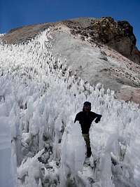 Penitentes On the Summit Ridge
Most of the peaks in the Arequipa area can be climbed any time of the year, however December through March is the rainy season so you need to be prepared for stormy weather. The days often start out nice and sunny but by early afternoon the clouds can cover the mountain, and bring rain, lightning and thunder; and snow above 16,000 or 17,000 feet. There could also be days or even a week at a time with clear weather; it is very variable. From April to July the days should be nice but the nights will be cold. There will also be more snow on the mountain, which may make climbing easier. From August to November should also be sunny weather and the nights will be getting warmer. The snow will also be melting and the penitentes will be getting worse, but they are only on the summit plateau area.