
|
|
Route |
|---|---|
|
|
34.80570°N / 111.76637°W |
|
|
Hiking |
|
|
Spring, Summer, Fall, Winter |
|
|
Less than two hours |
|
|
Hike |
|
|
Overview
Note: This is a page about the trail that goes around Courthouse Butte and Bell Rock. If you are interested in rock climbing opportunities, please see the linked pages.Courthouse Butte and Bell Rock are a couple of rocky formations that rise to the north of Oak Creek Village, AZ. With an elevation of 5451 ft, Courthouse Butte is a small flat-top mesa that rises 1000 ft above its base creating a continuous wall under the rim of the mesa. The 4919 ft Bell Rock is a rocky tower that sits to the west of Courthouse Butte.
A 3.5 mile loop trail goes around Courthouse Butte and Bell Rock. For longer day trips, the loop can be combined with many other trails that branch off of it.
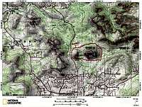 Map |
Getting There
From the intersection of Route 89A and 179 in Sedona (The “Y”), drive 6 miles south on Route 179 until you see a “Scenic View” sign on the left (east) side of the road. Park in the provided area and look for trail signs.Route Description
The loop trail is around 3.5 miles long.At the trailhead, you will be standing to the northwest of Bell Rock. This description takes you on a counter clockwise loop. The first part of the loop is a section of the Bell Rock Pathway. Do not confuse this with the Bell Rock Trail.
 Bell Rock, northwest face |
Get on the Bell Rock Pathway and head south on the west side of Bell Rock. In this section you will hear highway noise from Route 179
 Bell Rock, W/NW face |  On Bell Rock Pathway |
You will now be directly to the west of Bell Rock.
 Bell Rock, west face |  On Bell Rock Pathway |
As you reach the southwestern corner of Bell Rock, you will see a sign for Courthouse Butte Loop. Turn left (east) onto this trail.
 Bell Rock, SW face |
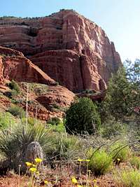
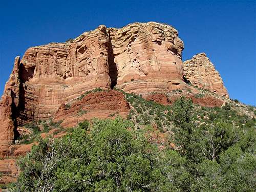
The western/southwestern face of Courthouse Butte comes into view.
 Courthouse Butte, SW face |
The trail then passes directly to the south of Courthouse Butte.
 South face of Courthouse Butte | 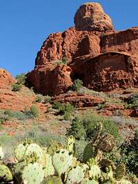 South face of Courthouse Butte |
 South face of Courthouse Butte | 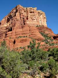 South face of Courthouse Butte |
At the southeastern corner of Courthouse Butte, you will reach a dry wash. The trail turns left and heads north along the dry wash.
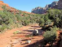 Dry Wash |
The east face of Courthouse Butte is now well visible.
 East face of Courthouse Butte |
As you head north, keep your eyes open for Muffin Rock (a.k.a. Spaceship Rock).
 Muffin Rock |
Once you reach the northeastern corner of Courthouse Butte, the trail turns left and heads west.
 NE face of Courthouse Butte |
You can now see Capitol Butte and Cathedral Rock in the distance.
 Capitol Butte |  Cathedral Rock |
The northeastern face of Bell Rock and the north face of Courthouse Butte now come into view.
 Northeast face of Bell Rock |
 North face of Courthouse Butte |
Follow the trail west to get back to the starting point at the parking area.
Essential Gear
Hiking equipment.Weather
See the forecast for the town of Sedona, AZ.Red Tape
You will need a Red Rock Parking Pass. See the link below:http://www.redrockcountry.org/passes-and-permits/where-to-purchase.shtml