
|
|
Route |
|---|---|
|
|
34.82972°N / 111.75467°W |
|
|
Hiking |
|
|
Spring, Summer, Fall, Winter |
|
|
Half a day |
|
|
Overview
A network of trails runs along the outer edges of the city of Sedona. These trails are far enough from the city to provide the hiker with a wilderness experience.The trails described in this page sit to the southeast of Sedona. I have arbitrarily lumped them together in a single page. They can be combined with other nearby trails that share a trailhead to create much longer day hikes (Margs Draw to the north and Courthouse loop to the south).
 Map |
Getting There
Courthouse Butte Trailhead:From the intersection of Route 89A and 179 in Sedona (The “Y”), drive 8 miles south on Route 179 until you see a “Scenic View” sign on the left (east) side of the road. Park in the provided area and look for trail signs.
Morgan Road Trailhead
Common to Margs Draw and Broken Arrow Trails. From the intersection of Routes 89A and 179 in Sedona (The “Y”), drive 1.4 miles south and turn left onto Morgan Road. Go a short distance to the end of the road.
Llama Trail
Llama Trail is 2.5 miles long (plus less than half a mile on Courthouse Loop Trail)At the Courthouse/Bell Rock Loop Trailhead, head east and follow the loop on the north side of Bell Rock. You will soon reach the junction with Llama Trail (after the junction with Bell Rock Pathway).
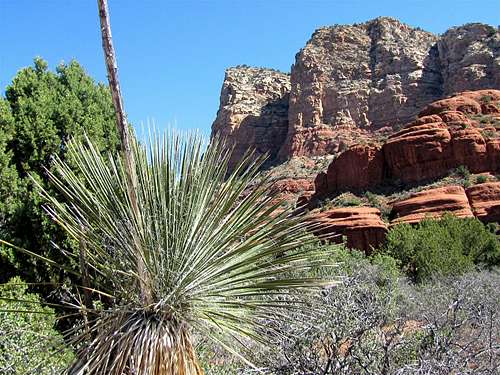
Llama Trail heads east toward a series of walls below Lee Mountain. The Twin Buttes will be visible to the north.
 Twin Buttes | 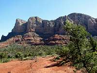 Looking East |  Looking East |
The trail then makes a turn and heads north at the base of the mentioned wall.
 Wall, looking east |
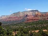
You will have good views of Cathedral Rock to the distant west.
 Cathedral Rock |
Twin Buttes will be visible to the north.
 Twin Buttes |
You can look south to see Courthouse Butte and Bell Rock. You will then reach the junction with Little Horse Trail.
 Courthouse Butte Buttes |  Looking East |
Little Horse Trail
Little Horse Trail is 2 miles long. This is a description of the 1 mile section of the trail between Llama Trail Junction and Chicken Point (where Broken Arrow Trail starts).You will see two impressive spires to the east of the eastern Twin Butte.
 Spires above Chicken Point | |
 Spires | 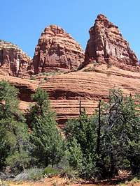 Spires |
The trail goes up to a saddle Known as Chicken Point at the base of the mentioned spires.
 Near Chicken Point | 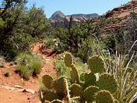 Near Chicken Point |
 Near Chicken Point | |
 Near Chicken Point |  Near Chicken Point |
At the saddle, the spires will be seen from a different angle. You are likely to see a large number of people brought to this spot by Jeep tour operators in Sedona.
 Chicken Point |
Broken Arrow Trail
Broken Arrow Trail is 1.5 miles long. For the most part it goes parallel with a Jeep Road. I missed the side trail to Submarine Rock. See the link at the bottom of the page.At Chicken Point, you can look south to get good views of Route 179.
 View south from Chicken Point |
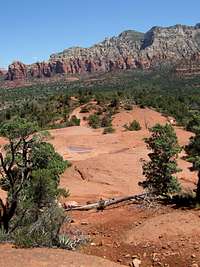
The trail heads north and slowly goes down in elevation to end at Morgan Road Trailhead. You will have superb views of the surrounding red rock country. Near the end of the trail, you will see a sink hole named Devils Dining Room.

|

|
|
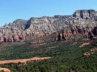
 Munds Mountain
 |
||
 Wilson Mountain
 |

|

|

|
||

|
|

|
Essential Gear
Hiking EquipmentWeather
See the forecast for the town of Sedona, AZ.Red Tape
You will need a Red Rock Parking Pass. See the link below:http://www.redrockcountry.org/passes-and-permits/where-to-purchase.shtml
External Links
Llama Trail: http://www.greatsedonahikes.com/llama/llama.html.Little Horse Trail: http://greatsedonahikes.com/littlebroken/littlebroken.html.
Broken Arrow Trail: http://www.greatsedonahikes.com/brokenarrow/brokenarrow.html.