
-
 10144 Hits
-
 88.61% Score
-
 27 Votes
|
|
Mountain/Rock |
|---|---|
|
|
43.99496°N / 114.6604°W |
|
|
Custer |
|
|
Hiking, Mountaineering, Scrambling, Skiing |
|
|
Summer, Fall |
|
|
10322 ft / 3146 m |
|
|
Overview
 Croesus Peak from the East.
Croesus Peak (pronunciation: CREE-sus) is an officially named peak. The peak has two summits. The summits are marked at 10322' and 10288' high and seperated by about 1/2 of a mile. There is not enough vertical relief between the 2 peaks to consider them seperate peaks. Despite being lower, the eastern point (Point 10288) is the location marked as the highpoint on the Horton Peak USGS topographic map. In addition to that distiction, Point 10288 is also adorned with a large wood pole and large cairn, while the higher Point 10322 has nothing more than a stack of rocks on its summit. The ridge between the 2 high points looks challenging, but if you hike just below the ridge crest on the south side of the mountain, things will remain class 2.
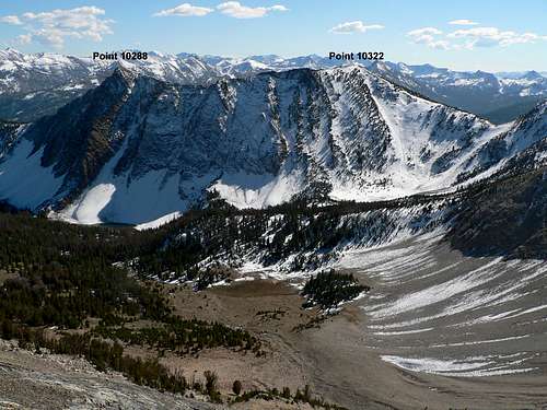 Croesus Peak's two main points...
The peak is located in the White Cloud mountains of Idaho. The peak does display the white sedimentary rock that gave this range its name, mostly on the east ridge around Point 10288. The peak is located at the southern terminus of the White Cloud range on a high, horseshoe shaped ridge that surrounds Washington Basin. This ridge is class 2 or 3 the entire way and makes for a good route that gets you access to 5 peaks. 3 of those peaks are officially named Washington Peak, Croesus Peak, and Bible Back Mountain and 2 that are unofficially named Ebony and Ivory peaks.
Croesus Peak has obstacle-free east and west ridges that make for non-technical ascent routes. It's south face is steep, but the terrain is open and it would likely allow for a class 2 ascent as well. The north side of the peak is anything but tame, as it is nearly vertical and drops over 1000' into Washington Basin. The north face is dark, steep, and filled with ice and snow for most of the year. From Washington Basin, Croesus Peak's north face is by far the most striking and imposing terrain that one can see. The steepest part of the face is just below Point 10288 and very visible when you walk the east ridge of the peak.
Name Origin
The peak was named in 1879 for the nearby Croesus Mine. One can only assume that mine was named after the ancient King Croesus of Lydia. Croesus was renowned for his wealth and in Greek and Persian cultures his name became a synonym for a wealthy man. In English, expressions such as "rich as Croesus" or "richer than Croesus" are used to indicate great wealth. Naming a mine after a king known for wealth seems sensical, hence my assumption that the name of the mine originates from his name.King Croesus:

Getting There
Germania Creek ApproachThe closest access to Croesus Peak would be from the south and Germania Creek. To get to the trailhead follow Highway 75 south for 26 miles from Stanley or north for 36 miles from Ketchum. Here turn east onto Pole Creek Road. Follow Pole Creek Road up and over Pole Creek summit, then down into Germania Creek. At about 12 miles from the highway you will reach the Three Cabins Creek trailhead. You can park here (there is plenty of room for dozens of cars) or continue on the 4WD road that leads into Washington Basin. From the 4WD road you could park where the road crosses Three Cabins Creek and turns east (.6 miles from the turnoff) or you could drive to where the road meets the south ridge of Bible Back Mountain (1.2 miles from the turnoff). From either stopping point you choose, climb the south slopes until you get on the east ridge and then follow that to the summit.
 Looking down the east ridge of Croesus Peak.
Other Approaches
The peak could also be climbed from the west and connecting ridge with Washington Peak or from the Champion Lakes. A group of my hiking friends actually completed a traverse around the high ridge surround Washington Basin, read about that here.
Red Tape
No trailhead parking permit is required, nor are there any useage fees for the area. Respect the historic value of the mining structures in the area. Also, be sure to watch the mountain goats from a distance and don't let your pets chase after them.Camping
Free camping opportunites are available all along the Pole Creek/Germania access road, including in an area about 1/4 of a mile before the trailhead. None of these are official sites, but camping in them is legal. The campsites just won't have tables, running water, and bathrooms.External Links
Mountain ConditionsBelow are some good starting points for finding current conditions in the area:
Sawtooth National Forest - NF Current Conditions.
NOAA Pinpoint Forecast – Weather
Idaho Outdoors Forum – Message board monitored by many local climbers.
When to Climb
This is an area that receives a lot of snow and the approach road is high by Idaho standards. So the climbing season in the White Clouds typically doesn't start until early July until October.Technical Climbing
I have not heard of any technical climbing on Croesus Peak. Looking from above at the steep cliffs dropping down the north side of the mountain, I am sure there would be several lines that would make for exciting technical snow/ice climbs. Just because there is not any information on technical climbs of the north face doesn't mean they haven't been attempted. Nor does it mean there aren't any good lines. However, this is Idaho and news travels slow here, beta is hard to come by, people don't always share in their feats, and there are a lot of peaks but not a lot of people. Potential technical routes may be found on the north face of the peak.