
-
 11859 Hits
-
 89.97% Score
-
 31 Votes
|
|
Mountain/Rock |
|---|---|
|
|
44.01770°N / 114.6532°W |
|
|
Custer |
|
|
Hiking, Scrambling |
|
|
Spring, Summer, Fall |
|
|
10514 ft / 3205 m |
|
|
 Ivory and Ebony
Overview
Ebony and Ivory, are two peaks who live together in perfect harmony in central Idaho’s White Cloud Mountains. These two modest summits anchor the east end of the ridge that forms the northern boundary of Washington Basin. The area falls at the far southern reaches of the range, just across the Germania Creek drainage from the ruggedly beautiful Boulder Mountains. Scenic Washington Basin is a historic U-shaped area home to many mining remnants and remains of old cabins, some more than a century old. The area was first settled in 1879 by George Washington Blackman, a freed slave and early day minor who was obviously quite well known and liked based on the number of geographic features which still bear his name today ( Blackman Peak, Washington Peak, Washington Basin, etc).Unlike the number-one single, Ebony and Ivory Peaks have never gotten much airplay. In fact they almost always take the roll of back-up singers to other nearby attractions. Hikers come the to area to visit scenic alpine lakes or the more popular officially named peaks, but few take the time to explore the summits of Ebony and Ivory Peaks. What this means is that a traverse of these two peaks can be done in almost certain solitude. In fact the only life usually seen on this ridgeline are the mountain goats that are known to frequent the slopes.
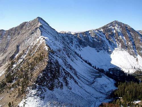
 Ivory and Ebony from the north.
 Ebony above Phyllis Lake
Peak 10514’ (Ebony Peak)
This summit seems out of place in the usually pale White Cloud Mountains. In fact it is probably the darkest colored peak in the entire range. It is composed of a dark sedimentary rock which is pretty uncharacteristic of the area and is pretty much limited to this peak.The peak is located near the middle of the crest north of Washington Basin, with Class 2 ridgelines to the east and west of the summit. It’s dark southern slopes fall gradually to the floor of Washington Basin below. Probably the most impressive view of this peak is from Phyllis Lake, where its rugged north side can be seen rising 1300 feet into the sky.
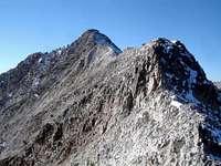 Ivory Peak North Ridge
Peak 10408’ (Ivory Peak)
East of Ebony Peak, the crest terminates at Ivory Peak. The summit is a typical “White Cloud Peak” composed of a type of pale limestone that is prevalent on the upper slopes of many mountains in the range. The summit is reachable by an easy Class 2 traverse from Ebony Peak, or via the south ridge from Washington Basin (also Class 2). However, the most enjoyable avenue to the summit is the north ridge. This route involves about 750 feet of sustained Class 3 scrambling in a half mile from the saddle east of Phyllis Lake.Name Disclaimer
The names "Ebony" and "Ivory" used for these two peaks are not widely acknowledged titles, and are unofficial names at best. Like most of the peaks in the White Clouds and Idaho in general, these two mountains have no official names. However, with over 125 years having passed since the area was first settled, it is likely that they have had a number of other unofficial names over the years. If you've heard of any, please let me know.Getting There
There are a couple of trailhead choices, both of which have their perks. Each requires a high clearance vehicle to reach the start of the climb. Ebony Peak above Washington Basin
Washington Basin Approach
The drive in to reach this area is an adventure all on its own. To get there, follow Highway 75 for about 26 miles south from Stanley (36 miles north from Ketchum) to Pole Creek Road. Follow Pole Creek Road east, up and over Pole Creek summit, then down Germania Creek. At about 12 miles from the highway, you reach the Three Cabins Creek trailhead. You can park here if like, or follow a rough 4WD road another 2.5 miles up and into Washington Basin. Once here, you can make your way cross-country up the south ridge of Ivory Peak or the southern slopes of Ebony Peak to reach the ridge-top. Another option would be to follow the 4WD road another couple miles until it ends. From the road’s end, you can take the trail towards Champion Lakes to the saddle south of Washington Peak. From the saddle, follow goat trails on the ridge north to Washington Peak, and then continue east to Ebony and Ivory Peaks. Climbing Ivory's North Ridge
Phyllis Lake Approach
Follow Highway 75 for about 17 miles South from Stanley (45 miles north from Ketchum), then head east on the gravel Fourth of July Creek Road, and continue 10 miles to the Fourth of July Lake trailhead. You may want to park here, or else continue driving just past the trailhead until you meet the Phyllis Lake jeep trail heading south. From here it’s about a 2-mile hike to the lake, or else you can take your chances with the jeep trail that gets to within a quarter mile of the lake.From the Phyllis Lake, follow game trails east for a half a mile or so to the saddle at the base of Ivory Peak. Here is where the fun begins. Start out on the east side of the ridge for the first half of the climb, and then regain the top of the ridge for the remaining distance. Once at Ivory’s summit, it’s an easy traverse west to Ebony. To get back down, descending a scree chute back to Phyllis Lake may be an option (scout this out from the lake prior to beginning the climb), but it’s probably safest to return the way you came.
Ebony Peak also has a couple of gullies on the north side of the peak that could make for fun early season snow climbs from Phyllis Lake.
Camping
Camping opportunities are abundant in the area. Washington Basin has a number of campsites, all unimproved. The Fourth of July trailhead has potable water and outhouses available. Or if you prefer to backpack in closer to the peaks, great campsites can be made near Phyllis Lake.Red Tape
There aren't any permits or parking passes needed, so no red tape to speak of. Just respect the historic value of the structures in Washington Basin and beware of falling snags in the Fourth of July area, leftover from the 2005 forest fire. Please tread lightly in general.When To Climb
The summer climbing season in the White Clouds is typically from middle July until the snow flies in October. A snow climb may be feasible earlier in the year on the north side of Ebony Peak, but the approach could be significantly longer depending on spring road conditions to the Fourth of July Creek trailhead.Mountain Conditions
Below are some good staring points for finding current conditions in the area:Sawtooth National Forest - NF Current Conditions.
NOAA Pinpoint Forecast – Weather
Idaho Outdoors Forum – Message board monitored by many local climbers.
External Links
- MountainVisions.com Panorama from the south ridge of Ivory Peak - The summit of Ivory Peak is above the guy with the tripod and hat. Pan to the left to see Ebony Peak, then farther to the left to see Washington Basin below. The hulking summit you see when the page first opens is Castle Peak.
- MountainVisions.com Panorama from Point 10500’, West of Ebony Peak - Ebony Peaks is visible above and left from the Mountain Goat. Ivory Peak can be seen in the distance, but is pretty overshadowed by Castle Peak directly behind it.
- MountainVisions.com Panorama from Washington Basin - This one is taken from down in Washington Basin, near the base of Ebony Peak. Ivory’s summit is just visible if you pan to the left. Pan further to see the southern slopes of Ebony Peak.
- IdahoSummits.com Trip Report – Details on a 6 peak Washington Basin traverse, including Ebony and Ivory Peaks.
- Ebony & Ivory, by Paul McCartney and Stevie Wonder – Because there’s no doubt you’ve been missing this 1982 chart topper.