

-
 18579 Hits
-
 79.77% Score
-
 11 Votes
|
|
Mountain/Rock |
|---|---|
|
|
43.96580°N / 114.7475°W |
|
|
9896 ft / 3016 m |
|
|
Overview
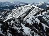
Horton Peak sits near the head of the Salmon River, the longest undamned river in the lower 48, looking out across the magnificent Sawtooth Valley. Horton Peak belongs to the elusive and rarely visited White Cloud Mountains. It sits at the far southwestern portion of the range and offers an excellent view of the range as well as the majestic Sawtooth across the valley.

Because of its location amongst this serene setting, Horton Peak itself is not impressive whatsoever. Its summit is tree covered even well above 9,500'. There are no cliffs or objects that make it an interesting place to climb. In fact, some who drive through the area think this peak is merely a foothill with little more to offer.
Don't get me wrong here. Yes, the mountain itself isnt impressive but the views alone are worth the 2.5 miles trek to the summit where more than 8 alpine lakes can be viewed.
Horton Peak forms a highpoint along a ridge just west of Sawtooth City that has 6 different points that rise above 9,000'. Compared to other areas in the White Cloud Mountains, Horton Peak sees quite a bit of traffic because of its accessibility.
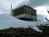
On the summit, one is greeted with an old fire-lookout, which may startle some who aren'e aware of it, that is now closed to the public.
 |  |  |  |
Getting There
To access Horton Peak from Ketchum, Idaho, drive north of town on Highway 75. Go up and over Galena Summit into the Sawtooth Valley.
Shortly before reaching Sawtooth City, or Smiley Creek as the locals call it, Pole Creek Road will leave the highway heading east toward the White Clouds. This road is well marked and not easily missed.
Continue on this well worn dirt for about 2.5 miles and keep in mind the open-range law that is in effect. Here you will come to a junction with Valley Road. Take the left fork, which is Valley Road. You will now find yourself paralelling the long ridgeline that Horton Peak is located on. After 6.3 miles, more or less, a brown sign that says "Horton Peak Lookout, 3 Miles" will be on the right side of the road facing the other direction.
Take this hard right turn and begin backtracking on the Taylor Creek Road. Although not terribly rough, a high clearance vehicle will be needed for this section of the drive.
Follow this road .75 miles until it ends at the Horton Peak Lookout Trailhead.
 |
West Ridge
This relatively mellow trail begins on long switchbacks in a mix of sage and aspen groves. It then slowly meanders up the west ridge leaving the valley floor behind weaving in and out of thick evergreen forests.
After two miles of moderate steepness and occasional switchbacks, the terrain becomes more alpine with scattered shale and White Bark Pine Trees. One last series of steeper switchbacks will lead you to the summit and the rust lookout.
 |  |
Red Tape
No red tape or permits required to access Horton Peak trailhead or the peak.
When To Climb
The West Ridge Route, for the most part, remains on the south side of the west ridge, therefore usually allowing a snow-free climb as early as June in some years.
A winter ascent would be a difficult, but not impossible. The Pole Creek Road is closed because of snowfall during off-season months. An ascent would include avalanche danger, and a 2 miles trek across the Sawtooth Valley to access the base.
Camping
Car camping would be ideal for the trailhead as well as some pullouts along Pole Creek Road.
There is only one major campground in the area. Smiley Creek Lodge includes, cafe, small grocery store, teepees for went, as well as other usual amenities.
Mountain Conditions
Hortn Peak is mostly baron and windswept. It is very isolated and subject to extreme weather conditions.
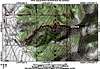
I have found a weather observation named Horton Peak, however, the elevation on the web page is incorrect so the exact location of this RAWS site is in question.
 |