
|
|
Route |
|---|---|
|
|
39.97392°N / 105.28859°W |
|
|
Trad Climbing |
|
|
Fall, Winter |
|
|
Half a day |
|
|
5.6 (YDS) |
|
|
3 |
|
|
II |
|
|
Overview
Many rocks on Dinosaur Mountain have colorful names. Der Zerkle is no exception. Zerkle should be a corruption of Zirkel, which is German for compasses. I've seen the formation from several angles, but the connection to the compasses has eluded me so far.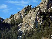 From the east
Der Zerkle belongs to the first and easternmost of the four main strata of the Fountain formation that make up on Dinosaur Mountain. It is easily spotted from the Walter Orr Robert trail, because of the three summits that look like three fingers. Thanks to the vicinity to the trailhead, Der Zerkle is the ideal destination for a short outing. Several routes exist on the faces of this formation. Both routes on the east face, the one described in this page and the one on the north edge of the face, are classic Flatiron slab routes. The west face, with its huecos, has several sport and trad routes in the 5.7-5.11 range. The north face provides the easiest way to the summit, and even the south face has a couple of routes.
 From the south
Der Zerkle is home to Fringed Myotis Bats in spring and summer. During that period, it is partially closed to climbing. Check this page for the details. In particular, the East Face Left route is usually off limits from April 1st to September 1st.
Getting There
From the NCAR parking lot, follow the Walter Orr Roberts trail to the intersection with the Mesa Trail, continue past the intersection on the popular Mallory Cave Trail.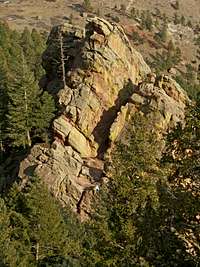 From above
The trail heads mostly south until the base of the east face of Dinosaur Rock and then rises with a series of switchbacks between Dinosaur Rock to the south and Der Zerkle to the north.
The low point of Der Zerkle, where the East Face Left route starts, is a few yards from the Mallory Cave Trail. If you miss it, you will soon run into a "climbing access" sign. Leave the trail there, turn right and contour the rock down to the base of the east face.
Route Description
The route can be climbed in three pitches with a 60 m rope. Der Zerkle is characterized by a overhanging band that cuts across the whole east face at about mid height. Above the overhang, the rock splits into three fingers, the middle of which is the summit. The alcove
P1: From the lowest point of the east face, climb the left side for almost 60 meters to a large alcove under the overhang. According to Roach, the left edge of the face is around 5.2. We stayed closer to the center and climbed some 5.6 slabs.
 In the tunnel
P2: From the alcove, enter the cave/tunnel. The rock is very crumbly at the entrance, but gets better as one climbs up and left. There is an old bolt in the tunnel, which you may want to double up. Once out of the cave, head up and right, aiming for the gully between the middle and right fingers. Belay at the top of the gully. This pitch is also close to 60 m. The tunnel is 5.6 and the rest is easier. Carrying a pack on this route is not recommended, because the tunnel is rather narrow, especially toward the exit.
 Stemming
P3: A short, easy pitch along a ramp takes you to the summit. The difficulties are around 5.2. Short as this pitch may be, I'm not sure a 70 m rope would allow one to reach the summit from the base in two pitches.
Descent
There are two bolts on the summit from which a single-rope rappel puts you on easy terrain. The start of the rappel is rather awkward. From the base of the rappel, scramble north up easy rocks and then turn left and descend around the formation back to your packs.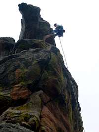 The rappel