
-
 20696 Hits
-
 90.48% Score
-
 32 Votes
|
|
Mountain/Rock |
|---|---|
|
|
40.65811°N / 111.59534°W |
|
|
Salt Lake. |
|
|
Hiking, Skiing |
|
|
Spring, Summer, Fall, Winter |
|
|
9990 ft / 3045 m |
|
|
Overview.
Desolation Peak is one of several peaks along the Park City Ridge which is bordered by Big Cottonwood Canyon to the south, the Park City area to the north east, and Mill Creek Canyon to the north west. This peak see's its fair share of different outdoor enthusiasts depending on the season. Primarily the most popular aspect of the peak is the ski terrain it offers during the winter season. The summer and fall seasons are times when the mountain is crossed by hikers, trail runners and mountain bikes as the Great Western Trail crosses it's lower west flanks. The Great Western Trail encompasses the majority of the Park City Ridgeline, offering exits along the way into Mill Creek and Big Cottonwood Canyons.Though not officially named, the peak takes it's name from Desolation Lake which is at it's western base. The interesting thing about the lake is that it has no actual flowing surface outlet, the water drops below into the water table and on down the drainage underground. One of the more common names for the peak is "Peak 9,990" or "Ninety Nine 90" as it is labeled on The Canyons Resort map, which borders the peak and ridge area to the north and east.
Views from this peak are extensive of the surrounding Central Wasatch Range and beyond. At just 10 feet under 10,000, it is one of the higher peaks located on the Park City Ridge giving a great vantage point. Silver Peak is the only higher summit in the direct vicinity, at 16 feet higher in altitude and less than half a mile to the south.
 Desolation Lake
 Desolation Peak's south ridge
 Desolation Peak's north ridge approach during winter
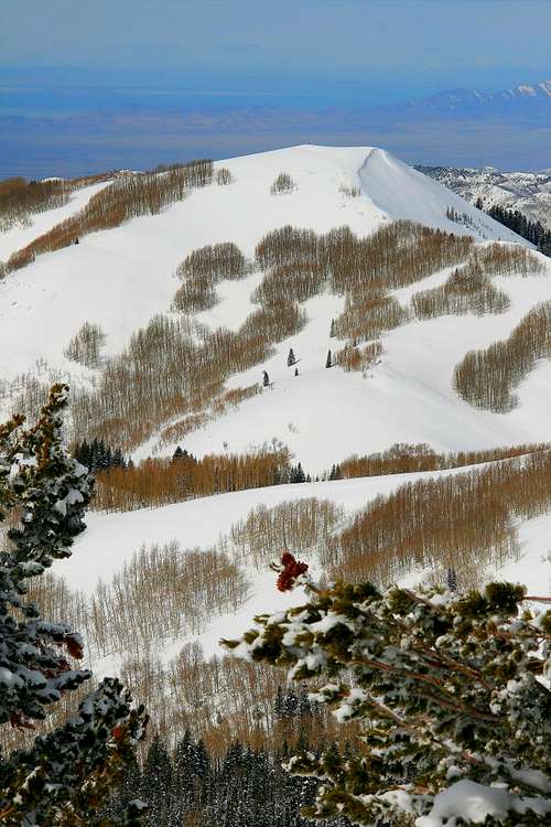 View from the ridge area west at Little Water Peak
 Desolation Peak's west ridge line above upper Mill D North Fork
 A view south west from the summit area
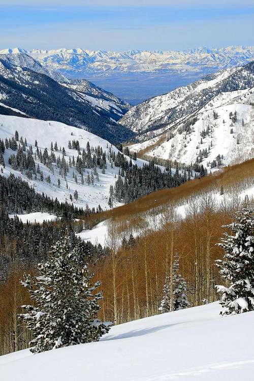 Looking west from the summit area down Big Cottonwood Canyon
Getting There.
Desolation Lake and the peak are primarily reached from the Mill D North Fork Trailhead in Big Cottonwood Canyon. From Wasatch Boulevard in Salt Lake, drive 9.6 miles east up Big Cottonwood Canyon on highway 152. The trailhead parking area is easy to notice on the north side of the road, you'll know your there when you see a "Meeting of the Glaciers" sign explaining glacial activity in Big Cottonwood Canyon. There is also a lavatory on the south side of the road, and the turn off to Mill D South and plenty of parking on either side. Kessler Peak dominates the southern view from this point as well. WGS 84 GPS datum for this trailhead is approximately 40.39002 N, 111.38945 W, 7,280 feet.Occasionally throughout the winter season large snow storms will temporarily close access to Big Cottonwood Canyon. During and just after a larger storm be prepared for this issue.
Red Tape.
This area is part of a watershed which requires camping at least 200 feet away from lakes and streams. Pets are not allowed. Another thing to note is that the lower portion of Mill D North Fork has private cabins dotting the land, use and show respect for those properties and owners.During the summer season if you're anywhere on the Great Western Trail be prepared to share it with mountain bikes. Keep an eye out for those riders who may not be as attentive, to avoid having an accident.
During the winter season if venturing up be prepared to share the peak with skiers and snowboarders who make the short hike up from the lift, from The Canyons Resort on the mountains north east side. More often than not some of the Canyons patrons will ski down the west aspect of the peak, then make their way back up to the peak or ridge area.
During the fall season Mill D North Fork see's it share of bow hunters after the larger game in the area. Be alert during this season, you may notice someone above or below you on the trail quietly scoping out the terrain primarily for deer.
Camping.
The closest developed campground is The Spruces.The Spruces Campground sits at an altitude of 7100 feet, 9.4 miles from the entry sign for Big Cottonwood. It can get a little chilly even in the summertime. Featuring 97 individual sites and 9 group sites, this is a pretty big campground. The sites vary from close together little plots to spaced out plantations. About half of the sites are reservable. Small tributaries of the creek wander throughout the campground. Nearby hiking trails lead off to Donut Falls. Each individual site is $14.00 per vehicle, additional vehicles are $5.00.
------------------------------------------------------------
Back country camping is plentiful in the area if that's your niche. Remember the 200 foot rule from lakes/streams. The area near Desolation Lake in upper Mill D North Fork has several primitive style camping locations.
When to climb and gear.
This is an all season peak.Summer, Spring and Fall.
During these seasons the proper attire, weather pending is mainly all one will need. The summer season will get warm, plan of some sunscreen and plenty of water. Most footwear can be worn on the route up, nothing rugged will be needed. The area can get muddy during the early/mid spring season or just after a fresh storm, plan on dealing with that aspect accordingly. Also as mentioned in the Red Tape portion it would be wise to pack along some orange apparel during the fall hunting season though not absolutely needed as firearms are not used.
Winter.
This area is about as popular in winter as any other season, perhaps more so. Ski's or snowshoes will be needed, especially if heading off route as the area receives its share of snow accumulation. Proper winter attire will be needed as the weather can change at a moments notice.
The area does have some avalanche danger. Proper avalanche gear is highly recommended during these times. Be sure to check out the Utah Avalanche Center page here for current conditions on the mountain.
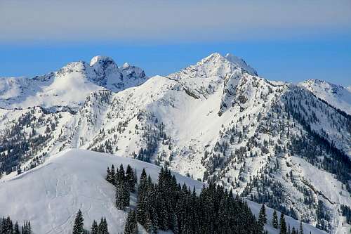 An interesting view of the Triple Traverse peaks from the summit area.
Route information.
There are several different approaches for this peak. The primary route as mentioned above is Mill D North Fork.Mill D North Fork:
One way mileage: 4 miles.
Elevation Gain: 2,710 feet.
Class I and II, depending on the approach.
Rough time needed round trip, depending on conditions: 4-8 hours.
The trail starts in the Reynolds Gulch area, then parallels south up the hillside to the east to Mill D. After about half a mile, the trail turns north into the drainage area. After three fourths of a mile, the trail branches either west to Dog Lake, or east to Desolation Lake. The sign here states the mileage to be 1.9 miles to Desolation Lake. After a short switchback from the sign a great view point to the south is reached, then a large meadow area. After the meadow area continue heading east to the lake. On the north side of the lake is where the Great Western Trail ascends to the flank of Desolation Peak. From anywhere reasonable along this portion of the trail a route can be made to the summit, roughly 200 vertical feet above the trail depending on the location.
Another approach to the peak is from Beartrap Fork, crossing over or under Silver Peak.
That route can be seen here.
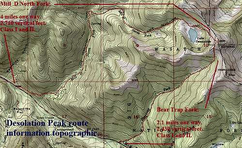 Desolation Peak Topographic, Mill D and Bear Trap routes.
Mountain weather.
The Central Wasatch weather conditions are constantly changing from one moment to another. This area is close in proximity to both Solitude and Brighton Ski Resorts. Please check the links below for the most current conditions weather wise before heading out.Solitude Weather link here.
Brighton Weather link here.
