
|
|
Mountain/Rock |
|---|---|
|
|
40.61330°N / 111.54003°W |
|
|
Summit County |
|
|
Hiking |
|
|
Spring, Summer, Fall, Winter |
|
|
9998 ft / 3047 m |
|
|
Overview
 Skiing Jupiter. Image by TyeDyeTwins
Jupiter Hill is a peak located almost directly south of Park City Utah. At 9998ft, it is is just shy of the 10,000ft mark. So bring a rock or two to the summit and eventually it will join the ranks of the Wasatch 10ers. Jupiter Hill is at the southern boundary of Park City Mountain Resort (PCMR). Although it is within the boundaries of PCMR, there are no ski lifts going to the top of this mountain, which is really nice. Another plus about this peak is its close proximity to Park City (UT).
Jupiter Hill is in the central portion of Central Wasatch Mountains along the Park City Ridge. This peak is easily accessed from its southern face while its eastern and western faces provide are alot steeper. The north face of this mountain can be accessed via the pioneer ridge which leads directly to the summit. There is a pole that marks the summit and also there is a mountain rescue hut about a hundred yards or so down from the summit. From the summit, you have excellent views of Clayton Peak, Big Cottonwood Canyon, Park City, PCMR, Deer Valley Resort, the Weber Watershed and much more.
Also, if your hiking this peak, you might want to think about hiking Clayton Peak, Peak 10, 420, and Tri-City Peak. They are all close to Jupiter Hill and would make a nice addition.
Routes
 Jupiter viewed from Park Mountain
 North Ridge
Jupiter Hill via Park City Ridge- From the turnout at the pass in-between Deer Valley Resort and Park City Resort (see "Getting There" for more information) , Jupiter Hill will about two miles west along Park City Ridge. Just follow the ridge and it will lead you directly to the peak.
Jupiter Hill via Guardsmen Pass- From the turnout, Tri-County Peak will be directly north of the turnout. Hike up to the saddle between Tri-County Peak and Jupiter Hill. From here, just follow the ridge line towards Jupiter Hill which will be just east from the saddle.
Aside from these two routes, you could access Jupiter Hill from its steep east face (class 3-4) or take it's northern ridge that leads towards Park City.
Red Tape
 East face of Jupiter Hill
The road through Guardsman Pass Road will not be plowed in the winter past Pine Canyon Road and right after Brighton Ski Resort, so that would make for a longer approach.
Also, since it is within bounds of PCMR, a lift pass would probably be necessary during the winter months.
There is LOTS of private property around and be sure to stay off or if you have to pass thru someone lands, try to spend as little time on it as possible.
All in all, this is a better summer hike versus a winter one unless of course you are staying at PCMR.
Click here for additional information.
No dogs are allowed in this area either. The reason being is that much of this area serves as a watershed to the Weber River.
Camping
 Ski hut below the summit
This is more of a day hike, so camping isn't really neccesary. Camping is a little tricky in this area. The reason why its a little tricky is that there is alot of private property that dots this whole area. If you are going to camp, be sure to not camp on any private land. Rumor has it that the land owners are not very forgiving, even to hikers. Anything that is not on private land is open to camping.
Getting There
From Park City (directions to Jupiter Hill via Park City Ridge)Head southeast on Park Ave/UT-224 toward Lame Dog and go 0.3 mi
Merge onto UT-248 and go 2.6 mi
Turn left at Deer Valley Dr/UT-224 and go 1.1 mi
At the traffic circle, take the 1st exit onto Marsac Ave/UT-224 Continue to follow UT-224 and go 3.6 mi
Turn left at Marsac Ave/UT-224 and go 75 ft
Turn left to stay on Marsac Ave/UT-224 Continue to follow UT-224 and go 2.1 mi
Slight right at Pine Canyon Rd/UT-152/UT-190 Continue to follow UT-152/UT-190 and go 0.8 mi
Arrive at: Guardsman Pass/UT-152/UT-190.
Also, it is possible to drive up Big Cottonwood Canyon to Brighton Ski Resort and up through Gaurdsman Pass from the opposite direction. However, That portion of the road is seasonal.
Big Cottonwood Canyon- Head east on Big Cottonwood Canyon Road(UT 152). Take a right on East Guardsmen Pass Road (UT 190). Keep following this road until you reach Guardmen pass. There is a turnout on the left side that can serve as parking for hiking this peak.
Mountain Biking
Also this area receives lots of mountain bike activity. Lots of trails provide opportunity for premier cross country, downhill and just plan mountain biking. During the summer, you will most likely see them out and about on the surrounding trails, so be aware of that. For more information about the local mountain biking, click HERE.History
 Old Truck
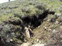 Old Mineshaft
This part of the Wasatch was famous for its silver mining. Most of the mining activities began in the early 1850's when Mormon settlers discovered it just in the hills behind Park City. As of today, there are still plenty of old and abandoned mine-shafts that dot the area. Park City was founded in 1872 as a mining town. Over the years, this town has changed from a small silver mining town into a world renown ski resort city. Aside from silver, lead and zinc were also mined from these mountains.
Interestingly, during this mining era, many of the evergreen trees were logged and much of the area was left barren by this. However, in the early 1900's, a restoration project was funded and many of the trees were restored.
Also, this area was considered prime hunting and trapping land by the native Ute Indians, trappers, and Mormon settlers.
External Links
Park City Mountain ResortUtah Avalanche Center
Avalanche Center
Wasatch-Cache National Forest
vanman798 - Feb 28, 2009 10:19 pm - Hasn't voted
Lat/LanHey, http://www.acme.com/mapper/ figures the Lat/Lan of Juptier Hill as 40.61340N / 111.54003W
Alex Wood - Feb 28, 2009 11:55 pm - Hasn't voted
Re: Lat/LanYeah, it was a little off, I fixed it. I also noticed that some of my other peaks are off as well, so ill fix those. Thanks! P.S. Did you get any pictures??
vanman798 - Mar 1, 2009 12:07 am - Hasn't voted
Re: Lat/LanI wish I would have had my camera with me, but I didn't.
Alex Wood - Feb 27, 2010 2:44 pm - Hasn't voted
Re: Lat/LanBummer!