
-
 3991 Hits
-
 80.06% Score
-
 12 Votes
|
|
Mountain/Rock |
|---|---|
|
|
49.18454°N / 7.75207°E |
|
|
837 ft / 255 m |
|
|
Overview
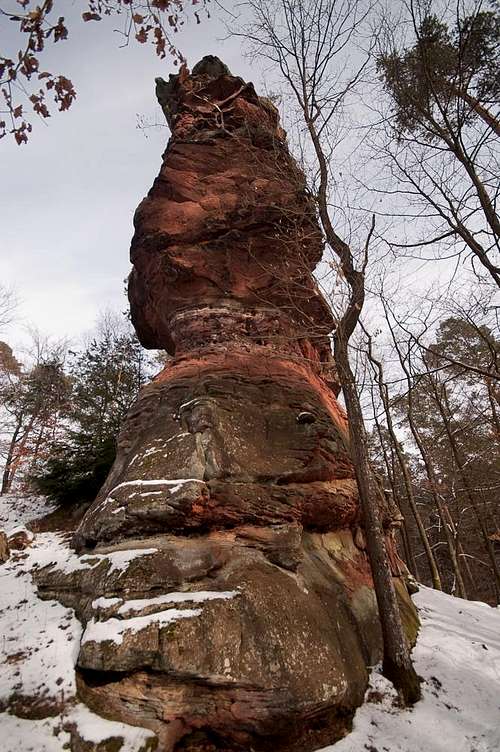 Dreikönigsfelsen western tower Dreikönigsfelsen western tower |
Die Heiligen Drei Könige - The Three Magi from the East - are the naming patrons of a three-towered rock formation which is located on Kleiner Hellen-Berg, a mountain between the village of Hinterweidenthal and the town of Dahn. Like many of the climbing rocks of the Südpfalz Climbing Region they are hidden inside the Pfälzerwald forest and barely visible from afar. On a winter day you stand a chance (see sig pic) to see their silhouettes through the trees but usually you'll have to know their position more or less exactly to get into their vicinity. There is a narrow, overgrown path which leads towards their base, however, so that - once the orientation problem set aside - access turns out surprisingly easy.
The towers are located in what is called Dahner Felsenland, the climbing centre of the Südpfalz Area which stretches from Bruchweiler across Dahn and Erfweiler to Hinterweidenthal. Thanks to more easily reachable "competition", the rocks are not overly popular so that they can serve as a substitute destination if nearby Teufelstisch, Heufels or Rabensteine are too crowded. Climbing routes vary through all grades of difficulties, starting with a grade 1 normal route and ending at the 9- route "König der Zwerge" through the overhanging west face.
 |  |  |  |
The lack in popularity resulted in late route establishment. While most major towers in the area were already climbed in the first two decades of the 20th century, Dreikönigsfelsen were discovered only in the 1960s. Hans Laub, together with different partners, established first routes in 1964 but kpt revisiting the crags all through 60s and 70s. Also, Südpfalz climbing guidebook author Udo Daigger established a couple of routes here in the late 60s.
 |  |  |  |
As the name indicates, Dreikönigsfelsen separate into three distinct towers which are separated by narrow cracks (bottom) and chimneys (top). The westernmost tower starts with a big roof right above the ground, only to follow up with a nicely structured but brittle upper west face. Quite differently the eastern tower has a rock solid vertical east face with only few structures. Several crack systems run through the formation, offering themselves as natural ascent routes. The normal route, though rated only grade 1 (hands needed while scrambling), winds through the north face of the central tower along ledges. Reaching the western or eastern towers the most scary of Südpfalz climbing techniques is needed: the jump across a chimney onto a small summit platform. Better put on the brakes before you jump too far...
Climbing routes on Dreikönigfelsen
 Dreikönigsfelsen eastern tower
The following table has a link to the tour database of the PK, where you can find the grades for the free routes plus additional information. Here is the link to the complete route database.
| Feature | Routes link | Summary |
| Dreikönigsfelsen | Dreikönigsfelsen | 10 routes with variations ranging from 1 - 9- |
Getting There
The Dreikönigsfelsen towers are located on a ridge between Hinterweidenthal and Dahn on Kleiner Hellenberg. There is a small parking lot on the west side of L427, the highway which connects Hinterweidenthal with Dahn, just across the road from the rocks.From Frankfurt
There are two possible routes which both take equally long- Via Ludwigshafen
- From Frankfurt take motorway A5 southward to Darmstadt.
- There change to A67 south.
- At Viernheimer Dreieck turn onto A6 west.
- Leave it at Frankenthaler Kreuz for A61 south.
- At Mutterstädter Kreuz take A65 south until you reach Landau.
- At Landau turn on B10 west.
- At Hinterweidental turn onto B427 south.
- After you leave Hintterweidenthal, before the intersection to Salzwoog, there is a small parking lot hidden to the right of the road.
- Cross the road from the parking lot and a hiking path will take you to the eastern base of the rocks.
- Via Kaiserslautern
- From Frankfurt take motorway A3 west
- At Mönchhofdreieck turn onto A67 south
- At Rüsselsheimer Dreieck take A60 west
- At Kreuz Mainz Süd take A63 south
- At Kreuz Kaiserslautern turn onto A6 west
- At Kreuz Landstuhl turn onto A62 south
- At Pirmasens turn onto B10 east
- At Hinterweidental take B427, then follow the instructions above
From Stuttgart
- Take motorway A8 to Karlsruhe
- At Karlsruher Dreieck turn north onto A5
- Take the next exit to head for A65
- At Kandel you can leave onto B427 which will lead you directly to Dahn. However the detour to Landau and B10 will take less time as the roads are better (three or four lanes).
- At Hinterweidental take B427, then follow the instructions above
Red Tape
The sandstone of Südpfalz forms lots of caves and overhangs. Though this makes it most interesting for climbers, two species of birds of prey compete for this habitat: the peregrine falcons and the eagle owls. Both are endangered and wherever there is a eagle owl pair found nesting in the sandstone the crag will immediately be closed. Generally this closure lasts from the beginning of each year through Aug. 1st. If breeding is not successful the closures will be cancelled even before that date. For a list of closures see the Closure List of PK. The Schillerfelsen are so close to the nearest houses of Dahn, that usually birds don't nest there. However, please adhere to "stop signs" if there are any.The use of magnesia is not allowed in the whole Südpfalz region. This is rather a directive or an arrangement than an outright law. Thus you probably will get away with using it but do so only when absolutely necessary. Magnesia closes the pores which you find in the sandstone and together they form a smooth surface which will get very slippery in wet conditions. The rule of thumb is to use magnesia in the highest difficulty sections and only extremely sparingly.
A list of guidelines can be found here (in German).
Accommodation
There are all kinds of accommodation to be found at Dahn: campgrounds, youth hostel, rooms and apartments:Dahn tourist information site
The closest campground is between Hinterweidenthal and Dahn at Neudahner Weiher just across B 247 from the crags.
Weather conditions
Maps & Books
Maps
As for maps there is a good overview map (1:50000) by Kompass Verlag but the best ones are the official topographic maps by the state government of Rheinland Pfalz, scaled 1:50000, 1:25000 and 1:5000. All official maps can be found on the web page of Landesvermessungsamt Rheinland Pfalz
1:50000
- Naturpark Pfälzer Wald
Kompass Map WK766
ISBN: 3-85491-523-3
- Pirmasens Süd<
LVA RLP Map L6910
ISBN: 3-89637-193-2
1:25000
- Dahn
LVA RLP Map 6812
ISBN: 3-89637-147-9
Books
There are a number of climbing guidebooks on the region of Südpfalz. The best ones, however, have been published privately and are sold only in selected bookshops of the region.
- Hiking
- Pfälzerwald
B. & J.-Th. Titz
Rother Verlag
ISBN: 3-7633-4268-0 - Klettern im Buntsandstein
U. Daigger, H.-J. Cron
Westpfälzische Verlagsdruckerei St. Ingbert
ISBN: 3-00-0155457-4
- Pfalz - Klettern im Buntsandstein des Pfälzer Felsenlands
J. Richter, S. Tittel
Panico Alpinverlag
ISBN: 978-3-936740-41-7
- Pfalz ++, Klettern im Buntsandstein
R. Burkard, P. Weinrich
Published privately
- Klettern im Naturpark Pfälzerwald
Naturfreunde Lambrecht
Published privately - Pfalz & Nordvogesen en bloc
A. Wenner, Y. Corby, I. Bald
Panico Verlag
ISBN: 3-936740-19-4
  Climbing Guidebook |
Climbing