
-
 3624 Hits
-
 81.18% Score
-
 13 Votes
|
|
Mountain/Rock |
|---|---|
|
|
49.13642°N / 7.81905°E |
|
|
Sport Climbing |
|
|
Summer, Fall, Winter |
|
|
1033 ft / 315 m |
|
|
Overview
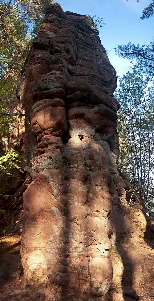 Hauptgipfel foresummit west face Hauptgipfel foresummit west face |
Named after an egg-shaped (=Ei) hole (=Loch) in the summit structure of its highest summit, the Eilöchelfelsenconsist of five sandstone towers, which run in west-easterly direction between the villages Busenberg, Schindhard and Reichenbach in the centre of the Südpfalz Climbing Area. This hole or rock window, however, can only be seen from the summits of the surrounding climbing formations like Strackfels or Eckfels. From all other directions it is hidden from view. From west to east the five formations are: Abschiedsfels, a rather unimportant roch, detached from the rest of the formation by 200m, Hauptgipfel, the highest main summit (the one with the window) which also has a lower fore summit, Reichenbacher Turm and Schindharder Turm, two towers which are connected by a lower ridge and Busenberger Turm, the easternmost tower with a uncomfortably overgrown base.
 |  |  |  |
All five towers were first climbed on June 14th 1908 by a team of Südpfalz pioneers, Friedrich Jung, August Bauer and Karl Petry, who later went on to establish some of the Südpfalz classic routes on other formations. Here on the Eilöchelfelsen their routes have become the normal routes, rated I or II, which are most often used for descending after climbing on of the towers along one of the more difficult other routes. Most ascent routes were established on Hauptgipfel and Busenberger Turm where you also can find the highest difficulties (7+ and 8 respectively). The masive south face of Hauptgipfel was already climbed in 1910 by a team consisting of three othe Südpfalz pioneers: Fritz Mann, Theo Mann and Jakob Otto together with August Prehl and Karl Schenk. Further routes had to wait until the 1950s and only the sport climbing era completed the list of routes in the late 1970s and 1980s.
 | 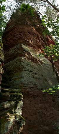 |  |  |
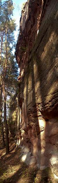
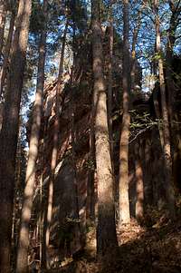
The five towers are well hidden underneath the canopy of the surrounding forest. While access is short and easy - there is a parking lot some 400m to the east of the formations on the road between Busenberg and Schndhard - the rocks are often overgrown with moss and lichen as the sun doesn't stand much of a chance to get through to reach the rock. This would make the towers perfect climbing destinations on hot summer days if it weren't for the ants, which each year decide to set up their heaps at the base of the rocks, mainly Busenberger Turm. The trees stand very close to the formation so that the upper regions are almost hidden from view.
Climbing Routes on Eilöchelfelsen
 |  |  |  |
The following table has a link to the tour database of the PK, where you can find the grades for the free routes plus additional information. Here is the link to the complete route database.
| Feature | Routes link | Summary |
| Eilöchelfelsen: Abschiedsfels | Abschiedsfels | 2 routes 1 and 2 |
| Eilöchelfelsen: Hauptgipfel | Main Summit | 9 routes with variations ranging from 3 - 7 |
| Eilöchelfelsen: Reichenbacher Turm | Reichenbacher Turm | 2 routes with variations 1 and 3 |
| Eilöchelfelsen: Schindharder Turm | Schindharder Turm | 6 routes with variations ranging from 2 - 5 |
| Eilöchelfelsen: Busenberger Turm | Main Summit | 9 routes with variations ranging from 1 - 8 |
Getting There
There is a parking lot at the road between Busenberg and Schindhard, about 500m to the east of the formation. It also serves nearby Strackfels and Eckfels. You can reach Busenberg as follows:From Frankfurt
There are two possible routes which both take equally long- Via Ludwigshafen
- From Frankfurt take motorway A5 southward to Darmstadt.
- There change to A67 south.
- At Viernheimer Dreieck turn onto A6 west. Leav
- e it at Frankenthaler Kreuz for A61 south.
- At Mutterstädter Kreuz take A65 south until you reach Landau.
- At Landau turn on B10 west.
- At Hinterweidental turn onto B427 south which will take you through Dahn to Busenberg
- Via Kaiserslautern
- From Frankfurt take motorway A3 west
- At Mönchhofdreieck turn onto A67 south
- At Rüsselsheimer Dreieck take A60 west
- At Kreuz Mainz Süd take A63 south
- At Kreuz Kaiserslautern turn onto A6 west
- At Kreuz Landstuhl turn onto A62 south
- At Pirmasens turn onto B10 east
- At Hinterweidental take B427 south to Busenberg
From Stuttgart
- Take motorway A8 to Karlsruhe
- At Karlsruher Dreieck turn north onto A5
- Tke the next exit to head for A65
- At Kandel you can leave onto B427 which will lead you directly to Busenberg.
Red Tape
The sandstone of Südpfalz forms lots of caves and overhangs. Though this makes it most interesting for climbers, two species of birds of prey compete for this habitat: the peregrine falcons and the eagle owls. Both are endangered and wherever there is a eagle owl pair found nesting in the sandstone the crag will immediately be closed. Generally this closure lasts from the beginning of each year through Aug. 1st. If breeding is not successful the closures will be canceled even before that date. For a list of closures see the Closure List of PK.The use of magnesia is not allowed in the whole Südpfalz region. This is rather a directive or an arrangement than an outright law. Thus you probably will get away with using it but do so only when absolutely necessary. Magnesia closes the pores which you find in the sandstone and together they form a smooth surface which will get very slippery in wet conditions. The rule of thumb is to use magnesia in the highest difficulty sections and only extremely sparingly.
A list of guidelines can be found here (in German).
Accommodation
In Busenberg you can find pensions, apartments and restaurants. Have a look at the official site for more info. There is a campground at Neudahner Weiher, north of Dahn, a second one west of Dahn. Both are about 10 km to the north-west of Busenberg. A third campground can be found at Bruchweiler-Bärenbach, about 7km to the south-west.Weather Conditions
Maps & Books
Maps
As for maps there is a good overview map (1:50000) by Kompass Verlag but the best ones are the official topographic maps by the state government of Rheinland Pfalz, scaled 1:50000, 1:25000 and 1:5000. All official maps can be found on the web page of Landesvermessungsamt Rheinland Pfalz
1:50000
- Naturpark Pfälzer Wald
Kompass Map WK766
ISBN: 3-85491-523-3
- Pirmasens Süd
LVA RLP Map L6910
ISBN: 3-89637-193-2
1:25000
- Dahn
LVA RLP Map 6812
ISBN: 3-89637-147-9
Books
There are a number of climbing guidebooks on the region of Südpfalz. The best ones, however, have been published privately and are sold only in selected bookshops of the region.
- Hiking
- Pfälzerwald
B. & J.-Th. Titz
Rother Verlag
ISBN: 3-7633-4268-0 - Klettern im Buntsandstein
U. Daigger, H.-J. Cron
Westpfälzische Verlagsdruckerei St. Ingbert
ISBN: 3-00-0155457-4
- Pfalz - Klettern im Buntsandstein des Pfälzer Felsenlands
J. Richter, S. Tittel
Panico Alpinverlag
ISBN: 978-3-936740-41-7
- Pfalz ++, Klettern im Buntsandstein
R. Burkard, P. Weinrich
Published privately
- Klettern im Naturpark Pfälzerwald
Naturfreunde Lambrecht
Published privately - Pfalz & Nordvogesen en bloc
A. Wenner, Y. Corby, I. Bald
Panico Verlag
ISBN: 3-936740-19-4
  Climbing Guidebook |
Climbing