|
|
Route |
|---|---|
|
|
40.38460°N / 111.636°W |
|
|
Mountaineering |
|
|
A long day |
|
|
Class 3, Possible Class 4 through "The Step" |
|
|
Approach
Everest Ridge is a local name that gains its meaning from an early 1990's Mt. Everest Expedition team from Utah. The team used this route in the winter for training.
Map by PellucidWombat.
You can approach this route from three directions. These directions are highlighted in RED on the map above. Starting from top to bottom:
1. Take Trail 56 in a 4WD from American Fork Canyon to Sagebrush Flat, near the top of Battle Creek Canyon.
2. Take Battle Creek up to the Big Baldy/Timpanogos Saddle.
3. Take Dry Canyon up to the Big Baldy/Timpanogos Saddle.
From each of these trailheads, you are trying to reach the saddle between Big Baldy and Timpanogos. The following are stats provided by PellucidWombat concerning each of these approaches:
1. Sagebrush Flat TH - Big Baldy Saddle
Distance: 1.92 mi
Elevation Changes +1,030' -260'
2. Battle Creek TH - Big Baldy Saddle
Distance: 3.14 mi
Elevation Changes +3,200' -80'
3. Dry Creek TH - Big Baldy Saddle
Distance: 2.84 mi
Elevation Changes +3,000'
To reach Trail 56: Take I-15 to the Highland/Alpine Exit (#284), turn east onto UT-92. Continue east on this highway and you will arrive at the mouth of American Fork Canyon. There is a Forest Service Toll Booth and a $3.00 fee for a three-day pass on the road. Continue up the canyon and you will come to two separate forks in the road. Stay on the right fork in both places. You will arrive at the Timponeeke campground. Continue through the campground and the asphalt road will transition to dirt.
This is a descent dirt road, but there are large ruts in certain sections. Use a truck or SUV. There are a number of forks on this road. While you are on the northwest face of Timpanogos, stay to the right at the forks. Once you come around to the southwest face, and you are able to look into Utah Valley, stay to the left at the forks. Any map of Timpanogos will show this jeep trail. Use a map to keep things straight.
The road will travel through large meadows (Mahogony Flats) and Big Baldy will come into view. At a point, the trail will be come noticeably more narrow through the trees. You are welcome to continue but the trees will trash your vehicle. This is where we stopped.
 |  |  |  |  |
Route Description

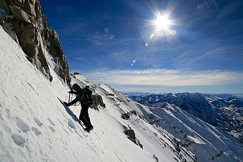
Photo by marauders.
From the saddle, the route follows Everest Ridge up to the summit ridge. Then follow the summit ridge north to the true summit. Everest ridge is not technically difficult, it is just flatout steep. The following are stats provided by PellucidWombat:
Everest Ridge
Distance: 1.38 mi
Elevation Changes +3,185' -70'
Everest Ridge - Summit
Distance: 0.37 mi
Elevation Changes +207' -144'
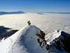
The last 600 feet to the summit ridge are called "The Step". This a rough, steep band of cliffs that can be fairly dangerous to navigate. This is definitely the crux of the route. We included some pictures as to how we got through this.
 Two options to ascend "The Step".
"The Step" Traverse (option 1)
Traverse to the right, under the base of the cliff bands. The traverse will take you around to an open face which will lead you directly to the summit ridge. Without snow, this traverse is steep, but the rock is stable. Once you gain the open face, the slopes are covered in loose talus. The scrambling is straight forward, but can be dangerous. Lining the bottom of this slope is band of 30-50 foot cliffs. Move up the talus as lightly as you can.This traverse is much easier with firm snow conditions covering the rock (winter/spring).
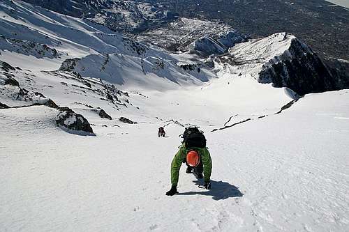
Photos by marauders.
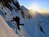
"The Step" Direct (option 2)
Climb directly up the cliff bands. The following info is provided by Joseph Bullough : "To avoid making the traverse around 'the step' we chose to climb directly up the cliff band. The climb is steep but relatively short (±60 ft.). The 4th class crux is a 6-foot vertical band near the top of the step, which requires a high-stepping mantel. There are several good holds but the consequences of a fall would be very ugly. Above the step a 50-foot rightward traverse across a steep slope regains the route followed by traversing around the step."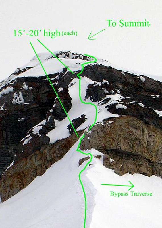
Photo by PellucidWombat. Check out this link, there are further comments about the height of these cliff bands.
In the winter/spring you must have axe/crampons. A rope is optional to navigate "the step."
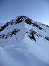
Summit Ridge
At the top of Everest Ridge, follow the summit ridge north to the summit of Mount Timpanogos. This ridge is tedious, but straight forward. The main danger is the large cornices, stay low on the ridgeline to avoid them. Delicate terrain on the summit ridge.
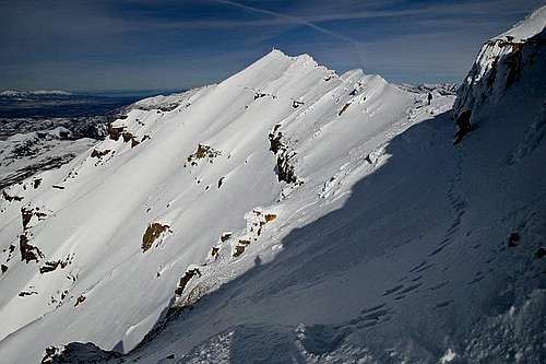 Summit ridge looking north.
 From the summit, looking south along the ridge toward Everest Ridge.
Trip Reports
For a thorough trip report, and many photos, from the fall season (no snow), visit my fall trip report.For a thorough trip report, and lots of photos, from the winter, see this my winter trip report.
For a thorough trip report, and lots of photos, from the winter, see this trip report from PellucidWombat.
Joseph Bullough - Feb 6, 2005 2:12 pm - Voted 10/10
Route CommentTo avoid making the traverse around 'the step' we chose to climb directly up the cliff band. The climb is steep but relatively short (±60 ft.). The 4th class crux is a 6-foot vertical band near the top of the step, which requires a high-stepping mantel. There are several good holds but the consequences of a fall would be very ugly. Above the step a 50-foot rightward traverse across a steep slope regains the route followed by traversing around the step.
PellucidWombat - Feb 7, 2005 10:58 am - Voted 10/10
Route CommentOh come on, the final rock pitch was quite a bit taller than me - it was more likely 10-13 ft.
PellucidWombat - Feb 8, 2005 4:15 pm - Voted 10/10
Route Comment8'-6"
PellucidWombat - Feb 8, 2005 1:15 pm - Voted 10/10
Route CommentDry Creek TH - Big Baldy Saddle
Distance: 2.84 mi
Elevation Changes +3,000'
Battle Creek TH - Big Baldy Saddle
Distance: 3.14 mi
Elevation Changes +3,200' -80'
Sagebrush Flat TH - Big Baldy Saddle
Distance: 1.92 mi
Elevation Changes +1,030' -260'
Everest Ridge
Distance: 1.38 mi
Elevation Changes +3,185' -70'
Everest Ridge - Summit
Distance: 0.37 mi
Elevation Changes +207' -144'
marauders - Feb 8, 2005 5:43 pm - Hasn't voted
Route CommentThanks for the addition. Great detail. If you don't mind, I'll put the figure on the main route page.
PellucidWombat - Feb 8, 2005 6:00 pm - Voted 10/10
Route CommentFeel free to - this is such a nice route I'd like to do as much as I can to contribute to the page.
If you'd like the the route overview pic that I submitted to show up as a large image on the route page, set is as (img src="http://www.summitpost.com/images/132825.JPG" HEIGHT=?). Just replace the ( with < and ) with > for the proper tags. To set the size, just try out some different numbers in place of the ? for height (e.g. 400)
Moogie737 - Jun 2, 2010 5:53 pm - Hasn't voted
How to get to the Dry Canyon THI-15, take the Lindon/1600 North-Orem exit, proceed east through town, climb and look for Skyline Drive to your left just prior to a sweeping right turn, proceed generally northward on Skyline Drive to Dry Canyon Drive, turn right and follow the pavement to the paved TH. Toilet and TH signs there. Don't be surprised by the ostentatious homes dotting the landscape - typical of public displays of debt. :)