
|
|
Route |
|---|---|
|
|
40.38460°N / 111.636°W |
|
|
Difficult and exposed scramble |
|
|
A long day |
|
|
Class 4 |
|
|
Class 4 |
|
|
Introduction and When to Climb
This is perhaps the most exciting, spectacular, and scenic route on Timpanogos. The route isn't too difficult, but it can be risky, especially along the Razorback Terrace. The route is almost never climbed and must be in prime condition to climb safely (see below). The Razorback Ridge section is class 3 and the Razorback Terrace section deserves its class 4 rating because of the extreme exposure. The route is also risky, especially when covered with snow. The remainder of the route is class 2+.This route was first mentioned in the book Climbing and Exploring Utah's Mount Timpanogos. The book is highly recommended and an excellent source for routes on Timpanogos, but on this route there is a slight problem. When the route was climbed and written about (1988), this was one of the warmest and driest years on record. In average, or heavy snow years, the traverse accross the terrace is much more risky (see below).
In a normal snowfall year, this route is in prime condition in late August to mid-September only. When the terrace is covered in snow (partially or completely), this can be a risky route because of the huge vertical drop below. The terrace often holds snow until mid-August or later, and is some years, doesn't melt out at all. Take an ice axe if there is snow on the terrace! Much of this route will be easier when covered with snow, but not the long traverse along the terrace. This route would be suicidal in Winter or Spring and avy danger is extreme during those seasons.
Note that this route reaches the Second Summit of Timp and not the Main Summit. The Second Summit is a peak in itself, and is only 27 feet lower (11,722') than the main summit.
 Route Diagram
Approach
From exit 275 on I-15 in Orem, drive east along Highway 152 and proceed to Highway 189 which runs through Provo Canyon. Drive up canyon to a place called Wildwood and turn north towards Sundance on the Alpine Loop Road/Highway 92. Drive north past Sundance and to Aspen Grove. Pack at the Aspen Grove Trailhead/Theater in the Pines Picnic Ground. The parking lot is packed on summer weekends! Route Map
Route Description- Part 1
 Hidden Lakes Cirque
The first part of the route follows the Aspen Grove Trail to Hidden Lakes. There isn't a need for a detailed description as this is amoung the most popular hikes in the state. Just follow the hordes up the trail! From the trailhead at 6850 feet, follow the paved trail west. The trail is even paved for the first mile or so to the first two waterfalls. Follow the trail up the spectacular Primrose Cirque while passing many beautiful waterfalls along the way. Follow the trail to the top of the Cirque. Immediately above the Primrose Cirque is another basin known as the Hidden Lakes Cirque. This is where you will leave the trail and crowds. There isn't a trail from here on.
Route Description- Part 2
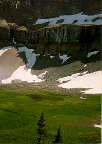
 Route to Col
Head SE along the lip of the beautiful flower-filled cirque past the tiny hidden lakes and towards the obvious col to the SE. Climb steeply up to the col. The route is class 2+ and very steep (more so than it appears in the photo). Make sure to zig zag up the slope (usually covered with snow until August) to avoid erosion. This col is between Elk Pont (point 10,791) on the north and Razorback Ridge to the south. Climb south up the Razorback Ridge. The route is class 3 and requires some use of hands. The ridge flattens out and has steep drops on either side. At the end of the level section of the ridge, the ridge becomes extremely steep and with many pinnacles and buttresses. Drop down to the north and onto the Razorback Terrace and follow the terrace west.
Route Description- Part 3
The Razorback Terrace traverse is very risky when snow covered. The terrace is a slope of about 45 degrees located above a huge cliff and below a huge cliff. If it is late summer, you will notice that mountain goats use this route and have left a faint trail. If the terrace has any snow at all on it (usually until at least mid or late August), an ice axe is an absolute must. Take extreme caution as this is a highly exposed route. Since there are often mountain goats above, take a helmut as well. This traverse is about half a mile long, but it seems much longer. When possible, climb to the north and to what is known as The Shoulder. It is the point directly to the SE of Emerald Lake. The most difficult section of the route is now behind you, so take a well deserved break at this incredible viewpoint. From the Shoulder, climb south up the north ridge of the Second Summit and scramble to the top at 11,722. The route is very steep, but only class 2+.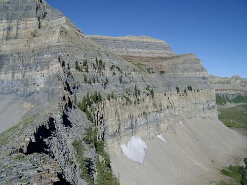 Side shot of the Razorback Terrace (middle of the photo)
Route Description- Part 3
From the summit, scramble down to the west along a faint trail to the Glacier Saddle. This saddle is also where the route joins with the Timp Glacier route up to the main summit. The Timp Glacier (which appears more like a snowfield most of the time), makes an excellent glissade down to Emerald Lake, when in prime condition (usually until early August, or only until much earlier in drought years). Unfortunately, the time when the Razorback Terrace is in prime condition is when the glacier is not! In drought years the glacier becomes a talus covered sheet of ice late in the summer (late August and September).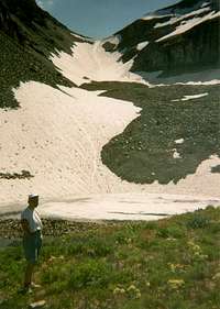 Timp Glacier
The glacier is somewhat of an unusual and interesting feature for Utah. A perhaps little known fact is that the glacier used to have some rather large (by Rockies standards) and visible crevasses before the Dust Bowl Route of the 1930's. Some of the old photos are available at BYU. After the 1930's drought, much of the glacier melted and has never recovered. After the Dust Bowl Drought the glacier was thought to be more of a perpetual snowfield over a rock glacier until the surface snow completely melted in the drought of 1994. During that year a large crevasse opened up in the talus, revealing glacial ice below. For now the glacier survives and is protected under the talus.
The route follows the glacier (an ice axe is helpful in all but late season in drought years) and down to Emerald Lake. From Emerald Lake, the main and crowded (but scenic) trail is followed back to Aspen Grove.
Time Needed
This route can be done in one long day. The route is shorter than, but takes longer than, the standard Aspen Grove Route to the main Timp summit. There are some nice campsites around Hidden Lakes for those who wish to camp and shorten the long day.Essential Gear
An ice axe and a helmet are recommended. In a dry year or very late in the season, an ice axe won't be needed, but if there is snow along the Razorback Terrace, an ice axe will always be needed. The exposed traverse of the Razorback Terrace is not hard, but rather exposed.
Wasatch Summits - Sep 14, 2012 10:53 pm - Voted 10/10
Video action.Here is an addition to this awesome route. This shows the route up over the ridge, across the terrace to the Shoulder, and the higher summits on the southern portion of Timp.