
-
 4020 Hits
-
 79.04% Score
-
 10 Votes
|
|
Mountain/Rock |
|---|---|
|
|
47.48336°N / 11.33659°E |
|
|
Hiking, Skiing |
|
|
Spring, Summer, Fall, Winter |
|
|
6795 ft / 2071 m |
|
|
Overview
 Feldernkopf (left) and Reissende Lahnspitze, Soiernspitze as seen from Mittenwalder Höhenweg
One of the many minor summits of the Soiern subgroup within Karwendel ranges is Feldernkopf. This grassy (south and west slopes) and rocky (north and east slopes) summit is located between Reißende Lahnspitze to the east and Schöttelkarspitze to the west.
Despite of its minor appearance and the rather low prominence in the ridge from Schöttelkarspitze to Soiernspitze, Feldernkopf is regularly visited by those doing the ridge traverse. To summit only Feldernkopf is – to my opinion – highly unusual in summer or autumn, nevertheless on a thunderstorm day I was happy to arrive at least at this minor peak before galloping down the south slopes to Ochsenalm where I found shelter from hail and lightnings.
In winter and spring, Feldernkopf is an interesting ski tour which is easier and more secure than the neighbouring ski routes to Reissende Lahnspitze or to Soiernspitze.
Getting There
 Feldernkopf summit with Schöttelkarspitze
Main trailheads for Feldernkopf are
You reach Krün and Mittenwald by car
If you go by train, the best trailhead is Mittenwald / Kasernen, about 0,5 hours away from Mittenwald railway station.
Main Routes Overview
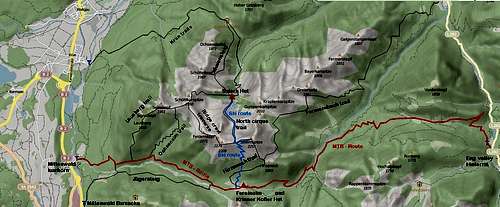 Routes of Soiern subgroup
from Mittenwald / Isarhorn or Mittenwald / Kasernen trailhead
- Route 1: trailheads – forest road – turn left on Lausberg trail – Lausberg – Signalkopf – Seinskopf – Feldernkopf
- Route 2: trailheads – forest road – Ochsenalm trail to Feldernkopf; this is a ski route, too;
- continue on the ridge trail to Reißende Lahnspitze – Soiernspitze and descend via Hirzeneck – Fereinalm – forest road or Jägersteig back to Mittenwald; great and classic traverse of Soiern group (=Ridge Crest Route);
- a ski traverse can be done from Feldernkopf to Reißende Lahnspitze and to Soiernspitze via the Ridge Crest Route.
 Feldernkopf (right) and Reissende Lahnspitze Feldernkopf (right) and Reissende Lahnspitze |  Feldernkopf with Ridge Crest Trail Feldernkopf with Ridge Crest Trail |
from Krün
- Trailhead – forest road to Fischbachalm – forest road or trail (Lakaiensteig) to Soiernhaus – Soiernsee – Schöttelkarspitze – Feldernkopf; continue on the Ridge Crest Trail to Reißende Lahnspitze and Soiernsattel, decend the trail to Soiernsee – Soiernshaus and back to Krün; the summit of Soiernspitze can be reached from Soiernsattel within 20 minutes;
- The ski route from Krün follows the summer route up to Soiernsee. The route navigates round the west shore of Soiernsee and ascends the north cirque below Feldernkopf tot he summit. This route needs much snow to covert he rocks oft he north slopes of Feldernkopf.
 Summit view to Soiernspitze and Reißende Lahnspitze with Ridge Crest Trail Summit view to Soiernspitze and Reißende Lahnspitze with Ridge Crest Trail |  Summit view to Schöttelkarspitze Summit view to Schöttelkarspitze |
Signposts:
The whole region has yellow signposts at trail junctions and trailheads to indicate directions. These signs show hiking hours and minutes to destinations, too, which sadly are often wrong (ways too long or too short). My advice: don´t take them into account!
Red Tape & Accommodation
The whole Soiern subgroup belongs to the nature protection area „Karwendel und Karwendelvorgebirge”, which covers nearly the whole German Karwendel area and is thus part of the huge Alpenpark Karwendel.The entrance is free.
Please respect the following rules in the Nature Protection Area:

You find all kind of accommodation at
Mittenwald
Krün
Wallgau
Mountain huts
Soiernhaus
Ferein Alm; also called Fereinsalm, Vereinalm or Vereinsalm; no overnight stay
Krinner-Kofler-Hütte, located near Fereinalm
When to Climb
 Feldernkopf (left) with Soiern subgroup as seen from Wörnersattel
Feldernkopf is a year round summit.
All summer and autumn routes are hiking routes which are marked and signposted. The full ridge traverse to Soiernspitze is a long and strenuous undertaking. In winter with little snow, Feldernkopf south route 2 may be open for a winter hike.
Full hiking gear is needed for Feldernkopf.
Feldernkopf is an interesting ski tour and is more secure and easier than the ski routes to Reißende Lahnspitze and Soiernspitze.
The south route uses the south slopes above Ochsenalm and is the easiest route to Feldernkopf. A dream with powder snow! The north route needs much snow to cover the rocks of the Feldernkopf north slopes; avalanche danger is one of the crucial points on that route. The denomination of the neighbour summit, Reißende Lahnspitze, which means “Torrential Avalanche Peak”, points out that there can be nasty avalanche incidents.
No ski tour for beginners. The same goes for the ridge crest traverse on skies.
Check the Bavarian avalanche bulletin here.
Current Weather for Mittenwald:
Maps & Guide Book
MapsTopographische Karte, scale 1 : 50.000, Karwendelgebirge, Werdenfelser Land; Landesamt für Vermessung und Geoinformation Bayern
Alpenvereinskarte Bayerische Alpen, scale 1 : 25.000, map number BY 12, Karwendelgebirge Nord, Schafreiter; Deutscher Alpenverein, Landesamt für Vermessung und Geoinformation Bayern, 2010 (covers the easternmost parts of Soiersnspitze with Fermersbach trail and MTB route from Hinterriß)
Alpenvereinskarte Bayerische Alpen, scale 1 : 25.000, map number BY 10, Karwendelgebirge Nordwest; Deutscher Alpenverein, Landesamt für Vermessung und Geoinformation Bayern, 2010
Guide Book
Heinrich Klier, Fritz März, und Walter Klier: Alpenvereinsführer Karwendelgebirge alpin, Bergverlag Rother, 2005